From Eve
Know before you go
Hi, I'm Eve. Here are a few practical things to know before exploring Mize Mill Falls.
Local know-how to help you travel smarter and make the most of every moment.

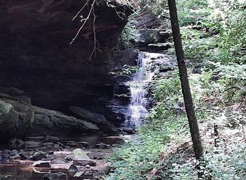
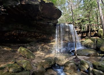
Discover the serene beauty of Mize Mill Falls in Bankhead National Forest, a hidden oasis with cascading waters and lush natural surroundings.
Mize Mill Falls is a picturesque waterfall nestled in Bankhead National Forest near Double Springs, Alabama. This hidden gem offers a short, rewarding hike to a beautiful, secluded cascade, perfect for nature lovers and photographers alike [5, 6, 7].
Opening times, essentials, and a few local tips gathered into one calmer, easier-to-scan planning section.
Hi, I'm Eve. Here are a few practical things to know before exploring Mize Mill Falls.
Local know-how to help you travel smarter and make the most of every moment.
Driving
From Double Springs, take Highway 33/CR41 north for approximately 12.5 miles [5, 6, 8]. Turn left onto Cranal Road (County Road 60) and continue for about 3.5 to 4 miles [5, 6]. The trailhead is on the left side of Cranal Road, marked by a small, unsigned pull-off area just past the Sipsey River bridge [6]. Parking is limited to a few vehicles [1, 6, 7]. Be cautious of traffic when crossing the road to access the trail [6].
Walking
If starting from the Sipsey River Picnic Area, cross Cranal Road and walk east for approximately half a mile [1, 6]. Look for a small dirt road on the opposite side of Cranal Road [1, 6]. The trail starts across from this dirt road [2, 6]. Be extremely careful of fast-moving vehicles on Cranal Road as you walk along the shoulder [1, 6]. There are no sidewalks [6]. Note that there is a $3 use fee for the Sipsey River Picnic Area [3, 8].
Use Tower Bridge as your starting point for nearby food, family ideas, nightlife, and more local discoveries.

Explore expert travel guides, compare and book tours, experiences, hotels, and more—all from the palm of your hand. Download now for seamless trip planning wherever your wanderlust takes you.

Discover Central Alabama: A blend of rich history, natural beauty, and Southern hospitality awaits in this charming region.
Tell me more about Central Alabama