Ringborgen Rispebjerg
Bornholm’s largest Iron Age ring fort layered over a Neolithic sun temple, where soft ramparts, woodhenge traces and wide valley views bring 5,000 years of ritual and refuge to life.
Where a sun temple meets an Iron Age stronghold
Perched on a defensible headland near Aakirkeby, Ringborgen Rispebjerg is one of Bornholm’s most evocative archaeological landscapes. Long, grassed-over ramparts trace the outline of a sizeable Iron Age fort, once encircling a four-hectare enclosure that sheltered people and livestock in times of danger. From the top of the earthworks you look straight down into the green ribbon of the Øleådalen valley, a natural moat that made this promontory such a strategic refuge. Today the fort’s banks rise only a few metres, softened by turf and wildflowers, but it takes little imagination to picture timber palisades crowning the ramparts and lookouts watching the approaches. Recent excavations have revealed concentric lines of ditches and banks, emphasizing how seriously the community took defense around the time of the birth of the Common Era. Walking the circuit, you move through the footprint of Bornholm’s largest known Iron Age fortification.Traces of a Neolithic ‘woodhenge’
Beneath the younger fortification lies an even older story. Around 2800 BC, Neolithic farmers built a complex of wooden circles here – so‑called woodhenges – using massive posts set in carefully cut pits. Archaeologists have uncovered several rings, each seven to ten metres across, and their locations are now marked by low stumps so you can read the pattern on the ground. From fragments of fired clay, scorched flint and burned animal bone, researchers suggest that at least one of these circles carried a clay‑covered platform reached by steps, where fires may have blazed during ceremonies. The alignment of entrances with the sun’s course and the discovery of engraved “sun stones” elsewhere on Bornholm have led to the idea of Rispebjerg as part of a wider sun‑focused ritual landscape. Standing within a recreated circle, it is easy to imagine gatherings timed to dawn, dusk or the turning of the seasons.Archaeological finds in a sacred landscape
The modern story of Rispebjerg began in 1897 when workers near a nearby spring uncovered a cache of finely made flint axes and chisels, soon followed by more. Their concentration beside flowing water suggested offerings rather than lost tools, highlighting the spiritual significance of the area for mid‑Neolithic communities. The finds helped place Bornholm firmly on the archaeological map. Ongoing investigations have since documented houses, workshop areas and traces of palisades belonging to the Funnel Beaker culture, indicating that this was not just a ceremonial site but also a lived‑in landscape. The mix of imported and local flint shows far‑reaching contacts across the Baltic. Yet many questions remain: how exactly rituals unfolded on the platform, what myths were attached to the sun symbols, and how the meaning of the hilltop shifted as the Iron Age fort rose above older sanctuaries.Walking the earthworks and reading the ground
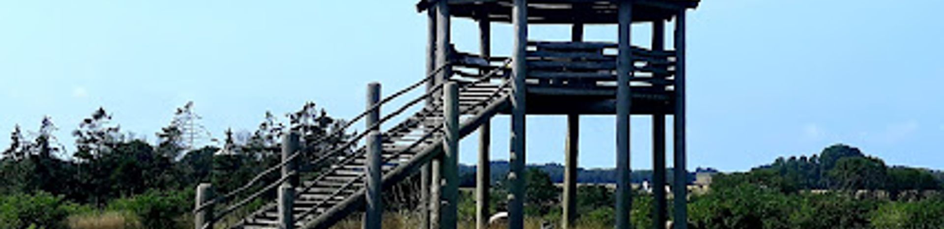
For visitors today, Rispebjerg is an open, grassy site threaded with informal paths rather than a fenced museum. A small observation tower offers a clear overview of the semicircular ramparts, the valley and the patchwork of fields beyond, helping you orient the different time layers. Simple information boards explain key features and point out where the woodhenges and fortifications lie relative to what you see. The terrain is gently undulating, with a few steeper slopes where the land drops towards the valley. Most of the walking is on dirt tracks and meadow paths, so sturdy shoes are sensible, especially after rain. There is little shade, which makes the site particularly striking in clear weather when the Baltic light sharpens the profile of the banks and distant farmsteads. Many visitors combine a slow circuit of the ramparts with quiet time sitting on the grass, letting the subtle contours of the landscape come into focus.Atmosphere across the seasons
Rispebjerg changes character with the time of year. In spring the ramparts are dotted with fresh greens and early flowers, the views bright and the air cool enough for longer explorations. Summer brings taller grasses, buzzing insects and a more golden palette across the valley; on warm days the open setting can feel almost Mediterranean. Autumn mists sometimes collect in the low ground, enhancing the sense of age and mystery that suits a former sun temple and refuge. Whatever the season, the absence of intrusive structures keeps attention on the land itself: the curve of the banks, the line of the valley and the quiet patterns picked out with wooden markers. It is a place for unhurried wandering, contemplation and an imaginative leap back to communities who watched the same horizons thousands of years ago, measuring time by the sun and seeking safety behind the same slopes that still cradle the site.Local tips
- Wear sturdy shoes: trails follow grass and dirt over low ramparts and can be slippery after rain or in early spring.
- Bring water and sun or wind protection; the hilltop is exposed with little natural shade or shelter.
- Allow time to climb the observation tower first to understand the layout of the fort and Neolithic circles before exploring on foot.
- Combine a visit with nearby sites on southern Bornholm to appreciate the wider ritual landscape and Iron Age defenses.
A brief summary to Ringborgen Rispebjerg
- Margrethe II's Vej, Aakirkeby, 3720, DK
- Visit website
Getting There
-
Car from Aakirkeby
From central Aakirkeby, driving to Rispebjerg typically takes 10–15 minutes along local country roads. Surfaces are paved almost all the way, with a short stretch on a narrower access road near the site. There is usually free parking by the entrance, but spaces are limited in peak summer and the ground can be uneven. Fuel stations are only in town, so plan ahead.
-
Bicycle from Aakirkeby
Cycling from Aakirkeby to Rispebjerg generally takes 25–40 minutes each way, depending on fitness and wind. The route follows quiet rural roads with gentle hills, but there are no dedicated cycle paths for most of the distance. Surfaces are asphalt with some gravel near the site, and lighting is minimal, so this option is best in daylight and fair weather.
-
Bus plus walk from larger Bornholm towns
From towns such as Rønne or Nexø, regional buses run to Aakirkeby in about 25–40 minutes, with standard local fares typically around 25–40 DKK one way. Services are less frequent on weekends and outside summer. From Aakirkeby, you continue on foot through countryside paths and minor roads; expect 45–60 minutes of walking each way on mixed gravel and grass, which may be muddy after rain and is not ideal for those with limited mobility.


