Trehøje Mols
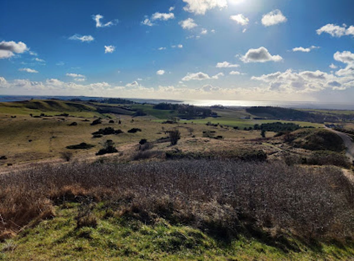
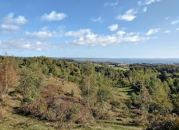
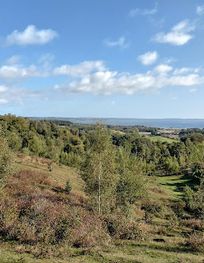
Three Bronze Age mounds offering panoramic views across Denmark's largest grassland and surrounding coastline.
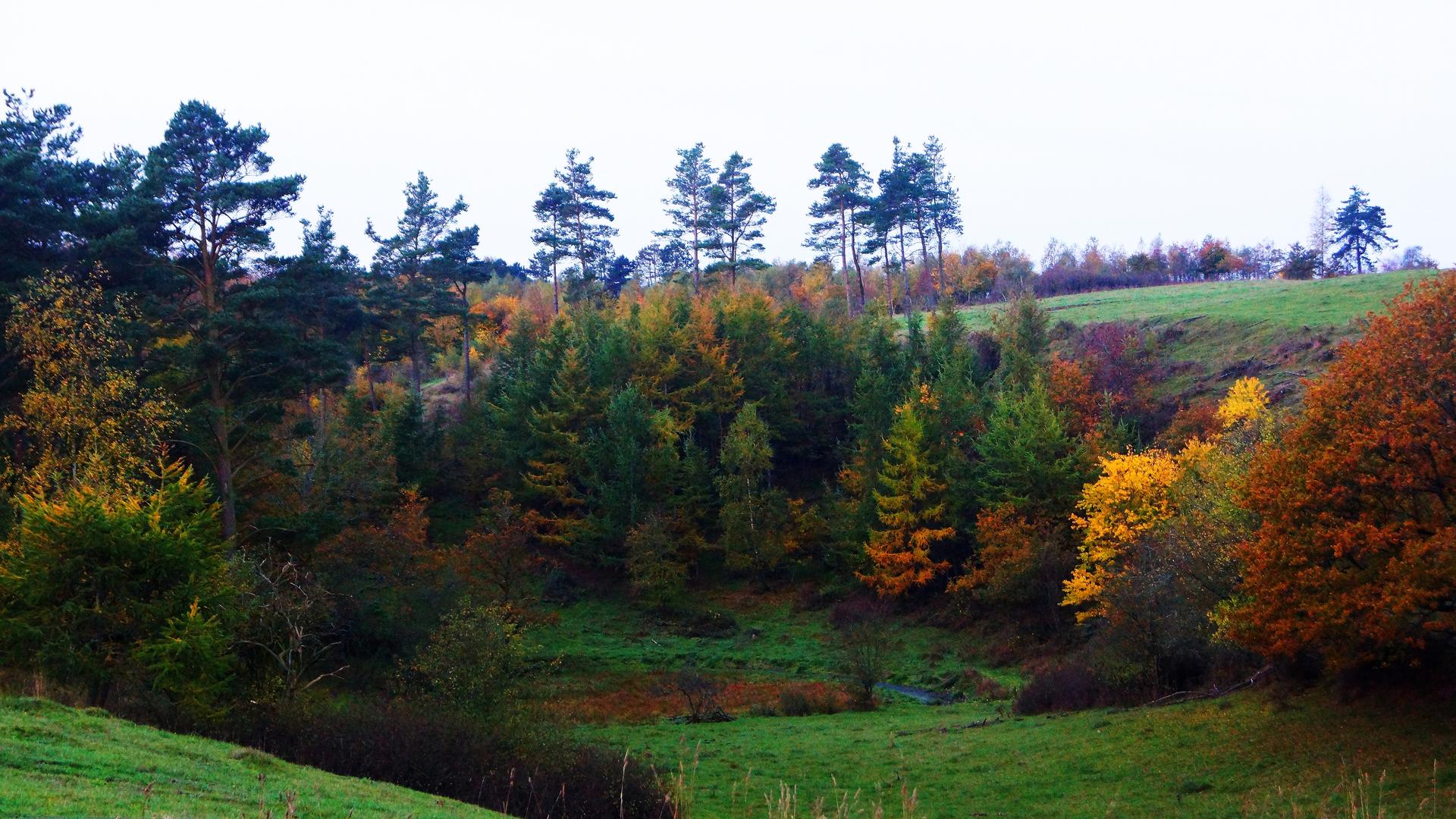
Three iconic Bronze Age mounds rising 127 metres above sea level in Mols Bjerge National Park, offering panoramic views across Djursland's undulating landscape and the surrounding coastline. These distinctive hilltops are surrounded by Denmark's largest grassland area, featuring open expanses of wildflowers, juniper bushes, and wavy hair grass that turns brown-purple in midsummer. Well-maintained trails connect the three summits, making this a scenic destination for hiking, cycling, and nature exploration year-round.
A brief summary to Trehøje Mols
- Knebel, 8420, DK
- Duration: 1.5 to 4 hours
- Free
-
Outdoor
- Mobile reception: 4 out of 5
Local tips
- Visit early morning for the best light, clearest views, and fewest crowds. The parking area is small and can fill during peak summer hours.
- Choose clear weather days for optimal panoramic views. Overcast or misty conditions significantly reduce visibility across the inlets and distant landscapes.
- Plan a midsummer visit (June–July) to witness the distinctive brown-purple flowering of wavy hair grass that transforms the grassland landscape.
- Combine your visit with nearby attractions: Agri Bavnehøj (137 metres, the highest point), Tinghulen kettle hole, and the medieval church in Knebel town.
- Bring binoculars for bird watching and to spot distant landmarks. The open grassland supports diverse bird populations, especially during migration seasons.
For the on-the-go comforts that matter to you
- Parking Areas
- Information Boards
- Picnic Areas
- Trash Bins
Getting There
-
Car with Parking
Drive directly to the designated parking area at the foot of Trehøje. The lot is small and can reach capacity during summer peak hours (10:00–16:00). Travel time from Aarhus city centre is approximately 40–50 minutes (40 kilometres). From Ebeltoft town, allow 20–25 minutes (18 kilometres). Parking is free. In summer months, shuttle bus services may operate from visitor centres to manage parking pressure.
-
Regional Bus Service
Public buses serve Mols Bjerge National Park with stops within the park area. Journey time from Aarhus central station is approximately 60–75 minutes depending on route and connections. Bus services operate year-round with reduced frequency in winter months. From Knebel town centre, local buses reach the park in 15–20 minutes. Check regional transport schedules (Midttrafik) for current routes and timetables, as services vary seasonally.
-
Bicycle from Knebel
Cycle from Knebel town (approximately 5 kilometres away, 20–30 minutes ride). The route follows regional cycling paths through the Djursland landscape. This option is suitable for visitors with moderate fitness levels. Bike rental is available in Knebel. The approach is scenic and allows exploration of the surrounding area at a leisurely pace.
-
Walking from Parking Area
From the parking area at the foot of the hills, well-maintained trails lead to all three summits. The walk to the highest point takes approximately 30–45 minutes depending on fitness level and route chosen. Trails are clearly marked and suitable for most visitors. The terrain is hilly but not technically demanding.
Trehøje Mols location weather suitability
-
Clear Skies
-
Mild Temperatures
-
Any Weather
Discover more about Trehøje Mols
Ancient Mounds and Panoramic Horizons
Trehøje consists of three majestic hilltops that rise 127 metres above sea level, making them prominent landmarks within Mols Bjerge National Park on the Djursland peninsula. These hills are far more than simple geographical features—they are Bronze Age burial mounds with archaeological significance dating back thousands of years. The landscape rises steeply from the coast, creating an optical illusion that makes the hills appear taller than their modest elevation. From the summits, visitors experience one of Denmark's most expansive panoramic views, stretching from Aarhus to Ebeltoft and encompassing four major inlets: Kalø, Begtrup, Knebel, and Ebeltoft Vig. On exceptionally clear days, the view extends all the way to Sjællands Odde on the island of Zealand.A Living Landscape of Grassland and Seasonal Colour
The hills are surrounded by East Jutland's largest continuous grassland area, a landscape shaped by ice age geology and preserved through careful management. The open expanses feature wildflowers, scattered juniper bushes, and deciduous undergrowth that create a dynamic natural environment. During midsummer, the distinctive wavy hair grass blooms, transforming the entire landscape into shades of brown and purple—a phenomenon that makes this season particularly striking for visitors. The nutrient-poor sandy soils left by retreating glaciers support this unique ecosystem, contrasting sharply with the intensely farmed fertile clay lands visible to the southwest. This ecological diversity makes Trehøje an exceptional destination for nature observation, berry and mushroom gathering, and understanding Denmark's post-glacial landscape evolution.Geological Legacy of the Ice Age
The three hills themselves are products of the last ice age, when massive glacial masses pushed up the landscape, creating the undulating topography that defines Mols Bjerge. The surrounding terrain reveals additional ice age features, including kettle holes and outwash plains where meltwater once deposited vast quantities of sand and gravel. The landscape also preserves evidence of medieval agricultural practices—the so-called high-ridged fields visible between Trehøje and nearby Toggerbo are ancient plough furrows created when heavy wheeled ploughs were introduced in the early Middle Ages. These ridge patterns, resembling waves frozen in the earth, tell the story of how farmers adapted their techniques to the challenging terrain.Trails and Visitor Experience
Well-maintained trails radiate from the parking area at the foot of the hills, connecting the three summits and extending throughout the surrounding national park. The walks are manageable for most visitors, with the summit trails offering increasingly expansive views as elevation increases. Visitors can explore the area on foot, by bicycle, or on horseback, with multiple parking areas available throughout Mols Bjerge. The trails pass through the open grassland landscape, allowing intimate contact with the unique flora and seasonal transformations. Early morning visits offer the best light for photography and the quietest experience, as crowds tend to build during midday hours.Protected Status and Conservation
Mols Bjerge National Park received protected status in 1994, ensuring the preservation of this distinctive landscape for future generations. The park's management focuses on maintaining the open grassland character and removing invasive conifer plantations that were introduced over the past 200 years. This active restoration work aims to recreate a more varied and historically authentic natural environment. The Bronze Age mounds themselves represent irreplaceable archaeological heritage, connecting modern visitors to prehistoric settlement patterns and burial practices. The entire area functions as both a nature reserve and an open-air museum of landscape history.Seasonal Transformations and Best Times to Visit
Each season brings distinct character to Trehøje. Spring brings wildflower blooms and returning bird populations. Summer transforms the grasslands with the distinctive purple-brown flowering of wavy hair grass, creating the landscape's most visually striking period. Autumn offers clear air, reduced crowds, and excellent conditions for long-distance views. Winter provides stark beauty and the clearest visibility across the landscape, though weather conditions can be challenging. Clear weather is essential for experiencing the full panoramic views; overcast or misty conditions significantly reduce visibility across the inlets and distant coastlines.For the vibe & atmosphere seeker
- Scenic
- Adventurous
- Tranquil
- Unique
For the design and aesthetic lover
- Rustic Designs
- Minimalist Designs
For the architecture buff
- Historic
- Landmarks
- Parks & Gardens
- Sacred Sites
For the view chaser and sunset hunter
- Panoramas
- Iconic Views
- Sunrise Spots
- Sunset Spots
For the social media creator & influencer
- Instagrammable
- Photo Spots
- Architectural Shots
- Panoramas
For the eco-conscious traveler
- Protected Area
- Nature Reserve
- Locally Managed
- Wildlife Habitat
- Low Impact
For the kind of experience you’re after
- Cultural Heritage
- Myth & Legends
- Nature Escape
- Photowalk
- Day Trip
For how adventurous you want the journey to be
- Easy Access
- Requires Hike
Location Audience
- Family Friendly
- Senior Friendly
- Solo Friendly
- Couple Friendly
- Pet Friendly