Background

Stormflodssøjlen på Mandø

Stone sentinel marking centuries of catastrophic storm surges that reshaped the Wadden Sea coast.

4.5

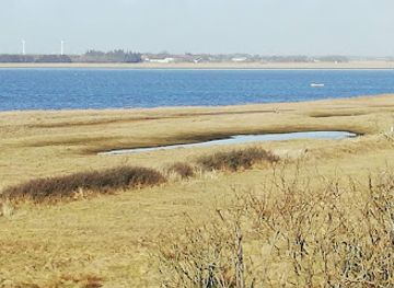
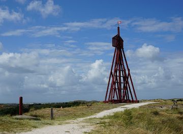
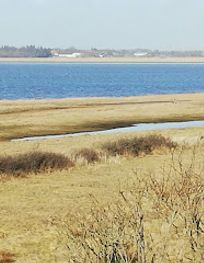
A stark stone column marking the water levels of catastrophic storm surges that have battered Denmark's west coast for centuries. Standing on the tidal flats near Mandø Island, this weathered monument records the devastating 1634 flood that killed thousands, with its highest mark showing water that rose 6 meters above normal sea level. A haunting reminder of nature's power and human resilience.

A brief summary to stormflodssøjlen mandø

  • Strandvej 2, Ribe, 6760, DK
  • Duration: 0.5 to 2 hours
  • Free
  • Environment icon Outdoor
  • Mobile reception: 3 out of 5

Local tips

  • Visit during low tide to safely access the column on the tidal flats. Check tide tables in advance—timing is essential for both safety and the full experience of walking across the exposed seabed.
  • Bring binoculars and a camera. The column's carved marks are small and require close inspection, and the surrounding Wadden Sea landscape offers exceptional photography opportunities, especially during golden hour.
  • Combine your visit with Mandø Island exploration. The island is accessible by car during low tide via the tidal road from Vester Vedsted, offering a unique driving experience across the seabed.
  • Visit the Vadehavscentret (Wadden Sea Centre) nearby for context about the region's geology, ecology, and storm surge history before or after viewing the column.
  • Wear waterproof footwear and check weather forecasts. Even during low tide, the ground can be muddy and slippery, and weather conditions can change rapidly on the exposed flats.
widget icon

Getting There

  • Car via Tidal Road from Vester Vedsted

    Drive from Vester Vedsted to Mandø Island via the tidal road (Mandøvej), which crosses the exposed seabed. The journey takes approximately 10–15 minutes depending on tide level. This route is only passable during low tide; consult tide tables before departing. The column is located near the base of the dunes on Strandvej on Mandø. Note: Salt water exposure can corrode vehicle undercarriages; rinse thoroughly afterward. No toll required.

  • Walking from Vester Vedsted

    From Vester Vedsted, walk across the tidal flats toward Mandø Island during low tide. The distance is approximately 3–4 kilometers and takes 45 minutes to 1 hour depending on terrain and tide conditions. The ground is muddy and uneven; wear waterproof boots. The column is located on the western side of Mandø near the dunes. This route offers immersive views of the Wadden Sea landscape but requires careful attention to tide times to avoid being cut off.

  • Guided Tour from Ribe

    Join a guided tour operator based in Ribe (approximately 8 kilometers away, 15–20 minutes by car) that specializes in Wadden Sea and Mandø Island excursions. Tours typically include transportation, tide-time coordination, and historical interpretation. Prices generally range from 400–700 Danish kroner per person. Tours operate year-round but are most frequent during spring and autumn.

  • Bicycle via Tidal Road

    Cycle from Vester Vedsted to Mandø Island during low tide using the same tidal road as vehicles. The journey takes approximately 20–30 minutes. Terrain is flat but muddy and slippery; a mountain or hybrid bike is recommended. The column is accessible by bicycle once on Mandø. This option offers flexibility and a closer connection to the landscape than driving.

stormflodssøjlen mandø location weather suitability

  • Weather icon Clear Skies
  • Weather icon Mild Temperatures
  • Weather icon Cold Weather

Unlock the Best of stormflodssøjlen mandø

Buy tickets

    No tickets available

Book tours with entry

    No tours available

Book tours without entry

    No tours available

Discover more about stormflodssøjlen mandø

A Monument to Centuries of Coastal Fury

The Stormflodssøjlen (Storm Surge Column) on Mandø stands as a silent witness to the relentless power of the North Sea. Located on the tidal flats near Mandø Island in the Wadden Sea, this weathered stone column bears carved rings and marks that chronicle the water levels of the most devastating storm surges to strike Denmark's western coast. Each mark represents a catastrophe—a night when the sea overwhelmed defenses and claimed thousands of lives. The column's highest marking, dating to 1634, shows water that rose 6.3 meters above normal sea level, a height that seems almost incomprehensible when standing before the monument.

The Catastrophe of 1634: The Second Great Drowning

On the night of October 11, 1634, a storm surge of unprecedented fury swept across the entire west coast of Jutland. Known as "Den Anden Store Menneskedrukning" (The Second Great Drowning), this disaster claimed between 8,000 and 15,000 lives across the region. The water rose so high that it penetrated far inland, flooding entire communities and inundating churches. In Ribe's cathedral, the water level was marked 1.7 meters above the floor on a pillar behind the pulpit—a mark that remains visible today. The worst devastation occurred on the island of Nordstrand, where the sea breached 44 dikes, drowning 6,000 of the island's 9,000 inhabitants. Approximately 50,000 cattle and horses perished in the floodwaters, and 19 of the island's 22 churches were destroyed. The 1634 storm remains the most catastrophic storm surge in recorded Danish history.

Mandø's Struggle with the Sea

Mandø Island itself has endured repeated inundations throughout its history. The earliest recorded catastrophe occurred on November 1, 1532, when a massive storm surge swept across the Wadden Sea coast on All Saints' Day. The water rose so high that it reached 1.8 meters inside the Church of Saint Lawrence in nearby Tønder, indicating a water level of approximately 5.3 meters above normal sea level. On Mandø, the surge was so violent that it completely destroyed the original settlement and the medieval church on Gammel Mandø (Old Mandø), leaving not even the foundation standing. According to legend, all inhabitants except eight men—who happened to be on the mainland—perished. These eight men later traveled to Fanø, found wives, and returned to rebuild their island community. The survivors established a new settlement on the southern part of Mandø, constructing a new church in 1570. The 1532 flood literally split Mandø into two islands, a division that shaped the island's geography for centuries.

Reading the Record in Stone

The column itself functions as a historical archive, with each marked ring representing a significant storm surge. The marks tell a story of recurring danger: the 1634 surge at 6.01 meters, the December 1999 storm at 5.50 meters, the November 1825 event at 5.33 meters, the November 1981 storm at 5.01 meters, and the January 1976 surge at 4.70 meters. A storm surge is officially recorded when wind-driven water reaches 2.40 meters above the Danish Vertical Reference (DVR 90). When water levels exceed 4.00 meters, the lowest dikes—particularly those near Ballum—are threatened, putting settlements and lives at risk. The column's markings serve as a tangible record of the sea's power and a sobering reminder that such events are not historical anomalies but recurring threats.

Modern Defenses and Ongoing Vigilance

Following the catastrophic 1923 storm surge—which killed an engineer and 18 dike workers during construction of the Rejsbydiget—the entire coast from Ballum in the south to Tjæreborg in the north was secured with modern dikes. Today, these dikes stand 7 meters high, designed to withstand storm surge combined with wave runup of 1 to 1.5 meters. Yet the column remains, not as a relic of a solved problem, but as a warning. The Wadden Sea region continues to be monitored closely, and storm surge predictions are issued regularly during autumn and winter months when the greatest risks occur. The column's presence on the tidal flats—accessible only during low tide—makes it a pilgrimage site for those seeking to understand the region's relationship with the sea.

Busiest months of the year

Busiest hours of the day

Popular Experiences near stormflodssøjlen mandø

Popular Hotels near stormflodssøjlen mandø

Select Currency