Christianshavns Kanal
Historic waterway where maritime heritage meets contemporary urban culture in Copenhagen's most distinctive neighbourhood.
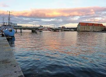
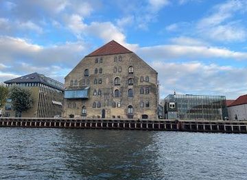
A Waterway Born from Royal Ambition
Christianshavns Kanal flows through one of Copenhagen's most distinctive neighbourhoods, a place shaped by the vision of King Christian IV in the early 17th century. In 1612, the Danish monarch initiated an ambitious programme to fortify Copenhagen, and between 1618 and 1623, he constructed earthen embankments with five bastions in the marshy area between Copenhagen and the island of Amager. The canal itself became the defining feature of the new merchant town of Christianshavn, established in 1639. Running northeast to southwest, the waterway bisects the neighbourhood along its entire length, connecting to Trangraven in the north and emptying into the main harbour near Langebro bridge in the south. The canal's creation was inspired by Dutch urban planning, reflecting Christian IV's admiration for Amsterdam's waterfront design. This Dutch influence shaped not only the physical layout but also the character of Christianshavn, which developed as a privileged merchant's town with its own distinct identity. Though the town was incorporated into Copenhagen by 1674, the canal remained the neighbourhood's most defining feature, preserving the maritime atmosphere that characterised the area for centuries.The Living Waterfront: Boats, Bridges, and Community
Today, Christianshavns Kanal is renowned for its bustling sailing community, particularly in the northern half where numerous houseboats and sailboats create a dynamic waterfront scene. The canal is crossed by two bridges: Børnehusbroen, which carries Torvegade (the main thoroughfare of Christianshavn) at the canal's midpoint, and Snorrebroen further north. The two streets running along each side of the canal—Overgaden oven Vandet and Overgaden neden Vandet—date back to the original foundation of Christianshavn and frame the waterway with historic buildings, restaurants, and galleries. The canal's banks have become gathering places for locals and visitors alike. Joggers, cyclists, and pedestrians frequent the waterside paths, while the numerous cafés and bars along the canal create informal meeting spaces. The water itself remains active with boat traffic, maintaining the maritime character that has defined the neighbourhood since its inception. The contrast between the historic architecture and contemporary urban life creates an atmosphere of authenticity and vitality.Cirkelbroen: Art, Design, and Urban Renewal
In 2015, artist Olafur Eliasson completed Cirkelbroen, a revolutionary pedestrian bridge that has become an iconic symbol of contemporary Copenhagen. The bridge consists of five staggered circular platforms of varying diameters (ranging from ten to fourteen metres), each topped with a steel mast rising up to twenty-five metres high. Thin steel cables extend from these masts to the platforms' circular railings, creating a distinctive visual signature inspired by the ship masts that once dominated Copenhagen's harbour. Eliasson drew direct inspiration from Christianshavn's maritime heritage and his own childhood memories of fishing boats in Iceland. The bridge's zigzag design deliberately encourages pedestrians and cyclists to slow their pace, pause, and engage with their surroundings rather than rushing across. One section functions as a swing bridge, rotating to allow larger vessels to pass through the canal. Lit at night, Cirkelbroen connects Christiansbro with Applebys Plads and serves as part of a larger pedestrian circle around Copenhagen Harbour, offering visitors a completely different perspective of the city. The bridge attracts approximately 5,000 crossings daily and has become a beloved meeting place and photography destination.Historic Landmarks and Cultural Significance
The streets flanking Christianshavns Kanal contain several notable historic buildings that tell the story of the neighbourhood's development. Brøstes Samling, located at Overgaden oven Vandet No. 10, occupies a building from 1785 known as Potters Gård (Potter's House). This local history collection is housed in a structure named after Thomas Potter, a Scottish-born entrepreneur who arrived in Copenhagen as a young man and became a pioneer in iron production, manufacturing pots, nails, anchors, and bullets for export to the East and West Indies. Søkvæsthuset, at Overgaden oven Vandet No. 38, was constructed in 1754 as an orphanage for boys and later converted into a naval hospital in 1776. Since 1989, its side wing has housed the Royal Danish Naval Museum, preserving the area's deep connection to maritime history and naval tradition. These buildings serve as physical reminders of Christianshavn's evolution from a fortified merchant town to a vibrant urban neighbourhood.Contemporary Life Along the Water
Christianshavns Kanal today embodies the neighbourhood's transformation from a 20th-century working-class district to a fashionable, diverse, and lively part of Copenhagen. The waterfront attracts a mix of businessmen, students, artists, and families who live and work in the surrounding buildings. The canal's atmosphere shifts throughout the day and seasons: mornings bring joggers and cyclists, afternoons see students and professionals gathering at waterside cafés, and evenings transform the space into a social hub with restaurants and bars drawing crowds. The neighbourhood's bohemian reputation, developed in the 1970s, continues to influence the cultural character of the area. Street art decorates the walls, independent bookshops and record stores line the streets, and the waterfront remains a place where spontaneous encounters and cultural exchange occur naturally. The canal serves not merely as a geographic feature but as the social and cultural heart of Christianshavn, connecting its historic past with its vibrant present.Local tips
- Visit during golden hour (late afternoon) to photograph Cirkelbroen and the canal's reflections in the water, when the bridge's steel cables and masts create dramatic silhouettes against the sky.
- Walk along both Overgaden oven Vandet and Overgaden neden Vandet to experience the full character of the canal; each side offers different perspectives, historic buildings, and local establishments.
- Pause on Cirkelbroen's circular platforms rather than rushing across; the bridge's design intentionally encourages reflection and provides excellent vantage points for observing boat traffic and neighbourhood life.
- Explore the nearby Royal Danish Naval Museum in Søkvæsthuset to understand Christianshavn's maritime significance and the role of the canal in Copenhagen's naval history.
- Visit during spring and summer when the sailing community is most active; the northern section of the canal becomes particularly lively with houseboats and waterfront social activity.
A brief summary to Christianshavns Kanal
- Copenhagen Municipality, Indre By, DK
Getting There
-
Metro / S-train
Take the Copenhagen Metro Line M1 or M2 to Christianshavn Station (approximately 8–12 minutes from central Copenhagen depending on starting point). Exit and walk 3–5 minutes to reach the canal. The station is directly adjacent to the neighbourhood. Cost: approximately 24 DKK for a single journey within Copenhagen zones.
-
Bus
Multiple bus routes serve Christianshavn, including lines 2A, 9A, and 40. Journey times from the city centre range from 10–20 minutes depending on traffic and starting location. Buses stop at Christianshavn Station or along Torvegade near the canal. Cost: approximately 24 DKK for a single journey.
-
Bicycle
Copenhagen's extensive cycling infrastructure makes reaching Christianshavns Kanal straightforward by bike from anywhere in the city. From Nyhavn (approximately 2 km), cycle time is 8–10 minutes. From the city centre, expect 10–15 minutes. Bike parking is abundant throughout Christianshavn. No cost; bike rental available at numerous stations throughout Copenhagen (approximately 80 DKK per day).
-
Walking
From Nyhavn or the city centre, walking to Christianshavns Kanal takes 20–30 minutes depending on your exact starting point. Cross Knippelsbro bridge or walk along the waterfront paths. The neighbourhood is flat and pedestrian-friendly with clear signage. No cost.