Skagen Infantry Strongpoint (Skagen infanteristøttepunkt)
Weathered Atlantic Wall bunkers scattered through Skagen’s dunes, where North Sea winds, wartime history and far-reaching coastal views meet on the path to Grenen.
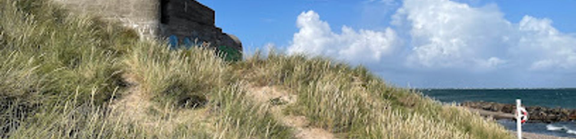
Dune Landscape Shaped by War
The Skagen Infantry Strongpoint lies in the soft, shifting dunes between Skagen town and the Grenen promontory, where the North Sea and the Kattegat collide. Here, pale sand, hardy beach grass and low, wind-pruned shrubs form a wide coastal belt threaded by sandy paths. Scattered through this seemingly natural scene are hulking concrete forms: bunkers half-buried in dunes, low observation posts and remnants of gun positions peering toward the sea. The contrast is part of the site’s fascination. From some angles you see only shorebirds, marram grass and changing light; from others, the stark geometry of reinforced concrete cuts through the landscape. Walking here, you move constantly between open views toward Grenen and more enclosed hollows, where the dunes shelter you from the ever-present wind.Atlantic Wall at Denmark’s Northern Tip
During the Second World War, German forces turned the northernmost point of Jutland into a fortified group of strongpoints guarding crucial sea lanes and air approaches. This position, sometimes referred to by the codename "Hamburg", was designed to protect a nearby radar station that monitored Allied movements along the coasts and across the Skagerrak and Kattegat. Construction of permanent bunkers began in 1942. Over time, the strongpoint grew into a dense complex of concrete positions, including more than twenty heavy bunkers with thick walls and roofs, as well as a similar number of lighter shelters and support structures. At its height, hundreds of soldiers were stationed here, forming a key link in the wider Atlantic Wall network that stretched along much of Europe’s western coastline.Bunkers Hidden and Exposed
Today, many of the bunkers in the eastern part of the area are clearly visible around the main access points and parking area. Their entrances, firing slits and ventilation shafts stand exposed, allowing you to sense their former function as shelters, command posts and firing positions. On the western side, however, the terrain becomes lower and wetter, and several installations are partly hidden by dunes and hollows, giving them an almost secretive character. As you explore, you might notice differences in design and size: squat infantry shelters, medical bunkers and more complex structures built to standardized German plans. Some interiors are accessible, though often dark, sandy and uneven underfoot, which adds to their atmosphere but also calls for care. The weathered concrete bears the marks of decades of salt air, with rust stains and lichen softening once-sharp edges.Skagen Bunker Museum and Interpretation
Near the strongpoint stands the Skagen Bunker Museum, housed in a former German hospital bunker of the Regelbau 638 type. Inside, recreated rooms with bunks, medical equipment and period objects help explain how the bunker network functioned as a living and working environment for the garrison during the war. Exhibits shed light on the broader history of Skagen under occupation, the strategic importance of this headland and the daily routines of soldiers stationed in such a remote, windswept outpost. Combined with the open-air remains scattered through the dunes, the museum provides valuable context, turning scattered concrete shells into parts of a larger defensive system and human story.Walking, Reflection and Sea Views
Visiting the strongpoint is as much about mood as about military detail. Footpaths lead through dunes scented with sea air, and at many points you can look north toward Grenen, where the waves of two seas meet in shifting patterns. The soundscape is dominated by wind, surf and seabirds, occasionally broken by voices echoing inside a bunker. It is a place that invites unhurried exploration and quiet reflection. You can climb modest dune ridges for higher viewpoints, step into the cool darkness of a bunker corridor, then emerge again into bright, often gusty light. Whether you are primarily interested in Second World War history or simply curious about how conflict leaves marks on a landscape, the Skagen Infantry Strongpoint offers a compact, evocative setting to experience both.Practical Visit and Seasonal Atmosphere
The area around the infantry strongpoint is generally open and unfenced, making it easy to combine a visit with a longer walk toward the tip of Grenen or the nearby lighthouse. Conditions change with the seasons: in summer the dunes can feel warm and inviting, with longer daylight hours and more people around, while in autumn and winter the wind intensifies, the light grows sharper and the site can feel strikingly remote. Loose sand, occasional wet patches and low steps into some bunkers mean that sturdy footwear is recommended. Weather can change quickly along this exposed coast, so layered clothing and wind protection are useful year-round. Simple information boards in the wider Skagen area help place the bunkers in context, but the real rewards come from taking time to explore the dunes, noticing how history, nature and the sea continue to shape this edge-of-Denmark landscape.Local tips
- Wear sturdy, closed shoes; paths are sandy and uneven, and bunker interiors can be dark, with low thresholds and scattered debris.
- Bring a windproof layer even in summer, as the exposed dunes between Skagen and Grenen are often breezy and can feel significantly cooler than in town.
- Combine your walk among the bunkers with a visit to the Skagen Bunker Museum for historical background on the Atlantic Wall and local wartime life.
- If entering bunkers, carry a small flashlight or use your phone light for steps and corners, and watch your head on low ceilings and doorways.
- In winter and shoulder seasons, check local information for museum opening hours and daylight times to make the most of coastal views and photography.
A brief summary to Skagen infanteristøttepunkt
- Unnamed Road, Skagen, 9990, DK
- Visit website
- Monday 12 am-12 am
- Tuesday 12 am-12 am
- Wednesday 12 am-12 am
- Thursday 12 am-12 am
- Friday 12 am-12 am
- Saturday 12 am-12 am
- Sunday 12 am-12 am
Getting There
-
Local bus from Skagen town
From central Skagen, take a regional bus toward Grenen and the lighthouse area; services typically run at least hourly in high season and less frequently off-season. The ride takes about 10–15 minutes, and a one-way adult ticket usually costs around 20–30 DKK. Expect limited evening departures, and be prepared for a short walk on sandy paths from the closest marked stop to reach the bunkers.
-
Bicycle from Skagen
Cycling from Skagen town to the infantry strongpoint follows established routes toward Grenen and generally takes 15–25 minutes at a relaxed pace. Standard bike rentals in Skagen often cost in the range of 100–150 DKK for a day. The route is mostly flat but can feel strenuous in strong headwinds, and you will need to park your bike near designated areas before continuing on foot into the dunes.
-
Car or camper from wider North Jutland
Arriving by car from elsewhere in North Jutland, follow main roads into Skagen and continue toward Grenen, where public parking areas serve both the lighthouse and bunker zone. Travel times range from about 45–60 minutes from Hirtshals or Frederikshavn. Parking is typically paid during the busier months, with fees often between 10 and 20 DKK per hour. Spaces can fill quickly in peak summer, and larger campers may be directed to specific sections.
-
On foot from Skagen town
If you enjoy walking, you can reach the strongpoint on foot from central Skagen in roughly 40–60 minutes, following established routes toward Grenen. The distance is suitable for reasonably fit visitors, but expect sections of firm sand and some softer dune paths closer to the bunkers. There is no entrance fee for the open-air site, though separate admission applies if you continue to the nearby Skagen Bunker Museum during its opening hours.


