From Eve
Know before you go
Hi, I'm Eve. Here are a few practical things to know before exploring Bull Head.
Local know-how to help you travel smarter and make the most of every moment.

Discover Jamaica's hidden gem: Hike to the geographical center of the island and experience breathtaking panoramic views from Bull Head Mountain.
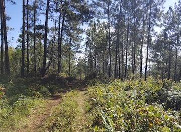
Bull Head Mountain, located in Clarendon, Jamaica, marks the island's geographical center and offers stunning panoramic views. Rising to 3,600 feet (1,097 meters), this mountain range is a popular hiking destination and the source of the Rio Minho, Jamaica's longest river. Its name derives from its resemblance to a bull's head when viewed from the sea.
Opening times, essentials, and a few local tips gathered into one calmer, easier-to-scan planning section.
Hi, I'm Eve. Here are a few practical things to know before exploring Bull Head.
Local know-how to help you travel smarter and make the most of every moment.
Driving
From Chapelton, take the road towards Pennants. Continue through several small districts. The road will become a dirt track as you approach the mountain. There is no official parking; park at the widest section of the road near the trailhead.
Walking
From the parking spot, follow the trail uphill. The trail is not well-marked, so a guide is recommended. The hike to the summit takes approximately 2-3 hours, depending on your fitness level. Be prepared for steep sections and muddy areas.
Use Bull Head as your starting point for nearby food, family ideas, nightlife, and more local discoveries.

Explore expert travel guides, compare and book tours, experiences, hotels, and more—all from the palm of your hand. Download now for seamless trip planning wherever your wanderlust takes you.

Discover the serene beauty and rich culture of St. Thomas Lowlands in Jamaica, a tranquil escape with unspoiled beaches, lush landscapes, and authentic local experiences.
Tell me more about St Thomas Lowlands