Discover the Majestic Pictured Rocks
Explore Pictured Rocks National Lakeshore, where breathtaking cliffs meet pristine waters in a stunning natural landscape.
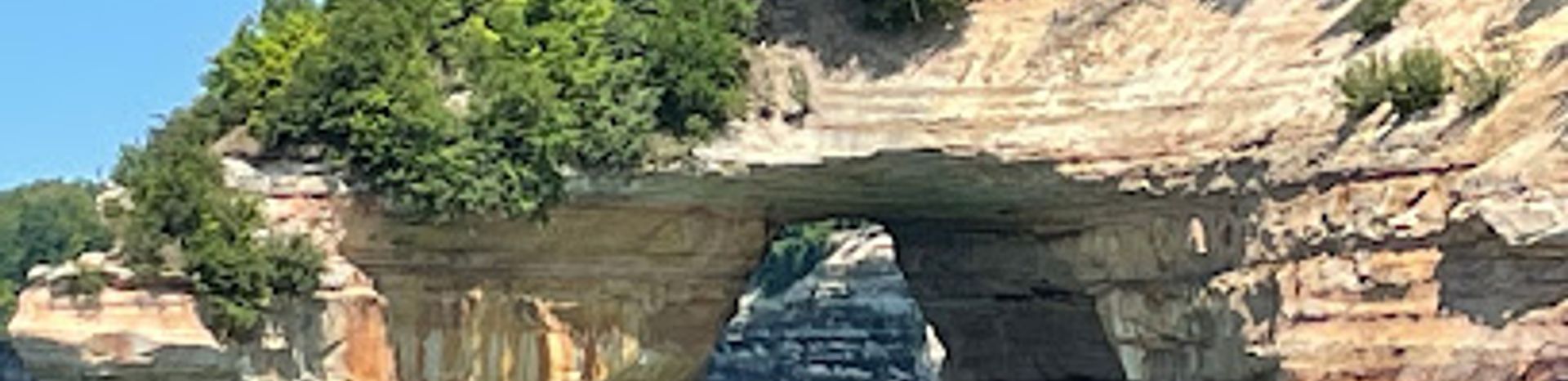
Pictured Rocks, located along the shores of Lake Superior in Michigan's Munising Township, is a stunning natural wonder that captivates visitors with its dramatic cliffs and vibrant colors. Stretching for 15 miles, this national lakeshore features sandstone cliffs that rise up to 200 feet above the water, showcasing an array of colors from deep reds and oranges to bright greens and blues, shaped by centuries of erosion. The unique rock formations, including arches, caves, and spires, provide a striking backdrop for hiking, kayaking, and photography. The area is rich in biodiversity, making it a haven for wildlife enthusiasts. The tranquil waters of Lake Superior invite visitors to explore by boat or take guided tours that reveal the majestic beauty of the cliffs from the water. Hiking trails wind through the lush forests surrounding the cliffs, offering various difficulty levels that cater to both casual walkers and seasoned hikers. The best time to visit is during the fall when the foliage adds a vibrant tapestry of colors to the landscape. Whether you're looking to enjoy a peaceful day surrounded by nature or seeking adventure, Pictured Rocks promises an unforgettable experience.
Local tips
- Visit during sunrise or sunset for the best lighting and breathtaking views of the cliffs.
- Bring a camera; the vibrant colors and unique formations are perfect for photography.
- Consider kayaking to see the cliffs from the water for a unique perspective.
- Check for ranger-led programs to learn more about the area's geology and ecology.
- Pack a picnic to enjoy at one of the scenic overlooks during your visit.
A brief summary to Pictured Rocks
- Munising Township, Michigan, US
Getting There
-
Car
If you're traveling by car, the most direct route to Pictured Rocks National Lakeshore is via M-28. From the nearest city of Munising, head east on Munising Avenue, which will lead you directly into the park entrance. The park entrance is well-marked and located at the coordinates 46.5333° N, 86.4882° W. You may need to pay an entrance fee, which is currently $15 per vehicle for a 7-day pass. Once inside, follow the signs toward the various scenic viewpoints and trails.
-
Public Transportation
For those relying on public transportation, your best option is to take a Greyhound bus to Munising, Michigan. The bus will drop you off at the Munising bus station. From there, you can take a local taxi or rideshare service to reach the entrance of Pictured Rocks National Lakeshore. Be sure to check the schedule in advance, as bus services may not run frequently. The taxi fare may vary but expect to pay around $10 to $15 for the short trip to the park entrance.
-
Biking
If you're interested in biking, once you reach Munising, you can rent a bike from a local rental shop. From Munising, you can bike along the scenic roads that lead to Pictured Rocks. The distance is approximately 10 miles, and the route will take you through beautiful landscapes. Make sure to wear a helmet and be prepared for some elevation changes along the way.
-
Walking
For adventurous travelers already in Munising, walking to Pictured Rocks can be an option. It is about a 10-mile walk, which would take around 3 to 4 hours. Start by heading northeast on Munising Avenue, and follow the signs to the park entrance. Ensure you have plenty of water and snacks, as well as appropriate footwear. Walking may not be feasible for everyone, so plan accordingly.


