Background

Enebærodde Lighthouse (Enebærodde Fyr)

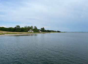
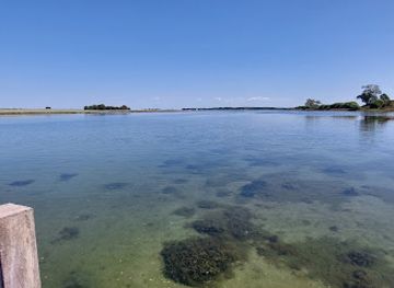
A modest white tower at the very tip of Enebærodde, where Odense Fjord meets the Kattegat and wide skies, strong currents and heathland create a wild coastal feel.

4.7

Lighthouse at the Edge of Odense Fjord

Enebærodde Lighthouse stands at the extreme tip of the long, narrow spit that separates Odense Fjord from the Kattegat, a white concrete tower clearly visible against sea and sky. From here you overlook the narrow channel known as Gabet, where the waters squeeze between the spit and the mainland. The landscape feels open and exposed, with low vegetation, sand, shingle and winds that often arrive straight off the Kattegat. The tower itself is relatively modest at around 14 metres high, but the flat surroundings make it a prominent landmark. Its simple, functional design reflects its purpose: to guide ships safely into the fjord and warn of the strong currents and shallows around the headland. From the outside you can see the lantern atop the tower and the neat proportions typical of late 19th‑century Danish lighthouses.

Signals, Ships and Seafaring History

Before the current lighthouse was completed in the 1890s, smaller lights had already been helping ships find the entrance to the fjord. Earlier beacons were installed and upgraded several times as maritime traffic increased, and eventually the national lighthouse authorities built the present structure, adding a more advanced lens system to project its beam far across the water. Later technological updates brought modern fuel systems and eventually electric power, changing the way the light was maintained but not its essential role. In the era when nearby shipyards launched large vessels, this narrow passage saw impressive traffic passing close by the spit. Standing by the tower today, it is easy to imagine big hulls sliding through the confined waters, relying on the fixed light and the leading lights across at Lodshuse to line up their approach. The lighthouse still operates as a navigational aid, even though its daily drama has quietened with changes in shipping.

Heathland, Wildlife and Protected Nature

Around the lighthouse, the Enebærodde spit forms one of Funen’s largest heath areas, with juniper bushes that inspired its name, patches of heather and open sandy stretches near the shore. The combination of salty winds, poor sandy soil and exposure shapes a low, tough plant community that can endure harsh coastal conditions. It is a place where skylarks, waders and seabirds are part of the soundscape, and seasonal light changes quickly as clouds move across the flat horizon. The broader spit is protected, and visitors are asked to stay on paths away from sensitive dunes and vegetation. Grazing cattle are sometimes used to maintain the heathland character, and you may see them at a distance as you make your way out. The sense of space and the mix of sea on both sides create a distinctive atmosphere, especially on clear days when you can see towards Fyns Hoved, Hindsholm and further along Odense Fjord.

Reaching the Lighthouse on Foot or by Bike

Enebærodde Lighthouse has no road access right to its base; instead, the approach itself is part of the experience. A well‑used coastal and dune‑edge path runs along the spit, suitable for a steady walk or a bike ride on relatively firm sand and tracks. The distance from the start of the spit to the tip makes it a rewarding outing, and you feel the lighthouse slowly growing larger on the horizon as you advance. Because the area is relatively exposed, wind direction and weather make a big difference to how the journey feels. On calm summer days the walk can be gentle and almost meditative, with soft surf on one side and the quieter fjord on the other. In cooler seasons or in strong winds it becomes more bracing and dramatic, with gusts, blowing sand and waves emphasising how isolated the headland really is.

What You Can See and Do at the Tip

There is no public access inside the lighthouse, and the former keeper’s house beside it is privately owned. The experience here is therefore about being outdoors: watching the currents race through the Gabet, scanning for birdlife, and absorbing the wide panorama of sea and coastline. The light constantly changes, and photographers often linger to capture shifting skies, silhouettes of the tower and reflected colours on the water. Bring something to sit on and treat the area around the lighthouse as an open‑air viewpoint. On still days you may hear the slap of waves and distant calls of birds more clearly than any human sound. The sense of arriving at the end of the spit is satisfying in itself, and many visitors choose to pause here for a simple picnic before retracing their route, taking in the alternating views of fjord and open sea on the way back.

Practical Considerations and Safety by the Water

The waters off the tip of Enebærodde are known for strong and complex currents, so this is not a suitable place for swimming despite the tempting shoreline. It is safest to enjoy the sea from the land and choose calmer, more sheltered beaches elsewhere for bathing. Footwear that copes with sand, pebbles and occasional puddles is helpful, and windproof layers make visits more comfortable for much of the year. Because there are no services at the lighthouse itself, you should bring drinking water and any snacks you need. Rubbish must be taken back with you, as the area’s protection depends on low impact from visitors. Dogs, if present, should be kept under close control and on a lead to avoid disturbing wildlife and any grazing animals in the wider spit. With a little preparation, the walk to Enebærodde Lighthouse becomes a memorable small expedition to one of North Funen’s most distinctive coastal landmarks.

Local tips

  • Wear sturdy shoes and windproof layers; the walk along the spit is exposed, sandy and can feel much longer in strong onshore winds.
  • Bring water and snacks, as there are no facilities at the lighthouse or along the outer part of the spit, and take all rubbish back with you.
  • Respect safety signs and avoid swimming near the tip of Enebærodde; currents around the Gabet are strong and can be dangerous.
  • Keep to marked paths to protect the heath and dunes, and keep dogs on a lead, especially if grazing cattle are present in the area.
widget icon

Buy tickets

    No tickets available

Book tours with entry

    No tours available

Book tours without entry

    No tours available

A brief summary to Enebærodde Fyr

Getting There

  • Car plus walk

    From Otterup, drive towards Hasmark and follow local signs for Enebærodde; the trip takes about 15–25 minutes depending on traffic. Parking is typically free near the start of the spit, but spaces can fill on sunny weekends. From the parking area you continue on foot or by bike along the coastal path for roughly 5–7 km to reach the lighthouse, allowing 1.5–2.5 hours each way at a relaxed walking pace.

  • Local bus and walk

    From Odense, take a regional bus towards Otterup, usually 30–45 minutes, for a fare in the range of 30–60 DKK depending on ticket type. From Otterup you can continue by taxi or cycle hire towards the Enebærodde trailhead, then walk the final 5–7 km along the spit to the lighthouse. Buses run less frequently in evenings and on weekends, so check times in advance and plan extra time for the walk.

  • Cycling from nearby villages

    Enebærodde works well as a day trip by bike from Otterup or Hasmark, typically 30–60 minutes of cycling on mostly flat roads to the beginning of the spit. There is no fee to access the nature area, but you must be comfortable riding on shared roads and then continuing on sandy and sometimes uneven paths along the spit. In wet or windy conditions the route can feel more demanding, so allow a flexible schedule and bring lights if returning late.

Popular Experiences near Enebærodde Fyr

Popular Hotels near Enebærodde Fyr

Select Currency