Enebærodde
A pristine coastal peninsula where Denmark's largest heath meets the fjord—nature in its purest form.
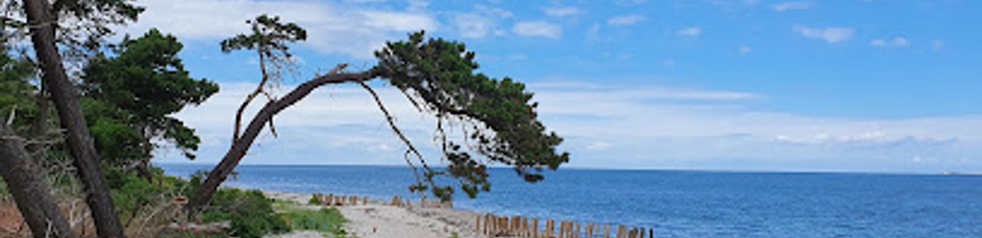
Enebærodde is a stunning 5.5-kilometer-long peninsula jutting into the waters between Kattegat and Odense Fjord in North Funen, Denmark. This 300-hectare conservation area features Denmark's largest heath landscape, pristine sandy beaches, and panoramic views across the fjord. Accessible only on foot or by bicycle, it offers peaceful hiking and cycling trails through juniper-dotted heathland, isolated coves, and coastal paths. The protected natural environment supports diverse wildlife and provides a serene escape for nature lovers seeking solitude and scenic beauty.
A brief summary to Enebærodde
- Halshusene 45, Otterup, 5450, DK
- +4564812044
- Visit website
- Duration: 2 to 5 hours
- Free
-
 Outdoor
- Mobile reception: 3 out of 5
Local tips
- Visit during spring or early autumn for the most pleasant weather and fewer crowds. The heathland displays beautiful colors in late summer and early autumn.
- Bring a packed lunch or thermos—there are no facilities on the peninsula, but numerous scenic spots make perfect picnic locations with views across the fjord.
- Keep dogs on leash at all times and maintain distance from Galloway cattle, especially calves. The animals can become stressed by loose dogs, creating safety risks.
- Avoid swimming at the peninsula's tip where strong currents are dangerous. Stick to the beaches along the sides for safe swimming.
- Plan for at least 2–3 hours to fully experience the trails and beaches. A complete circuit takes approximately 4–5 hours at a leisurely pace.
For the on-the-go comforts that matter to you
- Picnic Areas
- Trash Bins
- Information Boards
Getting There
-
Car from Otterup
Drive from Otterup town center (approximately 10 kilometers) toward Hasmark via local roads. Follow signs for Enebærodde or Hasmark. The journey takes 15–20 minutes. Parking is available at the Hasmark area near the peninsula entrance. No entrance fee is charged, but parking may have nominal costs depending on the facility.
-
Bicycle from Otterup
Cycle from Otterup via regional cycling routes toward Hasmark, approximately 12–15 kilometers depending on the route chosen. The journey takes 45–60 minutes on relatively flat terrain. Dedicated cycling paths connect Otterup to the Enebærodde area. Bicycles are permitted on all trails within the peninsula.
-
Public Transport and Walking
Take local buses from Otterup toward Hasmark or surrounding towns. Service frequency varies seasonally; check regional transport schedules in advance. From the nearest bus stop, walk 1–3 kilometers to the peninsula entrance depending on the stop. Total journey time is typically 45–90 minutes including waiting time.
-
Organized Tour
Several local tour operators in North Funen offer guided visits to Enebærodde, typically including transportation from nearby towns. Tours range from 3–5 hours and cost approximately 300–500 Danish kroner per person. Contact VisitNordfyn for current tour availability and booking information.
Enebærodde location weather suitability
-
 Any Weather
-
 Clear Skies
-
 Mild Temperatures
Discover more about Enebærodde
A Unique Spit Between Two Waters
Enebærodde is a remarkable geographical formation—a narrow peninsula that stretches 5.5 kilometers into the waters separating Kattegat from Odense Fjord. At its narrowest point, the spit measures just 20 meters wide, while at its widest it expands to 750 meters. This dramatic landscape creates a distinctive silhouette visible from across the fjord and has shaped the ecology and character of the entire region. The peninsula covers 300 hectares and represents one of North Funen's most distinctive natural landmarks, drawing visitors seeking authentic coastal wilderness.Denmark's Largest Heath Landscape
Enebærodde contains Funen's only considerable heath—a rare and protected ecosystem that has largely disappeared from the Danish landscape. The heath is characterized by rolling terrain dotted with juniper bushes, which gave the peninsula its name (Enebær translates to juniper berry). This unique vegetation creates a distinctive aesthetic throughout the year, from the soft greens of spring to the golden and purple hues of autumn. The protected status ensures that this fragile ecosystem remains undisturbed, allowing native plants and wildlife to thrive in their natural state. Walking through the heathland offers visitors a glimpse of Denmark's historical landscape before modern agriculture transformed much of the countryside.Trails and Coastal Pathways
A comprehensive network of well-maintained trails circles the entire peninsula, with approximately 12 kilometers of marked routes available for hiking and cycling. The coastal path runs along the shoreline, offering constantly changing perspectives of the fjord and surrounding islands. Trails wind through heathland, past sheltered woods, and along pristine beaches, accommodating various fitness levels and preferences. The terrain is generally accessible, with mostly level or gently rolling paths suitable for families and casual walkers, though some sections traverse natural surfaces. Cyclists find the routes equally rewarding, with dedicated cycling paths providing an efficient way to explore the broader landscape while maintaining intimate contact with the natural environment.Beaches and Water Views
Enebærodde boasts several sandy beaches where visitors can relax, swim, and enjoy the water. The beaches range from sheltered coves to more exposed stretches, each offering distinct character and views. From the peninsula's tip, visitors enjoy sweeping vistas across Odense Fjord toward Hindsholm and distant views of the island of Samsø. However, swimmers must exercise caution at the peninsula's tip, where strong currents make the water dangerous. The beaches themselves provide safe swimming opportunities and excellent spots for picnicking, fishing, and simply absorbing the coastal atmosphere. Many visitors bring packed lunches to enjoy while gazing across the water, making the beaches ideal for extended stays.Protected Status and Conservation Rules
Enebærodde has been a protected conservation area since 1988, when 296 acres were formally designated. The area is privately owned, and strict rules govern visitor access to preserve its ecological integrity. Access to the trails is permitted only between 6 AM and sunset, though the beaches themselves remain accessible throughout the day and night. All visitors must remain on designated trails, and bicycles are permitted alongside pedestrians. Dogs are welcome but must remain on leash at all times, as they can stress the Galloway cattle that graze in parts of the peninsula. These regulations reflect a commitment to balancing public access with environmental protection, ensuring that Enebærodde remains pristine for future generations.Wildlife and Natural Diversity
The peninsula supports a rich variety of flora and fauna adapted to its unique coastal heath environment. Beyond the distinctive juniper bushes, visitors may encounter diverse bird species, particularly during migration seasons. The Galloway cattle that inhabit portions of the area play an ecological role in maintaining the heath landscape through grazing. The protected status has allowed populations of rare insects, including specialized butterfly and moth species, to establish themselves. The fjord waters surrounding the peninsula support fish populations that attract anglers, while the coastal environment provides habitat for seabirds and marine life. This ecological richness makes Enebærodde valuable for both conservation and nature observation.For the vibe & atmosphere seeker
- Tranquil
- Scenic
- Adventurous
- Nature Escape
For the design and aesthetic lover
- Rustic Designs
For the architecture buff
- Parks & Gardens
- Viewpoints
- Heritage Neighborhoods
For the view chaser and sunset hunter
- Panoramas
- Waterfront
- Iconic Views
- Sunset Spots
For the social media creator & influencer
- Photo Spots
- Instagrammable
- Scenic Backdrops
For the eco-conscious traveler
- Protected Area
- Nature Reserve
- Eco-Friendly
- Leave-No-Trace Critical
- Locally Managed
- Wildlife Habitat
For the kind of experience you’re after
- Nature Escape
- Photowalk
- Day Trip
- Cultural Heritage
For how adventurous you want the journey to be
- Easy Access
- Requires Hike
Location Audience
- Family Friendly
- Solo Friendly
- Couple Friendly
- Senior Friendly
- Pet Friendly


