

Kagoro Hills Travel Guide - Free Web & App
Your ultimate guide to Kagoro Hills. Discover top landmarks, proposed trips, and local tips. Free on the web or via the Evendo companion app.


Kagoro Hills in Nigeria offer granite ridges, forested hills, cultural heritage and walking near Kaduna State, with scenic highland escapes and local traditions.
Landscape and Setting
Kagoro Hills rise above the town of Kagoro in Kaura Local Government Area of Kaduna State, in Nigeria's southern Kaduna highlands. The landscape is defined by rugged granite outcrops, wooded slopes, steep-sided ridges and broad views across a greener, cooler-looking part of the country than the more open savannah farther north. The hills are not a single enclosed national park but a natural and cultural landscape closely associated with Kagoro and surrounding settlements. Their appeal lies in the combination of exposed rock, forested valleys, rural scenery and the distinctive presence of the highlands in local life.Read more about Kagoro Hills
People, History and Culture
Exploring the Hills
When is the best time to visit Kagoro Hills?
Best: December–February · 30–31°C| Month | High (°C) | Rainfall (mm) |
|---|---|---|
| January (best) | 30 | 2 |
| February (best) | 31 | 1 |
| March | 31 | 1 |
| April | 31 | 1 |
| May | 32 | 1 |
| June | 32 | 1 |
| July | 32 | 1 |
| August | 32 | 1 |
| September | 32 | 1 |
| October | 32 | 1 |
| November | 31 | 1 |
| December (best) | 31 | 1 |
Getting to and around Kagoro Hills
How to get there
Transportation
Best landmarks in Kagoro Hills
The defining landmarks of the area are the granite ridges and rocky summits of Kagoro Hills, which rise visibly above the surrounding cultivated landscape and provide the destination's strongest geographical identity. Their significance is both physical and cultural: the formations are products of the ancient crystalline highlands, while the hills remain closely associated with Kagoro and the Gworok homeland. The town of Kagoro is an important human landmark in its own right, linking traditional institutions, settlement and rural life with the uplands behind it. Across the wider approach, wooded slopes, exposed boulders, valley farms and distant highland views form a sequence of recognisable landscape features rather than isolated monuments. There is no need to expect castles, formal museum precincts or heavily developed viewpoints; the value of Kagoro Hills lies in the relationship between rock, vegetation, settlement and community memory.
-
Tourist attraction
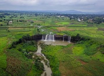
Matsirga Attat Waterfalls
Explore the enchanting Matsirga Attat Waterfalls in Kafanchan, Kaduna – a hidden gem of nature's beauty and cultural richness.
Explore Kagoro Hills on the map
Plan your trip on one map. See where the top attractions, landmarks, restaurants and hotels are, and book hotels and experiences in a few clicks.
Best hotels in Kagoro Hills
Best restaurants in Kagoro Hills
Dining around Kagoro Hills is modest and concentrated in Kagoro, Kafanchan and other larger settlements rather than on the hilltops. Visitors can expect simple Nigerian meals, local staples and refreshments from small eateries, food sellers and accommodation kitchens, with menus varying by place and season. Regional food commonly reflects the grain, tuber, vegetable and legume agriculture of the Middle Belt, while grilled meats, soups, rice dishes and other familiar Nigerian preparations may be available in town. Kafanchan generally offers a broader choice of established restaurants and provisions than rural Kagoro. Anyone heading out for a walk should buy drinking water and food beforehand, and should not assume that a remote viewpoint has a café, shop or reliable supply of refreshments. A guide or host can help identify reputable local places and explain customary ways of ordering and payment.
-
Restaurant
Garassa Food Castle
Experience the vibrant culinary scene at Garassa Food Castle in Kafanchan Junction - where local flavors meet international delights.
-
Restaurant
Blessed Food Restaurant
Experience authentic Nigerian cuisine at Blessed Food Restaurant in Kafanchan – where every meal tells a story!
-
Fast Food
Abbie's Kitchen Delight
Discover the authentic tastes of Nigeria at Abbie's Kitchen Delight in Kafanchan - a fast food haven for culinary enthusiasts.
-
Restaurant
Sunny Restaurant
Experience authentic Nigerian cuisine at Sunny Restaurant in Kafanchan, where every meal tells a story of rich cultural heritage.


Best bars in Kagoro Hills
Kagoro Hills is a quiet rural destination rather than a nightlife centre. Evening activity in Kagoro is likely to focus on conversation, local hospitality and modest restaurants or drinking places, while Kafanchan provides a wider selection of informal bars and evening venues for visitors staying in the regional town. Entertainment is generally low-key and dependent on the day, season and local circumstances; this is not an area to visit expecting a concentrated club district, late-night programme or reliable live-music circuit. Visitors should follow local security advice, avoid wandering through unfamiliar areas after dark and arrange transport back to their accommodation in advance. Community celebrations and cultural occasions may bring music and social gatherings, but their timing and accessibility should be confirmed locally rather than assumed.
-
Bar
Bilhat Gardens & Bar
Experience the serene beauty of Bilhat Gardens & Bar in Kafanchan, Kaduna, where nature and nightlife come together for a memorable outing.
-
Bar
Mitro Bar
Mitro Bar in Kafanchan: A lively hub for drinks, local cuisine, and vibrant nightlife in Kaduna, perfect for socializing and relaxation.
Get your free copy of our complete guide to Kagoro Hills, delivered straight to you.
Everything on this page, from attractions and restaurants to essentials and local phrases, in one PDF you can read offline, print or share.
Already have an account? Sign in
Your Kagoro Hills guide is ready.
We'll send it to · Not you? Sign out

Getting your guide ready…
We are putting together a fresh copy of the Kagoro Hills guide. This can take up to a minute.
This can take a few moments. If your browser asks, choose Allow so the download can start. You'll find the guide in your Downloads folder.
Nothing happened? Download it again
Sorry, the guide is taking longer than usual. Please try again in a minute, or get it by email instead.
Kagoro Hills essentials
Currency and Payment
Safety
Emergency Situations
Do's and Don'ts
Local Tips
From Eve
Local phrases worth knowing
You don't need to get them perfect. A few words go a long way, and locals appreciate the effort.
Basics
| English | Local | Say it |
|---|---|---|
| Hello | Yakwai | [yah-kwai] |
| Goodbye | Sai wata rana | [sigh wah-tah rah-nah] |
| Yes | Eh | [eh] |
| No | A'a | [ah-ah] |
| Please/You're welcome | Da so | [dah soh] |
| Thank you | Na gode | [nah goh-deh] |
| Excuse me/Sorry | Zan tafi | [zahn tah-fee] |
| How are you? | Yaya ka ke? | [yah-yah kah kay] |
| Fine. And you? | Yaya. Kana yaya? | [yah-yah. kah-nah yah-yah] |
| Do you speak English? | Ka fada turanci? | [kah fah-dah too-rahn-chee] |
| I don't understand | Ban sani ba | [bahn sah-nee bah] |
Eating & Drinking
| English | Local | Say it |
|---|---|---|
| I'd like to see the menu, please | Zan iya duba menu, don Allah | [zahn ee-yah doo-bah meh-noo, dohn ah-lah] |
| I don't eat meat | Ban jin nama | [bahn jeen nah-mah] |
| Cheers! | Aikin sa | [eye-keen sah] |
| I would like to pay, please | Zan bada kuwa, don Allah | [zahn bah-dah koo-wah, dohn ah-lah] |
Emergencies
| English | Local | Say it |
|---|---|---|
| Help! | Taimaki! | [tai-mah-kee] |
| Go away! | Jin hawaye! | [jeen hah-wah-yeh] |
| Call the Police! | Ka kira karamar hukumar | [kah kee-rah kah-rah-mahr hoo-koo-mahr] |
| Call a doctor! | Ka kira dokinta! | [kah kee-rah doh-keen-tah] |
| I'm lost | Na yi gudu | [nah yi goo-doo] |
| I'm ill | Na yi yawa | [nah yi yah-wah] |
Shopping
| English | Local | Say it |
|---|---|---|
| I'd like to buy... | Zan samu... | [zahn sah-moo] |
| I'm just looking | Ina so na duba | [ee-nah soh nah doo-bah] |
| How much is it? | Shi ne anfi? | [shee neh ahn-fee] |
| That's too expensive | Wani abu ne mafi girma | [wah-nee ah-boo neh mah-fee geer-mah] |
| Can you lower the price? | Zaka iya kasa mafita? | [zah-kah ee-yah kah-sah mah-fee-tah] |
Time & Numbers
| English | Local | Say it |
|---|---|---|
| What time is it? | Yaya lokaci ne? | [yah-yah loh-kah-chee neh] |
| It's one o'clock | An bude bakwai | [ahn boo-deh bah-kwai] |
| Half past (10) | Da rabi (goma) | [dah rah-bee goh-mah] |
| Morning | Safe | [sah-feh] |
| Afternoon | Rana | [rah-nah] |
| Evening | Yamma | [yahm-mah] |
| Yesterday | Jibi | [jee-bee] |
| Today | Yau | [yah-oo] |
| Tomorrow | Gobe | [goh-beh] |
| 1 | Daya | [dah-yah] |
| 2 | Biyu | [bee-yoo] |
| 3 | Uku | [oo-koo] |
| 4 | Huɗu | [hoo-doo] |
| 5 | Biɗa | [bee-dah] |
| 6 | Shida | [shee-dah] |
| 7 | Bakwai | [bah-kwai] |
| 8 | Takwas | [tah-kwahs] |
| 9 | Tara | [tah-rah] |
| 10 | Goma | [goh-mah] |
Transport & Directions
| English | Local | Say it |
|---|---|---|
| Where's a/the...? | Ina...? | [ee-nah...?] |
| What's the address? | Yaya adireshin ne? | [yah-yah ah-dee-reh-sheen neh] |
| Can you show me (on the map)? | Zaka iya nuna min (a cikin ramani)? | [zah-kah ee-yah noo-nah meen (ah chee-keen rah-mah-nee)?] |
| When's the next (bus)? | Yaya lokaci ne na dawo (motar)? | [yah-yah loh-kah-chee neh nah dah-waw (moh-tahr)?] |
| A ticket (to ....) | Tikiti (zuwa ....) | [tee-kee-tee (zoo-wah ....)] |
History of Kagoro Hills
A Granite Highland Landscape
The hills form part of the crystalline highland terrain of southern Kaduna, where resistant granite and related basement rocks create prominent ridges and rocky eminences above the surrounding countryside. Their present appearance reflects long geological weathering and erosion rather than a single recent event. Valleys, soils and seasonal streams have supported cultivation around the uplands, while the rock formations have provided the visual framework for the identity of Kagoro. Geological history is therefore fundamental to understanding the destination, although the hills themselves are also a lived-in cultural landscape rather than an empty wilderness.
The Kagoro Homeland
Kagoro is associated with the Gworok, or Kagoro, people, whose traditional homeland occupies part of southern Kaduna. As elsewhere in the region, settlement developed around access to cultivable land, water and defensible or easily recognised high ground. Farming, household production and local exchange shaped relationships between villages and the surrounding hills. Traditional leadership and community institutions remain important to local identity, and visitors should understand that the landscape includes privately used farms, settlements and culturally meaningful places rather than being solely a recreational area.
Colonial and Regional Change
During the colonial period, southern Kaduna was incorporated into the administrative systems and transport networks of Northern Nigeria, bringing new forms of taxation, mission activity, schooling and political administration alongside existing communities and institutions. Later regional development connected Kagoro more closely with towns such as Kafanchan and Kaduna, although the hills have not developed the dense tourism infrastructure found at Nigeria's major resort destinations. The area's history is consequently best read through its settlements, traditional authorities, religious communities, farming patterns and changing road connections.
Cultural Continuity and Contemporary Tourism
Kagoro's hills continue to function as a local geographical reference and a setting for landscape-based recreation, cultural interest and community life. Modern visitors generally encounter a rural highland environment where tourism remains modest and locally dependent. Conservation is expressed less through a single widely known protected-area structure than through the need to respect farms, vegetation, rock sites and community access arrangements. The future visitor experience will depend on responsible travel, accurate local guidance and development that benefits residents without treating the hills as an unoccupied backdrop.
Kagoro Hills in Photos
Browse through our photo collection highlighting the charm and character of the destination.
Neighbouring destination travel guides
The closest destinations to Kagoro Hills, if you have time for more than one.
-

-
 Kajuru Castle
 in Nigeria offers medieval-style architecture, hilltop views, Kaduna heritage and a distinctive rural escape near Kaduna city for curious visitors.
Kajuru Castle
Kajuru Castle in Nigeria offers medieval-style architecture, hilltop views, Kaduna heritage and a distinctive rural escape near Kaduna city for curious visitors.
-

-

-


Swipe for more destinations
Explore more

Explore more of North Central
Explore North Central Nigeria for Abuja's hills, Jos's plateau landscapes, Lokoja's river confluence, craft traditions and diverse inland foodways.
Explore North Central
Explore more of Nigeria
Discover Nigeria: A Land of Vibrant Cultures, Stunning Landscapes, and Rich History in the Heart of Africa.
Explore Nigeria