
London loop, London Travel Guide
A signed orbital walk through outer London, where riverside paths, marsh edges, parks, and suburban green corridors replace the usual city landmarks.
The London Loop is not a single sight but a signed long-distance walking route circling Greater London in sections. Near Erith, it threads through riverside paths, parks, woods, marsh edges, and suburban green corridors, with flat ground and a calm, low-key feel. Most visitors tackle a section rather than the full circuit, using stations and bus links to build a half-day or full-day walk.
A brief summary to London loop
- Dartford, Erith, DA8 2NF, GB
- Duration: 1 to 8 hours
- Free
-
 Outdoor
- Mobile reception: 4 out of 5

Know before you go
Hi, I'm Eve. Here are a few practical things to know before exploring London loop.
- Treat it as a section walk: choose a station-to-station stretch or a loop with clear exit points rather than trying to cover the full route.
- Wear shoes that can handle mud and uneven ground, especially after rain or in winter when riverside and field-edge paths slow down.
- Carry water and snacks, as facilities are patchy and often concentrated near transport hubs rather than along the quieter stretches.
Do you manage this location?
Take control to get all the benefits, like improved information, better appearance, and stronger visibility across AI-powered discovery. Learn more about listing your business on Evendo
Activate your presenceOther nearby places you may find interesting
The closest places of the same kind, if this one is not quite what you had in mind.



Explore London loop on the Map
A handpicked selection of must-see spots near London loop, mapped for you.
Getting There
-
Train
Use rail to reach Erith or nearby stations, then walk to a chosen access point. From central London, the journey is typically around 30 to 50 minutes depending on origin and service.
-
Bus
Local TfL buses can work well for access and exit points in the Erith corridor, especially if you are linking a shorter section walk with public transport.
-
On Foot
The route is designed for walking, and many visitors join it directly from a station or nearby neighbourhood. This is the most practical way to experience it.
-
Car
Driving is possible only as a support strategy, not the best primary approach. Parking can be limited near busy access points, and one-way logistics are awkward.
For the on-the-go comforts that matter to you
-
 Restrooms
-
 Drink Options
-
 Food Options
-
 Seating Areas
-
 Sheltered Areas
-
 Trash Bins
-
 Information Boards
Discover more about London loop
What it is
The London Loop is Greater London’s outer orbital walking route, designed as a chain of connected sections rather than one continuous day out. In the Erith area, it follows the Thames corridor and nearby tributaries, linking public footpaths, parks, woods, open ground, and stretches of suburban edge. It is best understood as an urban nature trail: long, practical, and varied, with the emphasis on walking rather than sightseeing in the conventional sense.What the walk feels like
The experience is calm and unforced. You move from riverside paths to field edges, then into wooded patches or parkland before crossing short built-up links between greener stretches. The terrain is mostly flat, though surfaces can change quickly from paved paths to mud, grass, or uneven ground. There are few dramatic landmarks; the appeal lies in the rhythm of the route, the open sky, the water, and the way outer London gradually shifts from residential edges to marshy and river-influenced landscapes. On a dry day it feels spacious and easygoing. After rain, some sections slow down noticeably and demand sturdier footwear.Why travellers use it
People come here for a walk that feels local but still expansive. It suits ramblers, fitness walkers, photographers, and visitors who want a day outdoors without leaving the city. The route works well in sections, so you can choose a short out-and-back, a circular variation, or a longer linear walk linked to rail stations. It is also useful as a way to read the geography of outer London: flood-control structures, river corridors, parks, and suburban margins all appear in the same walk. That gives the route a quiet cultural value, even when there is no single historic building to anchor the visit.Practical expectations
This is a free, self-guided walking route with mixed access conditions. Public transport is the most realistic way in and out, especially via Erith or nearby stations, and the route is not designed as a drive-to attraction. Facilities vary by section: toilets, seating, food, and shelter may be available near stations or park entrances, but they are not guaranteed along the whole line. The best time to walk is in mild, dry weather, especially in spring and early autumn. Weekends are busier, while weekday mornings are often quiet enough for a more solitary walk. The route rewards patience and planning more than impulse visits, and it is strongest when treated as a sectioned day walk rather than a quick stop.












Your all‑in‑one travel companion app
Explore expert travel guides, compare and book tours, experiences, hotels, and more—all from the palm of your hand. Download now for seamless trip planning wherever your wanderlust takes you.


Explore More of London

Looking beyond London loop? Discover London for broader travel guides, local hot-spots, and regional highlights.
Explore London
Discover over 250 shops, dining, and family fun at Lakeside Shopping Centre—West Thurrock’s vibrant retail and leisure hub.
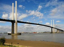
Discover Dartford Crossing, a stunning bridge over the River Thames, connecting Kent and Essex, and offering breathtaking views for all visitors.