Background

Leithen Water: The Swift Tributary Shaping Innerleithen

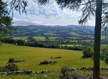
Discover Leithen Water, the swift, clear river that shapes Innerleithen’s landscape, heritage, and community spirit in the Scottish Borders.

★★★★★5 (3)

Leithen Water is a clear, cool tributary of the River Tweed flowing through Innerleithen in the Scottish Borders. Rising in the Moorfoot Hills, this fast-flowing river is beloved locally for its natural beauty, historic stone bridge, and recreational opportunities like wading and riverside walks. Its name, meaning 'grey' in Celtic, reflects the river’s character and cultural ties to the region.

Plan your visit

A brief summary to Leithen Water

Opening times, essentials, and a few local tips gathered into one calmer, easier-to-scan planning section.

Plan your visit

📍
Innerleithen, GB
🕒
Duration: 0.5 to 2 hours
💷
Free
🏛
Outdoor
📶
Mobile reception: 4 out of 5

Explore places near Leithen Water

    See all →

    Unlock the Best of Leithen Water

    Find tickets, tours with entry, and experiences available for this location.

    Buy tickets

    No tickets available

    Book tours with entry

    No tours with entry available

    Book tours without entry

    No tours without entry available

    Getting There

    Bus

    Regular bus services connect Innerleithen to nearby towns like Peebles and Galashiels, with travel times ranging from 20 to 40 minutes. Bus stops are within walking distance of Leithen Water. Tickets cost approximately £3–£6 one way.

    Car

    Driving to Innerleithen from Edinburgh or Peebles takes about 40 to 60 minutes via A72 and A707. Parking is available near Leithen Road, but spaces can be limited during peak times. No parking fees typically apply.

    Walking

    For visitors staying in Innerleithen, the riverside paths along Leithen Water are accessible on foot with easy terrain. Walking from the town center to the river takes about 10 to 15 minutes over mostly flat ground.

    For the on-the-go comforts that matter to you

    Seating Areas
    Information Boards
    Trash Bins

    Local tips

    Visit during summer to enjoy wading and ‘guddling’ fish in the shallow, clear waters popular with local children.
    Explore the riverside walking trails for peaceful woodland scenery and views of the historic Leithen Bridge.
    Bring waterproof footwear if walking after heavy rain, as some riverside paths may be muddy or partially flooded.
    Learn about the river’s cultural significance by visiting local heritage sites and community woodlands along its banks.

    Leithen Water location weather suitability

    Catch the right light and the right mood, whether you want a bright city moment or a more cinematic evening visit.

    Weather icon
    Any Weather
    Weather icon
    Rain / Wet Weather
    Weather icon
    Clear Skies
    Weather icon
    Mild Temperatures

    Discover more about Leithen Water

    Origins and Natural Character

    Leithen Water begins its journey in the rugged Moorfoot Hills, a range known for its moorland landscapes and forestry plantations. From these uplands, the river gathers strength quickly, fed by tributaries like the Bowbeat Burn, and flows rapidly towards Innerleithen. Its waters are generally cool and clear, though heavy rains can turn it murky. The river’s name, derived from a Celtic word meaning 'grey,' evokes the subtle hues of its flowing waters as they traverse the landscape.

    Connection to Innerleithen’s Identity

    The town of Innerleithen owes its very name to this river, with 'Inner' stemming from the Gaelic 'inbhir,' meaning confluence, highlighting the meeting point of Leithen Water and the River Tweed. This confluence has shaped the town’s development and local culture. The river is a focal point for community life, where children traditionally wade, catch fish by hand, and build small dams in summer, especially near landmarks like the Cauld fish ladder and the historic Leithen Bridge.

    Historic and Architectural Highlights

    A notable feature spanning the river is the Leithen Bridge, an elegant stone structure erected in 1799. Funded to facilitate easier access for townsfolk attending church, the bridge is a testament to local heritage and craftsmanship. Nearby, the riverbanks are lined with well-kept gardens and community woodlands, offering scenic spots that blend natural beauty with human touch, including the community-managed 'The Backs' woodland.

    Recreation and Riverside Walks

    Leithen Water is a popular site for gentle outdoor activities. The riverside walk circuits offer peaceful woodland paths and views of the river’s lively flow, making it a favored route for locals and visitors alike. These trails pass through diverse environments, from natural woodlands to golf course edges, showcasing the river’s role as a natural artery within the town. Birdlife such as grey wagtails and pheasants enrich the experience, while the river’s fast flow provides a dynamic backdrop.

    Environmental and Seasonal Dynamics

    The river’s temperament changes with the seasons. Normally tranquil, it can become a powerful force during spates, with notable floods recorded in 1949, 2002, and 2005. The surrounding forestry plantations, established in the 1970s, influence the river’s flow and ecology. The area’s windfarm on Bowbeat Hill adds a modern energy element to this ancient landscape, visible from afar and symbolizing a blend of natural and human forces.

    Cultural Resonance and Local Lore

    Leithen Water has inspired cultural references, including lending its name to Sir Edward Leithen, a character in John Buchan’s novels. The river’s presence is woven into the fabric of local stories and traditions, reflecting its enduring significance beyond just a geographical feature. It remains a cherished natural landmark, embodying the spirit and history of Innerleithen and the Scottish Borders region.

    A brief summary to Leithen Water

    Use Tower Bridge as your starting point for nearby food, family ideas, nightlife, and more local discoveries.

    Plan around the quieter times

    A quick look at seasonal patterns and peak visiting hours.

    Busiest months of the year

    Seasonality

    Busiest hours of the day

    Footfall
    Mobile App
    Get the app

    Your all‑in‑one travel companion app

    Explore expert travel guides, compare and book tours, experiences, hotels, and more—all from the palm of your hand. Download now for seamless trip planning wherever your wanderlust takes you.

    File:SCO-Peebles High Street 2018.jpg - Wikimedia Commons

    More about Peeblesshire

    Discover the serene beauty of Peeblesshire in the Scottish Borders, where history, nature, and local charm come together for an unforgettable experience.

    Tell me more about Peeblesshire

    Select Currency

    Choose the currency you want prices to display in.