From Eve
Know before you go
Hi, I'm Eve. Here are a few practical things to know before exploring Sunset Trail.
Local know-how to help you travel smarter and make the most of every moment.

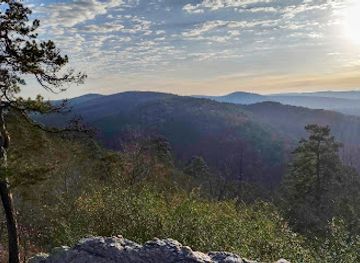
Hike the longest trail in Hot Springs National Park, exploring diverse terrains and scenic vistas on this 10-mile adventure.
Sunset Trail, the longest in Hot Springs National Park, offers a challenging yet rewarding hike through diverse terrains and remote areas. This 10-mile (one-way) trail immerses hikers in the natural beauty surrounding the historic spa city, with options to explore shorter sections or combine it with other trails for a longer loop.
Opening times, essentials, and a few local tips gathered into one calmer, easier-to-scan planning section.
Hi, I'm Eve. Here are a few practical things to know before exploring Sunset Trail.
Local know-how to help you travel smarter and make the most of every moment.
Walking
From the Fordyce Bathhouse Visitor Center, head west on Central Avenue. Turn left onto Reserve Street, then right onto Hot Springs Mountain Drive. Follow the road to the West Mountain Summit, where you can access the Sunset Trailhead. Parking is available at the summit. No fees are required to access the trail.
Public Transport
From downtown Hot Springs, take the City Cab bus Route 1 towards West Mountain. Get off at the West Mountain Summit stop. From there, the Sunset Trailhead is a short walk away. A single ride fare is $1.25 [https://www.cityofhs.org/departments/transit].
Driving
From downtown Hot Springs, drive west on Central Avenue. Turn left onto Reserve Street, then right onto Hot Springs Mountain Drive. Follow the road to the West Mountain Summit, where you can access the Sunset Trailhead. Limited parking is available at the summit. Metered parking in downtown Hot Springs costs $1 per hour.
Use Tower Bridge as your starting point for nearby food, family ideas, nightlife, and more local discoveries.

Explore expert travel guides, compare and book tours, experiences, hotels, and more—all from the palm of your hand. Download now for seamless trip planning wherever your wanderlust takes you.

Discover the therapeutic wonders and rich history of Hot Springs, Arkansas, where natural beauty, cultural treasures, and culinary delights await every visitor.
Tell me more about Hot Springs