

Cameroon line Travel Guide
Free Guide: Explore the Cameroon Volcanic Line: a unique chain of islands and mountains with diverse ecosystems and ongoing geological activity.


A brief summary of Cameroon line
Explore the Cameroon Volcanic Line: a unique chain of islands and mountains with diverse ecosystems and ongoing geological activity.
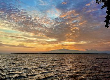
The Cameroon Volcanic Line is a 1,600 km chain of volcanoes extending from the Gulf of Guinea into Cameroon, a natural border between Nigeria and Cameroon. This geologically unusual formation includes both oceanic islands and continental mountains, boasting diverse ecosystems and unique plant and bird life.
- Address
- Equatorial Guinea
Getting there
General
Discover more about Cameroon line
Overview
The Cameroon Volcanic Line (CVL) is a remarkable geological feature, a chain of volcanoes stretching approximately 1,600 kilometers from Annobón Island in the Atlantic Ocean northeastward through Cameroon. This line acts as a natural border between eastern Nigeria and the western region of Cameroon. The CVL is unique because it extends across both oceanic and continental crust.The CVL's volcanic activity began roughly 38 million years ago and continues today. The islands along the CVL boast tropical climates and are home to diverse plant and bird species. The continental portion features volcanic swells such as Manengouba, Bamboutu, and the Oku Massif. The islands of Annobón, São Tomé, Príncipe, and Bioko comprise the oceanic section.The CVL volcanoes have a range of compositions, from picro-basalt and basalt to phonolite and rhyolite. One notable event in the CVL's history is the 1986 Lake Nyos disaster, where a release of carbon dioxide gas from the lake, a crater lake in the Oku volcanic plain, led to over 1,200 fatalities.
Evendo Review Centre
 Google
Guest reviews
Explore Cameroon line on the map
A handpicked selection of must-see spots near Cameroon line, mapped for you.
Get your free copy of our complete guide to Cameroon line, delivered straight to you.
Everything on this page, from opening hours and how to get there to Eve’s tips and the best time to go, in one PDF you can read offline, print or share.
Already have an account? Sign in
Your Cameroon line guide is ready.
We'll send it to · Not you? Sign out

Getting your guide ready…
We are putting together a fresh copy of the Cameroon line guide. This can take up to a minute.
This can take a few moments. If your browser asks, choose Allow so the download can start. You'll find the guide in your Downloads folder.
Nothing happened? Download it again
Sorry, the guide is taking longer than usual. Please try again in a minute, or get it by email instead.
Other nearby places you may find interesting
The closest places of the same kind, if this one is not quite what you had in mind.
-
-
-
-
-


Swipe for more places
More to explore near Cameroon line

 Best experiences near Cameroon line
 Best hotels near Cameroon line
 Best landmarks near Cameroon line
 Best attractions near Cameroon line
 Best shops near Cameroon line
 Best restaurants near Cameroon line
 Best bars near Cameroon line
Do you manage this location?
Take control to get all the benefits, like improved information, better appearance, and stronger visibility across AI-powered discovery.
Explore more
Explore more of South-West Region
Explore the South-West Region of Cameroon: A blend of breathtaking nature, rich culture, and fascinating history awaits you in this captivating destination.
Explore South-West Region
Explore more of Cameroon
Discover Cameroon: A Land of Diverse Landscapes, Rich Cultural Heritage, and Unforgettable Adventures in the Heart of Africa.
Explore Cameroon
