From Eve
Know before you go
Hi, I'm Eve. Here are a few practical things to know before exploring Kampestensbroen ved Ørre.
Local know-how to help you travel smarter and make the most of every moment.

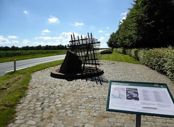
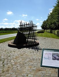
A historic stone bridge marking the transformed course of Sunds Nørreå in Denmark's rural heartland.
Kampestensbroen is a historic stone bridge spanning the old course of Sunds Nørreå river near Ørre in central Denmark. Built over the former riverbed before the waterway was redirected to Nybro Mølle, this modest but significant structure represents the area's agricultural heritage. Located along scenic cycling and walking routes through the Ørre-Nybro landscape, the bridge connects visitors to the region's transformation during the late 19th and early 20th centuries.
Opening times, essentials, and a few local tips gathered into one calmer, easier-to-scan planning section.
Hi, I'm Eve. Here are a few practical things to know before exploring Kampestensbroen ved Ørre.
Local know-how to help you travel smarter and make the most of every moment.
Bicycle from Herning town center
Cycle approximately 20 kilometers southwest from Herning town center via Nybro Møllevej, following the scenic Ørre-area cycling routes. Journey time is approximately 45–60 minutes depending on fitness level and route choice. The route is flat to gently rolling terrain suitable for standard bicycles. Parking for bicycles is available at several points along the Brydningstiden network.
Car from Herning
Drive approximately 20 kilometers southwest from Herning center toward Ørre via Nybro Møllevej. Journey time is approximately 25–30 minutes. Limited roadside parking is available near the bridge location; additional parking exists at the Nybro camping area and nearby community facilities. The road is well-maintained and suitable for standard vehicles.
Walking from Ørre village center
Walk approximately 3–4 kilometers from Ørre village center following the marked Brydningstiden walking routes. Journey time is approximately 45–60 minutes on flat terrain with clear signage. The paths are accessible year-round, though conditions are best from spring through autumn. Sturdy walking shoes are recommended.
Public transport from Herning station
Take a regional bus service from Herning town center toward Ørre or Aulum (journey time approximately 30–40 minutes depending on service). Service frequency is limited; check local timetables in advance. From the bus stop, walk or cycle the final distance to the bridge via local roads and marked routes.
Use Kampestensbroen ved Ørre as your starting point for nearby food, family ideas, nightlife, and more local discoveries.
A quick look at seasonal patterns and peak visiting hours.

Explore expert travel guides, compare and book tours, experiences, hotels, and more—all from the palm of your hand. Download now for seamless trip planning wherever your wanderlust takes you.
Discover Herning, Denmark's cultural epicenter, known for its art, architecture, and natural beauty, offering a unique blend of tradition and modernity.
Tell me more about Herning