Background

Monument på Knudmosebjerget

Herning's highest point with panoramic moorland views and eight scenic walking routes through a protected conservation area.

4.1

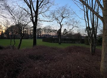
Perched atop Knudmosebjerget hill at 79.3 meters above sea level, this modest monument marks one of Herning's highest points and offers panoramic views across the surrounding landscape. Located within the 230-hectare Knudmosen conservation area, the site serves as a focal point for walkers, runners, and cyclists exploring the region's diverse network of trails through moorland, forest, and open countryside.

A brief summary to P-plads, Knudmosebjerget

  • Herning, 7400, DK
  • Visit website
  • Duration: 0.5 to 2 hours
  • Free
  • Environment icon Outdoor
  • Mobile reception: 4 out of 5

Local tips

  • Visit during clear weather to maximize views from the summit. The purple-marked route offers the best perspective back toward Herning town center.
  • The site is ideal for runners and walkers; allow 30–60 minutes depending on which of the eight routes you choose. The 5.5-kilometer running route takes approximately 33 minutes.
  • Winter visitors can enjoy sledding on the western slopes, but check local conditions first as weather can change rapidly on the exposed hilltop.
  • Bring water and wear appropriate footwear; the moorland terrain can be boggy in wet conditions, and the open hilltop offers little shelter from wind or rain.
  • The site is dog-friendly via the dedicated dog forest area. Cyclists and horse riders can use designated paths throughout Knudmosen.
widget icon

Getting There

  • Car with Parking

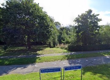
    Drive to the P-plads (parking area) at Knudmosebjerget, located at coordinates 56.125°N, 8.965°E in Herning. The parking area is free and situated directly at the base of the hill. From central Herning, travel approximately 2–3 kilometers south toward MCH Messecenter Herning; the parking area is well-signposted. Driving time from Herning city center is approximately 5–10 minutes depending on traffic. The site is accessible year-round, though winter conditions may affect parking availability during heavy snow.

  • Walking or Running from Herning Center

    Multiple walking and running routes connect Herning's city center to Knudmosebjerget. The most popular purple-marked route begins near Søndre Anlæg and passes through Knudmosen before reaching the hill. Total distance is approximately 5.5 kilometers, taking 33–45 minutes depending on pace. The terrain is mostly level moorland with gentle elevation gain. The route is well-marked with signage and is suitable for all fitness levels, though the open moorland offers no shelter from weather.

  • Bicycle from Herning

    Cycle from Herning city center via the marked cycling routes that connect to Knudmosen. The terrain is flat to gently rolling, making it accessible for casual cyclists. Travel time is approximately 15–25 minutes from central Herning depending on your starting point and route choice. Bike rental is available in the Herning area if you do not have your own bicycle. The cycling paths are well-maintained and suitable for standard road or hybrid bikes.

  • Accessible Route

    An accessible trail designed for people with mobility considerations connects through the Knudmosen area and provides access to viewpoints. This route is clearly marked and maintained to accessibility standards. Parking at the P-plads provides the closest access point. Travel time to reach the main viewpoint via the accessible route is approximately 20–30 minutes at a leisurely pace.

P-plads, Knudmosebjerget location weather suitability

  • Weather icon Clear Skies
  • Weather icon Mild Temperatures
  • Weather icon Any Weather

Unlock the Best of P-plads, Knudmosebjerget

Buy tickets

    No tickets available

Book tours with entry

    No tours available

Book tours without entry

    No tours available

Discover more about P-plads, Knudmosebjerget

A Landmark Above the Moors

The monument at Knudmosebjerget stands as a simple but significant marker of elevation, crowning a hill that rises 79.3 meters above the surrounding terrain—making it one of the highest natural points in the Herning region. The structure itself is modest, yet its location commands attention: from this vantage point, visitors gain sweeping views across the Knudmosen conservation area and the broader West Jutland landscape beyond. The monument serves both as a practical waypoint for outdoor enthusiasts and as a symbolic anchor for the natural area below.

The Knudmosen Conservation Landscape

The monument sits within Knudmosen, a protected natural area spanning approximately 230 hectares. This conservation zone is divided into two distinct character areas, each offering different experiences. The western sector, where Knudmosebjerget is located, has been shaped by human recreation and land use: sledding slopes and skiing areas operate seasonally, while allotment gardens and a poultry colony occupy portions of the terrain. The eastern section presents a more naturalistic character, with extensive networks of cleared paths and open areas that emphasize the bog's ecological diversity. Throughout the reserve, vegetation ranges from open moorland to established forest, creating a mosaic of habitats that shift with the seasons.

Pathways and Recreational Routes

The hill and surrounding Knudmosen area are threaded with eight distinct walking and running routes, each offering different perspectives on the landscape. The purple route, which passes directly through Knudmosebjerget, is particularly popular for its views back toward Herning's town center. A dedicated 5.5-kilometer running route incorporates the hill as a key landmark, taking approximately 33 minutes to complete. Beyond foot traffic, the area accommodates cyclists, equestrians, and visitors with mobility considerations: a bridle path serves horse riders, while an accessible trail ensures that people with disabilities can experience the natural environment. A dog forest within the reserve welcomes canine companions, making the area genuinely inclusive for diverse visitor types.

Seasonal Character and Weather Patterns

Knudmosebjerget's appeal shifts throughout the year. Winter transforms the western slopes into a recreational playground for sledding and skiing, while the exposed hilltop can be windswept and cold. Spring and autumn bring milder conditions ideal for walking and running, with the moorland and forest displaying seasonal color changes. Summer offers the most comfortable temperatures and longest daylight hours, though the site remains accessible year-round. The open moorland and cleared areas provide good visibility in clear weather, though low-visibility conditions can occur during fog or heavy precipitation.

Integration with Herning's Activity Network

The monument and its surrounding area function as part of a larger recreational ecosystem within and around Herning. Located between the city center and MCH Messecenter Herning, Knudmosebjerget serves as a natural anchor point for residents and visitors seeking outdoor activity without traveling far from urban amenities. The site complements other regional attractions and activity centers, making it a practical stop for those exploring Herning's broader outdoor offerings. Its accessibility from the city—reachable by foot, bicycle, or vehicle—ensures it remains one of the area's most frequently visited natural landmarks.

Busiest months of the year

Busiest hours of the day

Popular Experiences near P-plads, Knudmosebjerget

Popular Hotels near P-plads, Knudmosebjerget

Select Currency