From Eve
Know before you go
Hi, I'm Eve. Here are a few practical things to know before exploring Mount Lamlam Trail Head.
Local know-how to help you travel smarter and make the most of every moment.

Hike Guam's Mount Lamlam for panoramic views and a connection to the island's unique natural and cultural history.
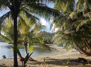
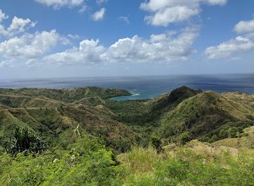
Hike to the summit of Mount Lamlam, Guam's highest point, for panoramic views and a connection to the island's rich history and culture. While modest in height, it's considered the world's tallest mountain when measured from its base in the Mariana Trench.
Opening times, essentials, and a few local tips gathered into one calmer, easier-to-scan planning section.
Hi, I'm Eve. Here are a few practical things to know before exploring Mount Lamlam Trail Head.
Local know-how to help you travel smarter and make the most of every moment.
Driving
From Tumon Bay, drive south on Marine Corps Drive (Route 1). Turn left onto Route 2A, then continue onto Route 2. Drive through Agat and continue for approximately 3 miles. Look for a red wall on the right side of the road where you can park. The trailhead is across the street on the left, marked with a small green sign. If you reach Umatac, you've gone too far. Parking is free.
Public Transport
The Guam Mass Transit Authority (GMTA) operates bus routes connecting most villages on Guam. Take the bus to the nearest stop on Route 1 to the Mount Lamlam Trailhead. From there, it's about a 30-minute walk to the trailhead. A one-way bus ticket is approximately $1.00, and a daily pass is $3.00. Buses operate Monday through Saturday, with limited service on Sundays and holidays.
Taxi/Ride-share
Taxis are readily available at hotels and major shopping centers. A taxi from Tumon Bay to the Mount Lamlam trailhead will cost approximately $40-$50. Ride-sharing services like Uber or Lyft may also be available. The standard flag rate for taxis is $2.40, $4.00 for the first mile, and $0.80 every ¼ mile thereafter.
Use Tower Bridge as your starting point for nearby food, family ideas, nightlife, and more local discoveries.

Explore expert travel guides, compare and book tours, experiences, hotels, and more—all from the palm of your hand. Download now for seamless trip planning wherever your wanderlust takes you.
Discover the serene and culturally rich Mount Jumullong Manglo, offering stunning views and an immersive experience into Guam's natural and cultural heritage.
Tell me more about Mount Jumullong Manglo