From Eve
Know before you go
Hi, I'm Eve. Here are a few practical things to know before exploring Flood levels.
Local know-how to help you travel smarter and make the most of every moment.

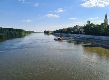
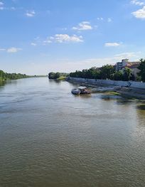
Explore Szeged's Flood Levels – a unique tourist attraction that highlights the city's resilience and rich history along the stunning Tisza River.
Szeged, Hungary, is home to the captivating Flood Levels, a unique tourist attraction that showcases the city's resilience against the natural elements. Visitors can explore the innovative flood markers that tell the story of Szeged's historic battles with the waters, making it a must-see for anyone interested in local culture and history.
Opening times, essentials, and a few local tips gathered into one calmer, easier-to-scan planning section.
Hi, I'm Eve. Here are a few practical things to know before exploring Flood levels.
Local know-how to help you travel smarter and make the most of every moment.
Car
If you're traveling by car from any location in Szeged-Csanád, head towards the city center. Follow the signs leading to Szeged, and navigate towards the coordinates 46.2505317, 20.151961. You can enter these coordinates into your GPS for precise navigation. Once you reach the vicinity, look for local parking options available near the area.
Public Transportation - Tram
For those opting for public transportation, take Tram Line 1 or Line 2 from any main tram stop in Szeged. Make sure to board the tram heading towards the city center. Get off at the 'Kossuth Lajos sugárút' stop. From there, it's a short walk to the flood levels area. Head east on Kossuth Lajos sugárút, then turn left onto Szent István tér. Continue straight until you reach the specified coordinates (46.2505317, 20.151961).
Public Transportation - Bus
Another option is to take a bus. Check the local bus schedules for routes that lead to the Szeged city center. Most buses will stop at the main bus station, which is close to the flood levels area. From the bus station, you can either walk or take a short taxi ride to the coordinates (46.2505317, 20.151961). Make sure to have a valid bus ticket, which can be purchased at kiosks or machines.
Walking
If you are already in the vicinity, walking is a pleasant way to reach the flood levels. Enjoy the local scenery as you make your way. Simply navigate toward the coordinates (46.2505317, 20.151961) by following local streets and signs. It's advisable to use a map or a navigation app on your phone.
Use Flood levels as your starting point for nearby food, family ideas, nightlife, and more local discoveries.

Explore expert travel guides, compare and book tours, experiences, hotels, and more—all from the palm of your hand. Download now for seamless trip planning wherever your wanderlust takes you.
Discover Szeged-Csanád: Hungary's Sunlit Gem with Historic Charm, Vibrant Festivals, and Delicious Cuisine.
Tell me more about Szeged Csanad