From Eve
Know before you go
Hi, I'm Eve. Here are a few practical things to know before exploring Neris Regional Park.
Local know-how to help you travel smarter and make the most of every moment.

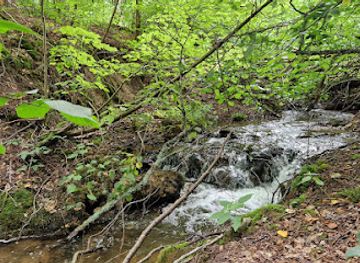
Explore the breathtaking beauty of Neris Regional Park in Lithuania, a perfect destination for outdoor adventures, wildlife watching, and scenic landscapes.
Neris Regional Park is a breathtaking natural escape in Lithuania, offering tourists stunning landscapes, diverse wildlife, and a plethora of outdoor activities. Perfect for nature lovers, this park is a must-visit destination for those looking to explore the great outdoors.
Opening times, essentials, and a few local tips gathered into one calmer, easier-to-scan planning section.
Hi, I'm Eve. Here are a few practical things to know before exploring Neris Regional Park.
Local know-how to help you travel smarter and make the most of every moment.
Car
If you're driving from any location in Suvalkija, head towards the town of Dūkštos. Use a GPS or a navigation app and enter the coordinates: Latitude 54.781769, Longitude 24.954156. Follow the main road signs towards Dūkštos, which is well-connected via the A1 highway. Upon reaching Dūkštos, look for road signs indicating Neris Regional Park. There is parking available near the park entrance.
Public Transportation
To reach Neris Regional Park using public transport, first, find your way to the nearest bus station that operates routes to Dūkštos. Check local schedules as buses may not run frequently. Once on the bus, make sure to get off at the Dūkštos stop. From there, Neris Regional Park is within walking distance. Look for signs pointing towards the park or use a mapping application on your phone to guide you from the bus stop to the park entrance.
Walking
If you arrive in Dūkštos by bus and prefer walking, exit the bus and head towards the park, which is approximately 1.5 km from the bus stop. Follow the main road signs towards the park, or use a navigation app to guide you along the safest walking route. The path is relatively straightforward and offers a scenic view of the surrounding area.
Use Tower Bridge as your starting point for nearby food, family ideas, nightlife, and more local discoveries.

Explore expert travel guides, compare and book tours, experiences, hotels, and more—all from the palm of your hand. Download now for seamless trip planning wherever your wanderlust takes you.
Discover Suvalkija: A blend of Lithuanian heritage, charming landscapes, and rich culinary traditions in the heart of southwestern Lithuania.
Tell me more about Suvalkija