From Eve
Know before you go
Hi, I'm Eve. Here are a few practical things to know before exploring HIGHATLAS View Point.
Local know-how to help you travel smarter and make the most of every moment.

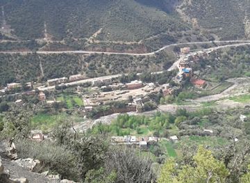
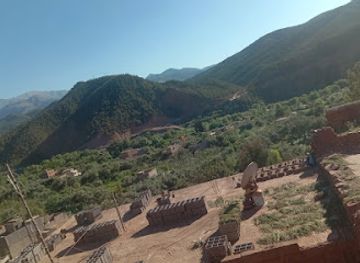
Experience the majestic beauty of the High Atlas Mountains at HIGHATLAS View Point, a breathtaking vantage point for nature lovers and adventure seekers.
Nestled in the stunning landscape of the High Atlas Mountains, HIGHATLAS View Point offers tourists an unforgettable experience with panoramic vistas, breathtaking natural beauty, and a serene atmosphere. It’s a must-visit for nature lovers and adventure seekers alike.
Opening times, essentials, and a few local tips gathered into one calmer, easier-to-scan planning section.
Hi, I'm Eve. Here are a few practical things to know before exploring HIGHATLAS View Point.
Local know-how to help you travel smarter and make the most of every moment.
Car
If you are traveling by car, take the N9 road towards Tamguinguante. From Marrakesh, it is approximately a 2-hour drive. As you approach Tamguinguante, keep an eye out for the coordinates 31.312091, -7.370157 on your GPS. Once you arrive in Tamguinguante, follow local signs towards the HIGHATLAS View Point, which is situated at the coordinates provided. Parking is typically available nearby.
Public Transportation
To reach HIGHATLAS View Point via public transportation, take a bus from Marrakesh to Ouarzazate, which is a common route. Buses depart frequently and the journey takes around 4 hours. Once you arrive in Ouarzazate, you can hire a taxi to take you to Tamguinguante. Make sure to negotiate the fare beforehand, as it may vary. The taxi ride should take about 1 hour. Ensure you provide the driver with the coordinates 31.312091, -7.370157 to reach the View Point directly.
Hiking
For the adventurous, once you reach Tamguinguante by car or public transport, you can hike to the HIGHATLAS View Point. There are marked trails that start from the village. Depending on your fitness level, the hike can take 1-2 hours. It's advisable to wear sturdy hiking boots and bring plenty of water. Check local maps or ask locals for the most popular trails leading to the viewpoint.
Use Tower Bridge as your starting point for nearby food, family ideas, nightlife, and more local discoveries.

Explore expert travel guides, compare and book tours, experiences, hotels, and more—all from the palm of your hand. Download now for seamless trip planning wherever your wanderlust takes you.
Discover the High Atlas in Morocco: A blend of majestic peaks, vibrant Berber culture, and breathtaking landscapes, perfect for adventurers and culture enthusiasts.
Tell me more about High Atlas