Tomasbodahöjden
Conquer Närke's rooftop at 298m on a gentle forest trail in Kilsbergen, where history, geology, and quiet wilderness converge northwest of Örebro.
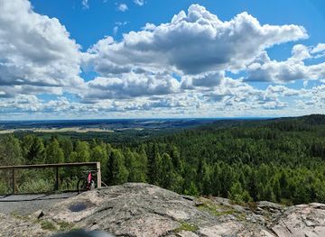
Tomasbodahöjden rises to 298 meters above sea level as the highest point in Närke province and Kilsbergen mountain range, located northwest of Örebro near Garphyttan. This modest summit offers a rewarding short hike along a marked trail through forested terrain, ideal for hikers seeking the thrill of provincial highpointing amid serene Swedish countryside. The well-trodden path features a gentle elevation gain of under 27 meters over a 1.6 km round-trip loop, passing remnants of historical settlements like old farmsteads from the 1600s. Part of the Bergslagsleden trail network, it provides a peaceful spot for picnics with subtle views over rolling hills and distant valleys, evoking the rugged charm of central Sweden's inland landscapes.
A brief summary to Tomasbodahöjden
- Unnamed Road, 705 92, Örebro, SE
- Free
-
Outdoor
- Mobile reception: 3 out of 5
Local tips
- Pack rain gear; sudden showers like hail are common even in summer, adding drama to your summit moment.
- Bring a picnic for the open plateau—perfect for savoring the highpoint solitude amid rustling pines.
- Look for silver round markers on trees; the trail is faint but well-trodden for easy navigation.
- Combine with Bergslagsleden segments for a longer hike, spotting ancient fort ruins nearby.
- Visit in autumn for vibrant foliage and fewer crowds on this provincial pinnacle.
Do you manage this location?
Take control to get all the benefits, like improved information, better appearance, and stronger visibility across AI-powered discovery. Learn more
Activate your presenceOther nearby places you may find interesting
Getting There
-
Car
Drive from Örebro center northwest via Route 204 toward Garphyttan, 25-35 minutes covering 25 km; park at the free trailhead lot near the unmarked road, limited spaces, gravel surface prone to mud after rain.
-
Bus + Walk
Take regional bus 801 from Örebro Resecentrum to Garphyttan (40-50 minutes, 100-150 SEK round-trip); then walk 3-4 km north along quiet roads to trailhead, 45-60 minutes on mixed pavement and gravel, moderate fitness required.
-
Hiking Trail
Arrive via Bergslagsleden from Blankhult trailhead south, 2-3 hours through forests; no fees, but carry water as services sparse, suitable for experienced day-hikers.
-
Taxi
Taxi from Örebro to trailhead parking, 30-40 minutes, 500-700 SEK one-way; reliable but book ahead for return, drivers familiar with highpoint sites.
For the on-the-go comforts that matter to you
-
Seating Areas
-
Picnic Areas
-
Trash Bins
-
Information Boards
Discover more about Tomasbodahöjden
Highest Summit of Närke
Tomasbodahöjden stands at 298 meters above sea level, marking the pinnacle of Närke province and the entire Kilsbergen range. Nestled northwest of Örebro, just north of Garphyttan, this hill exemplifies the understated drama of Sweden's inland topography. Formed by ancient geological fault lines that thrust the Kilsbergen escarpment above the surrounding Närkeslätten plain—an old seabed—the summit offers a tangible connection to millions of years of tectonic history. Hikers reach the top via a clearly marked trail, once equipped with a viewing tower now long removed, leaving a flat, open plateau perfect for reflection.Trails and Terrain
The ascent follows Bergslagsleden, a renowned long-distance path weaving through central Sweden's forests. From the parking area mere steps from the trailhead, the route climbs gently with a total elevation gain below 27 meters. Silver-colored round markers guide the way, though the path is so well-worn that navigation feels intuitive even on misty days. The 1.6 km loop encircles the summit, blending pine-scented woodlands with occasional rocky outcrops, where the air carries whispers of wind through birch leaves and distant bird calls.Historical Echoes of Tomasboda
Below the crest lies Tomasboda, once Kilsbergen's highest village at 279 meters, home to four small farms including Rustorpet from the late 1600s, Wägerstorpet, Kalle-Jansatorpet (also called Kilsbergsstugan), and Scoutstugan. These sites speak to centuries of human adaptation in this rugged borderland, where summer pastures drew farmers from the plains and water-powered mills dotted the slopes. Remnants of iron mining and small-scale charcoal production linger in the soil, tying the hill to Närke's industrial past amid the 57 iron mines of Lekebergslagen.Nature's Quiet Realm
Kilsbergen's forests cloak the summit in a mosaic of conifers and deciduous trees, home to deer, foxes, and birds of prey. The watershed dividing Östersjön and Västerhavet runs along the ridge, underscoring the hill's hydrological significance. Spring brings wildflowers carpeting the trail, while autumn paints the canopy in fiery hues. Though views are partially screened by trees, glimpses reveal the undulating plains, Lake Hjälmaren's distant shimmer, and the faint outline of Örebro's skyline on clear days.Highpointing Haven
For peakbaggers, Tomasbodahöjden holds iconic status as Närke's must-conquer summit, often paired with nearby challenges like Eskilsberget. The site's accessibility belies its allure—reaching the trig point delivers a quiet triumph, celebrated with geocaches and summit logs. Local lore includes tales of sudden hailstorms, as recounted by early 21st-century visitors who braved the weather for that obligatory top photo amid swirling clouds.Seasonal Rhythms
Winter transforms the trail into a snowshoe paradise, with cross-country ski tracks linking to broader networks. Summer invites berry picking and matsäck picnics at the summit, where the plateau invites lingering. The ever-changing light filters through branches, casting patterns that shift with the sun's arc, making each visit a unique communion with this unpretentious giant of Närke.Explore the best of what Tomasbodahöjden has to offer
Your all‑in‑one travel companion app
Explore expert travel guides, compare and book tours, experiences, hotels, and more—all from the palm of your hand. Download now for seamless trip planning wherever your wanderlust takes you.