Mjälleborgen, Östersund Travel Guide
Free Guide: An imposing Roman Iron Age hillfort on Öneberget — earthwork terraces and timber traces that speak of early iron trade and regional power in Jämtland.


A brief summary of Mjälleborgen
An imposing Roman Iron Age hillfort on Öneberget — earthwork terraces and timber traces that speak of early iron trade and regional power in Jämtland.
Mjälleborgen is an ancient hillfort on Öneberget on Frösön, one of Sweden’s northernmost fornborgar; built in the Roman Iron Age (c. 300–400s AD), it survives as a long terraced earth-and-stone rampart and traces of timber structures and longhouses, a testimony to organised regional power tied to iron production and trade in the Storsjöbygden.
On-site amenities
 Information boards
 Seating areas
 Trash bins
Opening hours
- Every dayOpen 24 hours
Opening hours as listed on the venue’s Google Business Profile. Hours can change for services and special events, so check with the venue before you go.
- Address
- Frösövägen, 832 47 Frösön
- Website
Getting there
Local bus and short walk
Taxi
Car then short walk
Discover more about Mjälleborgen
Origins and strategic purpose
Mjälleborgen was constructed during the Roman Iron Age (around the 3rd–5th centuries AD) on the flattish northern slope of Öneberget, Frösön. Archaeological investigation shows a roughly 120-metre-long and c.10-metre-wide terrace of earth and stone that formed the visible core of the enclosure, supplemented where the rock was steep by natural cliffs on the opposite side. The site’s scale and building techniques — including a surviving internal timber construction and evidence for an encircling palisade — mark it as one of northern Sweden’s major prehistoric works.
Economic and regional context
The hillfort sits in a landscape known for early iron production and trade: at its height in the 4th–6th centuries the region saw considerable ironworking and exchange along inland and coastal routes. Mjälleborgen’s elevated position gave those who controlled it oversight of fields, waterways and routes towards Trøndelag and Medelpad, implying the site functioned both as a stronghold and a centre for controlling resources (notably iron) and local administration during a formative period in Jämtland’s development.
Archaeology and physical remains
Excavations have revealed evidence of multiple phases: the fort was burned at least twice between the 300s and 500s, while traces of two longhouses dated to the 6th century indicate domestic or administrative buildings inside the enclosure. The terracing and stonework visible today is the weathered remnant of earthworks supported by timber; earlier descriptions and specialist studies reconstruct a palisaded rampart built up from timber, earth and stone to create a defended platform on the more open side of the hill.
Landscape and setting
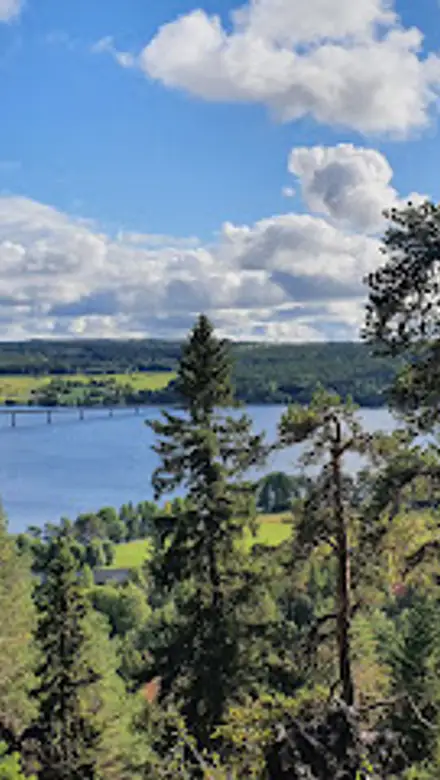
Mjälleborgen occupies a small hilltop overlooking cultivated lowlands that slope down to the Storsjön shoreline. From its elevated terrace you can picture the mixture of arable fields, meadow and woodland that sustained Iron Age communities and their livestock. The fort’s setting contributes to the sense of a place that combined defensibility with control of communication corridors and local farmland, a nod to why the site was repeatedly rebuilt and repaired during centuries of regional change.
Continuity, abandonment and later significance
While the site was abandoned in the early medieval period — archaeological evidence suggests decline around the 7th–8th centuries — its existence is an important marker of social organisation in Jämtland long before later medieval centres emerged. Mjälleborgen must be read alongside other nearby remains and historic sites to understand the island’s long cultural continuity: it sits within a rich cultural landscape whose features extend from prehistoric enclosures to medieval farmsteads and later historic monuments.
Visiting the remains today
Today the earthworks are visible as a low but clear terraced bank on Öneberget; the fort is a cultural monument in the wider context of Frösön’s archaeological environment. The site’s scale is best appreciated by moving slowly around the terrace, imagining the timber palisade and longhouses once standing where today there are only subtle rises and scatter of stone. Quiet observation rewards visitors with a tangible sense of deep-time human activity and regional connections across inland Scandinavia.
Evendo Review Centre
 Google
Guest reviews
Best time to go
Quietest: Jan, Feb & Dec · before 7am
Busy times are Evendo estimates for a typical year, to help you plan. Actual crowds vary with events, school holidays and the weather.
Explore Mjälleborgen on the map
A handpicked selection of must-see spots near Mjälleborgen, mapped for you.
Get your free copy of our complete guide to Mjälleborgen, delivered straight to you.
Everything on this page, from opening hours and how to get there to Eve’s tips and the best time to go, in one PDF you can read offline, print or share.
Already have an account? Sign in
Your Mjälleborgen guide is ready.
We'll send it to · Not you? Sign out

Getting your guide ready…
We are putting together a fresh copy of the Mjälleborgen guide. This can take up to a minute.
This can take a few moments. If your browser asks, choose Allow so the download can start. You'll find the guide in your Downloads folder.
Nothing happened? Download it again
Sorry, the guide is taking longer than usual. Please try again in a minute, or get it by email instead.
Other nearby places you may find interesting
The closest places of the same kind, if this one is not quite what you had in mind.
-
-
-
-
-


Swipe for more places
More to explore near Mjälleborgen

 Best experiences near Mjälleborgen
 Best hotels near Mjälleborgen
 Best landmarks near Mjälleborgen
 Best attractions near Mjälleborgen
 Best shops near Mjälleborgen
 Best restaurants near Mjälleborgen
 Best bars near Mjälleborgen
Do you manage this location?
Take control to get all the benefits, like improved information, better appearance, and stronger visibility across AI-powered discovery.
Explore more
Explore more of Östersund
Discover Östersund, a scenic Swedish city known for its winter sports, vibrant cultural scene, and delicious local cuisine, nestled by the beautiful Lake Storsjön.
Explore Östersund
Explore more of Sweden
Discover Sweden's breathtaking landscapes, vibrant cities, and rich cultural heritage. From the Northern Lights to historic castles, experience the essence of Scandinavia.
Explore Sweden