

Björnöbacken, Västerås Travel Guide
Free Guide: A compact, year‑round outdoor hub on Björnön with a small slalom slope, varied fitness trails and lake viewpoints.


A brief summary of Björnöbacken
A compact, year‑round outdoor hub on Björnön with a small slalom slope, varied fitness trails and lake viewpoints.
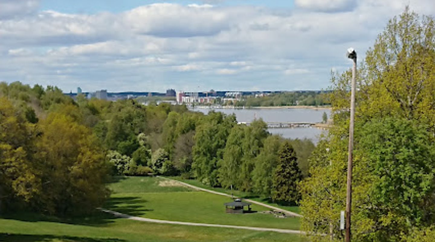
Björnöbacken is the tree‑lined hill and recreational heart of Björnön island in Västerås, offering a compact slalom slope, winding fitness trails, viewpoints over Lake Mälaren and year‑round outdoor facilities centred around Björnögården. Popular with runners, families and mountain bikers, the area combines gentle shoreline beaches, wooded climbs and picnic spots within easy reach of the city.
On-site amenities
 Restrooms
 Drink options
 Food options
 Seating areas
 Information boards
Opening hours
- Every dayOpen 24 hours
Opening hours as listed on the venue’s Google Business Profile. Hours can change for services and special events, so check with the venue before you go.
- Address
- SO, Västerås
Getting there
By local bus
By car
By bike
Discover more about Björnöbacken
A compact slope with surprising verticality
Björnöbacken reads at first like a local hill but its fall and gradient make it a genuine small alpine feature: several short downhill runs and two lifts concentrate winter activity into a steep, easily read slope that locals use for skiing, sledging and fitness challenges year after year. The slope’s modest length is balanced by a crisp, open aspect toward the lake; in winter the run is a clear funnel of movement while in summer the scar becomes a grassy rise used for training and events.
Trails that loop the island’s changing moods
The network of motion trails around Björnö runs across a variety of surfaces: compact forest paths, narrow singletrack and wider service trails that connect parks, beaches and viewpoints. Options range from short lit loops to longer 10 km circuits that trace much of the island’s shore; benches and small rest points are spaced along ridge sections, giving repeated outlooks over Mälaren and the ship traffic below.
Björnögården: activity hub and low‑key base
At the foot of the hill, Björnögården functions as the island’s activity centre and meeting place. Established as a community facility in the mid‑20th century, it now hosts equipment rental, guided outings, a simple café and seasonal programmes including mountain‑bike hire, paddle sports and sauna experiences. The building’s undemanding, practical character reflects its role: a welcoming base between trails and waterfront.
Every season writes a new script
Spring opens the island’s quieter edges—muddy tracks firm and migratory birds return—while summer turns shorelines into swimming coves and picnic nooks. Autumn brings a woody palette across the slopes and is a preferred time for crisp runs on foot; winter compresses activity into snow and ice: prepared skating tracks on the lake, groomed ski trails and the slalom slope itself. The place’s year‑round appeal is its adaptability rather than any single spectacular feature.
Community uses and local traditions
Björnöbacken is threaded into local sporting traditions: club challenges, timed uphill events and the informal “Björnöeverest” challenge—many athletes repeatedly climb the slope as a vertical‑gain test—illustrate how the hill anchors a culture of measured endurance and outdoor training. Family rituals—pulkas, barbecues by the water, evening swims—sit alongside organised programmes from the activity centre.
The landscape: shoreline, forest and lookout points
The island’s geology and vegetation give Björnöbacken a layered character: a ridge of mixed woodland that drops to sheltered bays, stony beaches and small grassy clearings. Viewpoints along the higher trail reveal sweeping water views and a sense of connection with Mälaren’s shifting light. Facilities are intentionally low‑key: paths, simple seating and waymarked circuits that prioritise outdoor access while retaining a natural feel.
Evendo Review Centre
 Google
Guest reviews
Best time to go
Quietest: Mar, Apr & Nov · before 6am or at 10pm
Busy times are Evendo estimates for a typical year, to help you plan. Actual crowds vary with events, school holidays and the weather.
Explore Björnöbacken on the map
A handpicked selection of must-see spots near Björnöbacken, mapped for you.
Get your free copy of our complete guide to Björnöbacken, delivered straight to you.
Everything on this page, from opening hours and how to get there to Eve’s tips and the best time to go, in one PDF you can read offline, print or share.
Already have an account? Sign in
Your Björnöbacken guide is ready.
We'll send it to · Not you? Sign out

Getting your guide ready…
We are putting together a fresh copy of the Björnöbacken guide. This can take up to a minute.
This can take a few moments. If your browser asks, choose Allow so the download can start. You'll find the guide in your Downloads folder.
Nothing happened? Download it again
Sorry, the guide is taking longer than usual. Please try again in a minute, or get it by email instead.
Other nearby places you may find interesting
The closest places of the same kind, if this one is not quite what you had in mind.
-
-
-
-
-


Swipe for more places
More to explore near Björnöbacken

 Best experiences near Björnöbacken
 Best hotels near Björnöbacken
 Best landmarks near Björnöbacken
 Best attractions near Björnöbacken
 Best shops near Björnöbacken
 Best restaurants near Björnöbacken
 Best bars near Björnöbacken
Do you manage this location?
Take control to get all the benefits, like improved information, better appearance, and stronger visibility across AI-powered discovery.
Explore more

Explore more of Västerås
Discover Västerås, a captivating blend of history, nature, and modernity by the scenic Lake Mälaren, offering a rich tapestry of experiences for every traveler.
Explore Västerås
Explore more of Sweden
Discover Sweden's breathtaking landscapes, vibrant cities, and rich cultural heritage. From the Northern Lights to historic castles, experience the essence of Scandinavia.
Explore Sweden
