From Eve
Know before you go
Hi, I'm Eve. Here are a few practical things to know before exploring Mount Kaputjugh.
Local know-how to help you travel smarter and make the most of every moment.

Discover Mount Kaputjugh: Armenia's stunning border peak offering panoramic views, challenging hikes, and rich biodiversity.
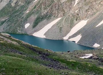
Mount Kaputjugh, straddling the border between Armenia and Azerbaijan, is the highest peak in the Zangezur range and the second highest point in Armenia. Rising to 3,905 meters (12,812 ft), it offers stunning panoramic views and challenging hiking opportunities for adventure enthusiasts.
Opening times, essentials, and a few local tips gathered into one calmer, easier-to-scan planning section.
Hi, I'm Eve. Here are a few practical things to know before exploring Mount Kaputjugh.
Local know-how to help you travel smarter and make the most of every moment.
Car
To reach Mount Kaputjugh by car, head south from Goris on the M2 highway. Drive approximately 30 kilometers until you reach the village of Meghri. From Meghri, follow the road towards the mountains, keeping an eye out for signs for Mount Kaputjugh. Be aware that the final kilometers may involve driving on unpaved roads, so ensure your vehicle is suitable for this terrain. Parking is available at the base of the mountain. There are roads to get near the summit in Azerbaijan. On the northern side, a road ends at 3,518m above sea level. Starting from Nəsirvaz, the road is about 15km long. On the southern side, a road ends at 3,517m above sea level. Starting from Parağaçay, the road is about 15km long.
Public Transport
To get to Mount Kaputjugh using public transportation, take a bus from Goris to Meghri. Buses regularly depart from the Goris bus station; a one-way ticket typically costs around 500 AMD. Upon arrival in Meghri, you may need to hire a taxi or find a local minibus heading towards the mountain area. A taxi from Meghri to the base of Mount Kaputjugh may cost between 2000 and 5000 AMD, depending on negotiation and the exact drop-off point.
Use Tower Bridge as your starting point for nearby food, family ideas, nightlife, and more local discoveries.

Explore expert travel guides, compare and book tours, experiences, hotels, and more—all from the palm of your hand. Download now for seamless trip planning wherever your wanderlust takes you.
Discover Syunik, Armenia's southern treasure trove of natural beauty, ancient monasteries, and charming villages. Perfect for adventurers and history enthusiasts alike.
Tell me more about Syunik