Backbone Trail
Backbone Trail: A Journey Through the Santa Monica Mountains

Hike the Backbone Trail: A scenic 67-mile journey through the heart of the Santa Monica Mountains, offering stunning views and diverse landscapes.
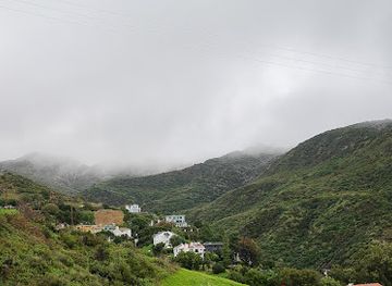
The Backbone Trail is a 67.79-mile (109.10 km) National Recreation Trail that traverses the Santa Monica Mountains, offering diverse landscapes from coastal vistas to inland canyons. It stretches from Will Rogers State Historic Park to Point Mugu State Park, providing a challenging yet rewarding hiking experience through a unique Mediterranean ecosystem.
Opening times, essentials, and a few local tips gathered into one calmer, easier-to-scan planning section.
Driving & Shuttle
To access the Backbone Trail from Los Angeles, driving is the most practical option. Depending on the trailhead you choose, navigate to the Pacific Coast Highway (Highway 1) for western access points like Point Mugu State Park, or take the 101 Freeway to reach trailheads closer to the city, such as those near Topanga State Park or Will Rogers State Historic Park. Parking fees vary depending on the park. For example, Will Rogers State Historic Park charges for day-use parking. If planning a point-to-point hike, consider using a ride-sharing service or arranging a car shuttle between trailheads. Keep in mind that overnight parking can be difficult to arrange at some trailheads.
Public Transport
While public transportation directly to Backbone Trail trailheads is limited, you can combine bus routes with ride-sharing services. For trailheads near the coast, take the Metro Bus Line 534 to reach areas along the Pacific Coast Highway, then use a ride-sharing app to get to the specific trailhead. For trailheads further inland, take a Metro Bus to a central location like a park-and-ride near the 101 Freeway, then use a ride-sharing service to complete your journey to the trailhead. Cost: Metro bus fares are typically around $1.75 per ride, with day passes available for approximately $3.50. Ride-sharing costs will vary depending on distance and demand.
Use Tower Bridge as your starting point for nearby food, family ideas, nightlife, and more local discoveries.

Explore expert travel guides, compare and book tours, experiences, hotels, and more—all from the palm of your hand. Download now for seamless trip planning wherever your wanderlust takes you.

Discover Oxnard, California: A serene coastal city known for its stunning beaches, rich history, and vibrant cultural events, offering an idyllic escape in Southern California.
Tell me more about Oxnard