Ravnsby Bakker
Rolling hills and ancient monuments where glacial history meets contemporary art on Denmark's flattest island.
A Glacial Landscape Unlike Any Other on Lolland
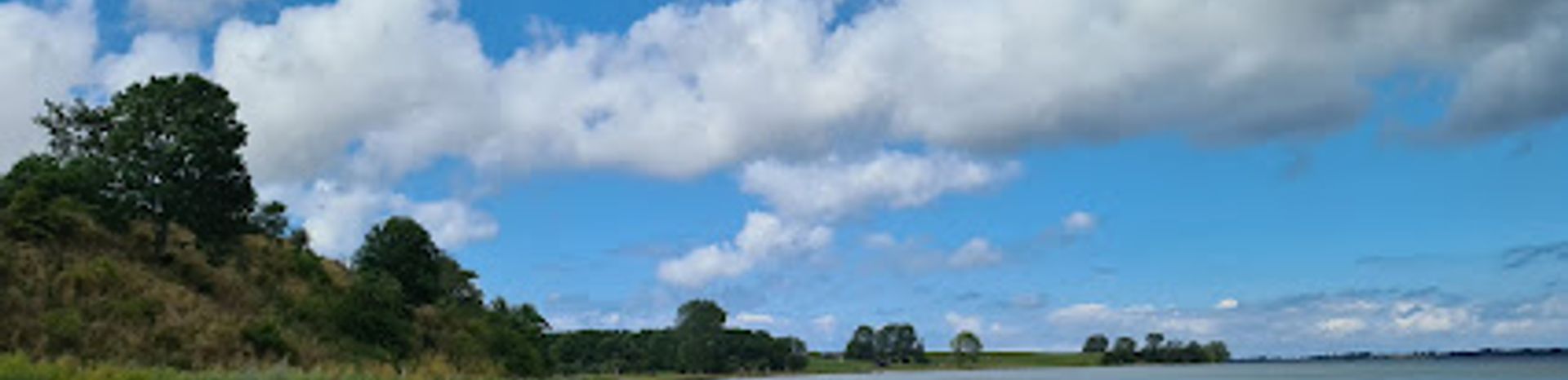
Ravnsby Bakker occupies a unique position on Denmark's map as the only significantly undulating terrain on an otherwise famously flat island. Located on Lolland's northwestern coast facing Smålandsfarvandet, this rolling landscape was sculpted approximately 20,000 years ago during the last ice age, when massive ice sheets advanced and retreated across the region. The resulting topography—marked by pronounced hills, deep valleys, and tunnel valleys—stands in stark contrast to the engineered flatness of southern Lolland, which was artificially drained and diked following the catastrophic storm surge of 1872. Locals affectionately refer to Ravnsby Bakker as "the Lolland Alps," a tongue-in-cheek acknowledgment of both its relative elevation and its exceptional rarity on an island known for its pancake-flat horizons.Ancient Settlements and Archaeological Richness
The Ravnsby Bakker region carries profound historical significance stretching back millennia. Archaeological evidence reveals that the area was inhabited during the Ertebølle culture, a Mesolithic period marked by sophisticated coastal settlement patterns. Most notably, the coastal stretch from Ravnsholt to Ravnsby preserves more than 70 Bronze Age burial mounds, several of which contain megalithic chamber tombs known as jættestuer. These monuments testify to the region's importance as a center of prehistoric settlement and ritual practice, offering tangible connections to Denmark's distant past and the cultures that flourished along these ancient shorelines.Dodekalitten: Contemporary Art in a Historic Landscape
In 2013, following the successful completion of a preservation case, the land was acquired to establish Dodekalitten, an extraordinary contemporary art installation conceived as a 12-year creative project. The work consists of twelve granite columns arranged in a circle on a meadow within Ravnsby Bakker, with the final stones to be completed over the coming years. The installation is accompanied by Solkreds, a permanent, computer-controlled electroacoustic music composition that plays during daylight hours, creating an immersive sensory experience that merges art, landscape, and sound. The work draws conceptual inspiration from the region's rich archaeological heritage and its Bronze Age monuments, creating a dialogue between ancient and contemporary expressions of human creativity.Natural Beauty and Recreational Opportunity
Beyond its cultural and historical dimensions, Ravnsby Bakker offers visitors genuine outdoor recreation and natural beauty. The undulating terrain provides genuine elevation changes—a rarity on Lolland—allowing visitors to ascend to viewpoints that offer panoramic vistas across the landscape and toward the islands of Smålandshavet. The area's combination of hills, valleys, and idyllic lakes creates diverse habitats and scenic compositions that reward exploration on foot or by bicycle. The landscape's complexity and visual variety make it an ideal destination for nature walks, photography, and cycling excursions, particularly for those seeking to experience Lolland beyond its characteristically flat agricultural plains.Local tips
- Visit during daylight hours to experience Solkreds, the electroacoustic music installation at Dodekalitten, which plays only in daylight and creates an immersive soundscape across the granite columns.
- Explore the numerous Bronze Age burial mounds scattered throughout the coastal region between Ravnsholt and Ravnsby; several contain preserved megalithic chamber tombs offering tangible connections to prehistoric settlement.
- Ascend to the higher points within the rolling terrain to gain panoramic views across Smålandsfarvandet toward Fejø, Femø, and other islands—a perspective impossible elsewhere on flat Lolland.
- Combine a visit with cycling along the N8 Baltic Sea Route, which passes through the region and connects idyllic villages and coastal harbors with varying terrain.
- Allow time to simply observe the landscape's geological complexity; the deep valleys and pronounced hills reveal the dramatic forces that shaped this terrain during the last ice age.
A brief summary to Ravnsby Bakker
- Fyrværkervej, Torrig, Torrig L, 4943, DK
Getting There
-
Car from Nakskov
From Nakskov town center, drive northwest toward Kragenæs and Torrig via Route 287 and local roads. The journey takes approximately 20–25 minutes covering roughly 20 kilometers. Parking is available at or near the Dodekalitten site and surrounding areas. No entrance fee is required; the landscape and art installation are freely accessible.
-
Bicycle from Nysted
From Nysted, follow the N8 Baltic Sea cycling route northward toward Ravnsby Bakker. The route passes through varied coastal terrain and connects idyllic villages; the journey takes approximately 45–60 minutes depending on pace and route variations. The terrain becomes noticeably hillier as you approach Ravnsby Bakker, offering genuine elevation changes rare on Lolland. No fee required.
-
Walking from Torrig village
From Torrig village center, walking paths lead into Ravnsby Bakker's rolling terrain. The walk takes 15–30 minutes depending on your destination within the landscape. Terrain is moderately hilly with some steep sections; comfortable footwear is recommended. The landscape is open and accessible year-round, though winter conditions may affect path conditions.
-
Bus from Nakskov
Local bus services connect Nakskov to villages within or near Ravnsby Bakker, though service frequency is limited and journey times vary. Check current schedules with local transport providers. Journey time typically ranges from 25–40 minutes. Fares are modest; verify current pricing with the transport operator.


