

Danakil Depression Travel Guide - Free Web & App
Your ultimate guide to Danakil Depression. Discover top landmarks, proposed trips, and local tips. Free on the web or via the Evendo companion app.


Explore Ethiopia’s Danakil Depression for Dallol’s salt formations, Erta Ale volcano, Afar culture and one of Earth’s most extreme landscapes.
A Landscape Below Sea Level
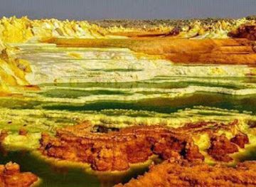
In Ethiopia’s remote Afar Region, the Danakil Depression is a fiercely dry basin of salt flats, sulphur-stained hydrothermal fields, volcanic cones and deeply fractured ground. Much of the Ethiopian Danakil lies below sea level, where intense heat, scarce water and mineral-rich springs create a landscape that appears almost unreal but is the product of active geological forces. The region forms part of the Afar Triangle, where three tectonic plates are gradually pulling apart, and its scenery changes from white salt plains to vivid yellow and green deposits around Dallol and dark basaltic terrain near Erta Ale.Read more about Danakil Depression
Afar Heritage and Expedition Travel
Volcanoes, Salt and Extreme Conditions
When is the best time to visit Danakil Depression?
Best: January, August–September · 35°C| Month | High (°C) | Rainfall (mm) |
|---|---|---|
| January (best) | 35 | 0 |
| February | 36 | 0 |
| March | 36 | 0 |
| April | 37 | 0 |
| May | 36 | 0 |
| June | 36 | 0 |
| July | 35 | 0 |
| August (best) | 35 | 0 |
| September (best) | 35 | 0 |
| October | 35 | 0 |
| November | 36 | 0 |
| December | 36 | 0 |
Best attractions in Danakil Depression
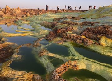
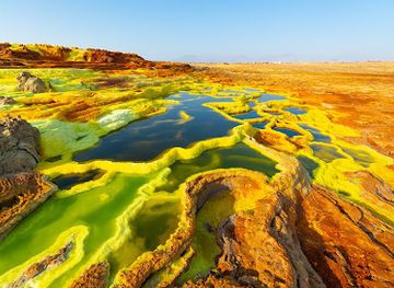
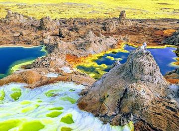
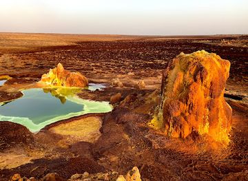
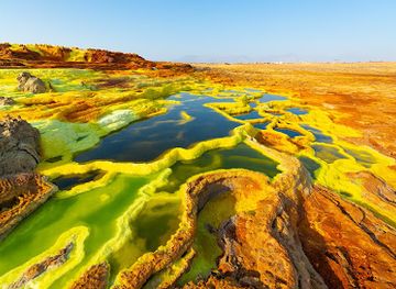
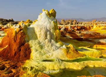
The Danakil’s principal attractions are geological landscapes rather than conventional visitor facilities. Dallol is known for vividly coloured hydrothermal deposits, salt crusts, acidic pools and fumarolic ground, although these features are hazardous and must be viewed with a guide. The broad salt flats around Lake Karum, also called Lake Assal in some travel accounts, are associated with salt cutting and camel caravans, creating a powerful connection between landscape and local livelihoods. Erta Ale, one of Ethiopia’s active shield volcanoes, is reached by a demanding desert expedition and may display changing volcanic activity; a lava lake should never be assumed to be present or safely observable. Lake Afrera, in the wider Afar lowlands, offers another saline landscape where access conditions vary. Hamed Ela functions mainly as a staging settlement rather than a conventional attraction, while Afar villages and caravan routes provide cultural context when approached respectfully.
-
Volcano
Dallol
Discover the mesmerizing beauty of Dallol, Ethiopia's volcanic wonderland filled with vibrant colors and unique geological formations.
-
Tourist attraction
Dallol Depression ዳሎል መታሕት
Explore the Dallol Depression, Ethiopia's vibrant geothermal wonderland, featuring colorful landscapes and unique geological marvels.
-
National park
Danakil volcano
Discover the vibrant landscapes and geothermal marvels of Danakil Volcano, a stunning national park in Ethiopia's Danakil Depression.
-
Lake
Lake Karum
Discover the stunning beauty of Lake Karum in Ethiopia, a mesmerizing salt lake offering breathtaking landscapes and unique photographic opportunities.
Best landmarks in Danakil Depression
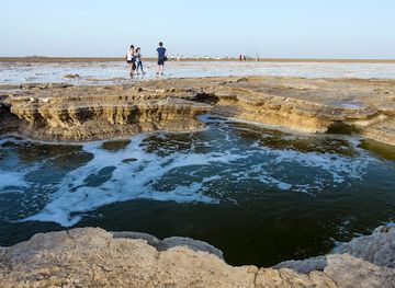
Dallol is the Danakil’s most recognisable natural landmark, a low-lying hydrothermal field where sulphur and other minerals create intense yellow, orange, green and white surfaces around pools and vents. The salt flats of Lake Karum form another defining feature, their geometric crusts and worked salt blocks revealing the basin’s powerful evaporation and long association with caravan trade. Erta Ale is a major volcanic landmark on the depression’s basaltic terrain, although its visible activity, access route and exclusion zones can change. Across the basin, rift faults, black lava fields, salt polygons and isolated volcanic cones express the continuing separation of tectonic plates. Hamed Ela is significant primarily as a logistical and cultural staging point, while Afar camel caravans and salt-working areas are living heritage rather than monuments to be treated as scenery.
-
Volcano
Dallol
Discover the otherworldly landscapes of Dallol, Ethiopia's stunning geothermal wonderland filled with vibrant colors and unique geological phenomena.
-
Tourist attraction
Dallol Depression ዳሎል መታሕት
Discover the surreal beauty of Dallol Depression, a vibrant geothermal wonderland in Ethiopia, where nature's colors and shapes inspire awe.
-
Tour agency
danakil depression
Discover the surreal landscapes of the Danakil Depression, where nature's extremes create a breathtaking adventure in Ethiopia's heart.
Explore Danakil Depression on the map
Plan your trip on one map. See where the top attractions, landmarks, restaurants and hotels are, and book hotels and experiences in a few clicks.
Best hotels in Danakil Depression
Best shops in Danakil Depression
Shopping opportunities inside the Danakil are extremely limited and should not be confused with a conventional retail experience. The region’s characteristic product is salt, traditionally cut into blocks and transported by camel caravans towards markets in the Ethiopian highlands, but visitors should not handle or purchase work materials without permission. Small incidental purchases may be possible through expedition arrangements or in settlements along the route, though availability cannot be assumed. More practical shopping, including food, water, batteries, clothing and travel supplies, is concentrated in gateway towns such as Mekele and Semera before departure. In those towns, visitors may encounter Ethiopian textiles, woven goods, coffee, spices and locally made crafts, but products and retail choices vary. Buying directly from local artisans or communities should be done respectfully and without disrupting work or customary exchange.
-
Tour operator
Great Ethiopian Tours
Discover the breathtaking landscapes and rich culture of Ethiopia with Great Ethiopian Tours, your gateway to unforgettable adventures.
-
Travel agency
Rock Ethiopia Tours
Discover the breathtaking beauty and rich culture of Tigray with Rock Ethiopia Tours, your expert guide to unforgettable adventures in Mekelle.
Get your free copy of our complete guide to Danakil Depression, delivered straight to you.
Everything on this page, from attractions and restaurants to essentials and local phrases, in one PDF you can read offline, print or share.
Already have an account? Sign in
Your Danakil Depression guide is ready.
We'll send it to · Not you? Sign out

Getting your guide ready…
We are putting together a fresh copy of the Danakil Depression guide. This can take up to a minute.
This can take a few moments. If your browser asks, choose Allow so the download can start. You'll find the guide in your Downloads folder.
Nothing happened? Download it again
Sorry, the guide is taking longer than usual. Please try again in a minute, or get it by email instead.
Danakil Depression essentials
Local Tips
From Eve
Local phrases worth knowing
You don't need to get them perfect. A few words go a long way, and locals appreciate the effort.
Basics
| English | Local | Say it |
|---|---|---|
| Hello | ሰላም | [selam] |
| Goodbye | ወደላይ | [waddalay] |
| Yes | አዎ | [aw] |
| No | አይ | [ay] |
| Please/You're welcome | እባኮት | [ebakot] |
| Thank you | አመሰገኛለሁ | [amesegagnalehu] |
| Excuse me/Sorry | በዚህ ጊዜ ስለሁ | [bezih gize selega] |
| How are you? | እንዴት ነህ? | [indet neh?] |
| Fine. And you? | በጣምህነህ. እኔስ? | [betamheneh. enes?] |
| Do you speak English? | እንዴት እንዴት እንዴት እንዴት እንዴት? | [indet indet indet indet indet?] |
| I don't understand | አይቻልኝ | [aychaleng] |
Eating & Drinking
| English | Local | Say it |
|---|---|---|
| I'd like to see the menu, please | ማኔ አይችልም | [mane aychilm] |
| I don't eat meat | አታውራት አይችልም | [atarwat aychilm] |
| Cheers! | ሰማይ! | [semay] |
| I would like to pay, please | መንገድ አይችልም | [mangid aychilm] |
Emergencies
| English | Local | Say it |
|---|---|---|
| Help! | እዬ! | [eye] |
| Go away! | ይሄ! | [yihe] |
| Call the Police! | ሰበር ለአዲስ ፖሊስ! | [seber leadis polis] |
| Call a doctor! | ሰበር ለየጡ! | [seber layetu] |
| I'm lost | ወደላይ | [waddalay] |
| I'm ill | እየአለም | [eyealem] |
Shopping
| English | Local | Say it |
|---|---|---|
| I'd like to buy... | ማኔ አይችልም... | [mane aychilm...] |
| I'm just looking | እንሱ ለማገል አይችልም | [ensu lemagel aychilm] |
| How much is it? | በዚህ ጊዜ እባኮት | [bezih gize ebakot] |
| That's too expensive | እንዴት እንዴት እንዴት እንዴት እንዴት እንዴት | [indet indet indet indet indet indet] |
| Can you lower the price? | በዚህ ጊዜ እባኮት | [bezih gize ebakot] |
Time & Numbers
| English | Local | Say it |
|---|---|---|
| What time is it? | ሰዓት ማን ነው? | [sa'at man new?] |
| It's one o'clock | አንድ ሰዓት ነው | [and sa'at new] |
| Half past (10) | አምስን ሰዓት | [amsin sa'at] |
| Morning | ከሆንህ | [kehonh] |
| Afternoon | ከወጋህ | [kegwah] |
| Evening | ከማርያም | [kemariam] |
| Yesterday | ትላንዳል | [telandal] |
| Today | ዛሬ | [zar] |
| Tomorrow | ነገ | [nage] |
| 1 | አንድ | [and] |
| 2 | ሁለት | [hulet] |
| 3 | ሶስት | [sost] |
| 4 | አራት | [arat] |
| 5 | አምስት | [amsit] |
| 6 | ስድስት | [sedist] |
| 7 | ሰባት | [sebat] |
| 8 | ስምንት | [simint] |
| 9 | ዘጠኝ | [zeten] |
| 10 | አስር | [aser] |
Transport & Directions
| English | Local | Say it |
|---|---|---|
| Where's a/the...? | በዚህ አይንቺ...? | [bezih aynchi...?] |
| What's the address? | አድስ ንግግር ነህ? | [adis negger neh?] |
| Can you show me (on the map)? | በዚህ ጊዜ አይንቺ ገብርኤል? | [bezih gize aynchi gebireel?] |
| When's the next (bus)? | በላይ ምን ነው? | [balay min new?] |
| A ticket (to ....) | ትኬት (... ለም) | [tiket (... leme)] |
History of Danakil Depression
Afar Rift and Geological Formation
The Danakil Depression belongs to the Afar Triangle, a major tectonic junction where the Nubian, Somali and Arabian plates are moving apart. Over geological time, this rifting has produced faulting, volcanic activity and a basin that has repeatedly received and lost water. Extreme evaporation has left extensive salt deposits, while continuing crustal movement feeds the volcanoes and hydrothermal systems that define the modern landscape. The depression is therefore not a single volcanic site but part of a developing rift zone whose landforms continue to change.
Afar Communities and Desert Movement
The wider depression has long been inhabited and traversed by Afar pastoral communities, whose knowledge of wells, seasonal routes and harsh desert conditions has been essential to life in the region. Livestock rearing, movement between water sources and exchange across the lowlands formed the practical basis of settlement. Rather than being an empty wilderness, the Danakil is a cultural landscape shaped by routes, customary territories and relationships with neighbouring communities, although permanent settlements are sparse in its most arid areas.
Salt Extraction and Camel Caravans
Salt has been extracted from the basin for generations, creating one of the Danakil’s most recognisable links between geology and human economy. Workers cut blocks from the salt flats, load them onto camels and move them towards markets and settlements in the Ethiopian highlands. The arduous caravan routes helped connect the lowlands with more densely populated regions, and the sight of camel trains crossing the white salt plain remains a defining feature of the area’s cultural heritage. Modern transport has altered the trade without removing its symbolic and economic importance.
European Exploration and Scientific Attention
The Danakil’s remoteness, unusual geology and severe climate attracted explorers, geologists and natural scientists during the nineteenth and twentieth centuries. Their journeys helped bring accounts of the depression’s volcanic features, salt workings and Afar geography to wider attention, although outside descriptions often underestimated the knowledge and agency of local communities. Scientific interest intensified as researchers studied the region as an example of continental rifting, extreme environments and hydrothermal chemistry.
Modern Expeditions and Conservation Concerns
Late twentieth- and early twenty-first-century travel established the Danakil as a specialised expedition destination, particularly through visits to Dallol and Erta Ale. Tourism remains limited by distance, heat, fragile infrastructure and security conditions, and access arrangements can change. The area’s scientific and environmental importance has also encouraged greater caution around volcanic hazards, mineral-rich pools and fragile salt formations. Responsible visitation depends on local guidance, respect for Afar communities and careful attention to current official advice.
Danakil Depression in Photos
Browse through our photo collection highlighting the charm and character of the destination.
Cities in Danakil Depression
The towns and cities of Danakil Depression, and the easiest places to base yourself.

Swipe for more cities
Neighbouring destination travel guides
The closest destinations to Danakil Depression, if you have time for more than one.
-

-

-

-

-


Swipe for more destinations
Explore more

Explore more of Tigray Region
Explore Tigray in northern Ethiopia for Aksumite monuments, cliff-hewn churches, highland landscapes, ancient faith and deeply layered history.
Explore Tigray Region
Explore more of Ethiopia
Discover Ethiopia: A land of ancient history, breathtaking landscapes, and rich cultural heritage, offering an unforgettable journey through time and nature.
Explore Ethiopia