From Eve
Know before you go
Hi, I'm Eve. Here are a few practical things to know before exploring Villingadalsfjall.
Local know-how to help you travel smarter and make the most of every moment.

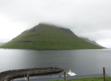
Conquer the heights of Viðoy Island: Hike Villingadalsfjall for breathtaking panoramic views of the northern Faroe Islands.
Hike to the top of Villingadalsfjall, the Faroe Islands' third highest peak, for panoramic views of the northern isles. The challenging but rewarding trek begins in the village of Viðareiði on Viðoy island, offering stunning vistas throughout the ascent.
Opening times, essentials, and a few local tips gathered into one calmer, easier-to-scan planning section.
Hi, I'm Eve. Here are a few practical things to know before exploring Villingadalsfjall.
Local know-how to help you travel smarter and make the most of every moment.
Driving
From Tórshavn, drive north towards Klaksvík on Borðoy island via the Eysturoyartunnilin. Continue north from Klaksvík on Borðoy, crossing the causeway to Viðoy island. Follow the road to Viðareiði. The drive from Tórshavn to Viðareiði is approximately 1 hour. The sub-sea tunnel toll is 100 DKK return.
Public Transport
From Tórshavn, take bus 400 to Klaksvík. From Klaksvík, take bus 500 or 504 to Hvannasund, then transfer to bus 506 to Viðareiði. The total journey time is approximately 3 hours. A single fare from Tórshavn to Klaksvík is approximately 120 DKK. The fare from Klaksvík to Viðareiði is approximately 40-60 DKK.
Walking
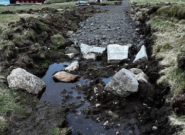
The Villingadalsfjall hike starts in Vidareidi village. The trailhead is located at the end of Garðsvegur road in Við Garð, the northern part of the village. There’s no car park directly at the trailhead. The closest parking area (8-9 cars max) is located just down the road from the trailhead. If this car park is full, park in the village near the church. From the parking area, walk to the end of the road where you'll see an outfield. Follow the path until you reach a gate. The hike begins once you start to see the blue plastic tubes sticking out of the ground.
Use Tower Bridge as your starting point for nearby food, family ideas, nightlife, and more local discoveries.

Explore expert travel guides, compare and book tours, experiences, hotels, and more—all from the palm of your hand. Download now for seamless trip planning wherever your wanderlust takes you.
Discover Norðoyar in the Faroe Islands, where rugged landscapes, rich culture, and serene isolation combine to offer an unforgettable northern adventure.
Tell me more about Norooyar