

Slaughter Bay Travel Guide - Free Web & App
Your ultimate guide to Slaughter Bay. Discover top landmarks, proposed trips, and local tips. Free on the web or via the Evendo companion app.


Slaughter Bay on Norfolk Island offers coastal walks, Kingston’s convict heritage, Emily Bay lagoon and clear waters for swimming and snorkelling.
Coastline and Setting
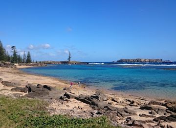
Slaughter Bay lies on the southern coast of Norfolk Island beside Kingston, the island’s principal historic district. Its small shoreline forms part of a sequence of bays and beaches that includes Emily Bay and Cemetery Bay, where coastal scenery, sheltered water and the remains of colonial settlement meet within a compact area. Norfolk Island’s volcanic origins are visible in the dark, rugged outcrops and rolling terrain around the coast, while the open South Pacific gives the bay a spacious, weather-shaped character.Read more about Slaughter Bay
History at the Water’s Edge
Exploring the Area
When is the best time to visit Slaughter Bay?
Best: October–December · 23–25°C| Month | High (°C) | Rainfall (mm) |
|---|---|---|
| January | 27 | 107 |
| February | 27 | 115 |
| March | 27 | 118 |
| April | 26 | 102 |
| May | 24 | 91 |
| June | 22 | 79 |
| July | 21 | 75 |
| August | 21 | 71 |
| September | 22 | 71 |
| October (best) | 23 | 78 |
| November (best) | 25 | 87 |
| December (best) | 25 | 100 |
Getting to and around Slaughter Bay
How to get there
Transportation
Best attractions in Slaughter Bay

Best landmarks in Slaughter Bay
The principal landmark associated with Slaughter Bay is the southern coastal setting itself, framed by Emily Bay, Cemetery Bay and the historic valley of Kingston. Emily Bay’s sheltered beach and shallow lagoon-like waters contrast with the more open character of the neighbouring shore. Inland, the Kingston and Arthur’s Vale Historic Area contains convict-era stone buildings, ruins, roads, cemeteries and Government House, collectively illustrating the organisation of two British penal settlements. Kingston Pier is an important maritime feature, linking the historic settlement with the island’s difficult sea access. The nearby Norfolk Island pine, a defining natural symbol of the island, appears throughout the surrounding landscape, while volcanic slopes and coastal rock provide the geological setting. These features are significant together: the bays explain the settlement’s location, the ruins record its penal history, and the surviving landscape connects colonial structures with the ocean and valley that shaped daily life.

Explore Slaughter Bay on the map
Plan your trip on one map. See where the top attractions, landmarks, restaurants and hotels are, and book hotels and experiences in a few clicks.
Best hotels in Slaughter Bay
Best nightclubs in Slaughter Bay
Slaughter Bay has no independent nightlife district or established cluster of nightclubs. Evenings around the southern coast are generally quiet, with visitors returning to accommodation, dining at a local restaurant or spending time at a pub or hotel venue in Kingston or Burnt Pine. Traditional island hospitality, conversation and occasional live or community entertainment are more characteristic than late-night clubbing, while organised cultural events may vary with the visitor season. Burnt Pine offers the widest choice of places to meet in the evening, although Norfolk Island’s dispersed settlement pattern means that transport should be arranged in advance rather than assuming a convenient taxi after closing time. The quiet shoreline and dark sky around Slaughter Bay are themselves part of the evening atmosphere, provided visitors respect residents, wildlife and heritage sites.
Get your free copy of our complete guide to Slaughter Bay, delivered straight to you.
Everything on this page, from attractions and restaurants to essentials and local phrases, in one PDF you can read offline, print or share.
Already have an account? Sign in
Your Slaughter Bay guide is ready.
We'll send it to · Not you? Sign out

Getting your guide ready…
We are putting together a fresh copy of the Slaughter Bay guide. This can take up to a minute.
This can take a few moments. If your browser asks, choose Allow so the download can start. You'll find the guide in your Downloads folder.
Nothing happened? Download it again
Sorry, the guide is taking longer than usual. Please try again in a minute, or get it by email instead.
Slaughter Bay essentials
Currency and Payment
Safety
Emergency Situations
Do's and Don'ts
Local Tips
From Eve
Local phrases worth knowing
You don't need to get them perfect. A few words go a long way, and locals appreciate the effort.
Basics
| English | Local | Say it |
|---|---|---|
| Hello | G'day | [G'day] |
| Goodbye | See ya | [See ya] |
| Yes | Yeah | [Yeah] |
| No | Nah | [Nah] |
| Please/You're welcome | Please/No worries | [Please/No worries] |
| Thank you | Ta | [Ta] |
| Excuse me/Sorry | Sorry | [Sorry] |
| How are you? | How you goin'? | [How you goin'?] |
| Fine. And you? | Good. You? | [Good. You?] |
| Do you speak English? | You speak English? | [You speak English?] |
| I don't understand | I don't get ya | [I don't get ya] |
Eating & Drinking
| English | Local | Say it |
|---|---|---|
| I'd like to see the menu, please | I wanna have a look at the menu, thanks | [I wanna have a look at the menu, thanks] |
| I don't eat meat | I don't eat meat | [I don't eat meat] |
| Cheers! | Cheers! | [Cheers!] |
| I would like to pay, please | I wanna pay now, thanks | [I wanna pay now, thanks] |
Emergencies
| English | Local | Say it |
|---|---|---|
| Help! | Help! | [Help!] |
| Go away! | Piss off! | [Piss off!] |
| Call the Police! | Get the coppers! | [Get the coppers!] |
| Call a doctor! | Get a doc! | [Get a doc!] |
| I'm lost | I'm gone walkabout | [I'm gone walkabout] |
| I'm ill | I'm crook | [I'm crook] |
Shopping
| English | Local | Say it |
|---|---|---|
| I'd like to buy... | I wanna buy... | [I wanna buy...] |
| I'm just looking | I'm just having a squiz | [I'm just having a squiz] |
| How much is it? | How much is that? | [How much is that?] |
| That's too expensive | That's too dear | [That's too dear] |
| Can you lower the price? | Can you do it cheaper? | [Can you do it cheaper?] |
Time & Numbers
| English | Local | Say it |
|---|---|---|
| What time is it? | What's the time? | [What's the time?] |
| It's one o'clock | It's one o'clock | [It's one o'clock] |
| Half past (10) | Half past ten | [Half past ten] |
| Morning | Mornin' | [Mornin'] |
| Afternoon | Arvo | [Arvo] |
| Evening | Evenin' | [Evenin'] |
| Yesterday | Yesty | [Yesty] |
| Today | Today | [Today] |
| Tomorrow | Tomorra | [Tomorra] |
| 1 | One | [One] |
| 2 | Two | [Two] |
| 3 | Three | [Three] |
| 4 | Four | [Four] |
| 5 | Five | [Five] |
| 6 | Six | [Six] |
| 7 | Seven | [Seven] |
| 8 | Eight | [Eight] |
| 9 | Nine | [Nine] |
| 10 | Ten | [Ten] |
Transport & Directions
| English | Local | Say it |
|---|---|---|
| Where's a/the...? | Where's the...? | [Where's the...?] |
| What's the address? | What's the addy? | [What's the addy?] |
| Can you show me (on the map)? | Can you show me on the map? | [Can you show me on the map?] |
| When's the next (bus)? | When's the next bus? | [When's the next bus?] |
| A ticket (to ....) | A ticket to ... | [A ticket to ...] |
History of Slaughter Bay
Polynesian Settlement Before 1774
Norfolk Island was settled by Polynesian voyagers centuries before European arrival, probably from East Polynesia, and archaeological evidence records a community living around what is now Kingston and Emily Bay. The settlement used the island’s coastal resources and cultivated food plants, including the distinctive Polynesian-introduced banana. By the time Captain James Cook sighted Norfolk Island in 1774, the Polynesian community had disappeared, although the cultural landscape around the southern bays remains an important part of the island’s earlier history.
The First British Penal Settlement
Britain established its first settlement on Norfolk Island in 1788, soon after the foundation of New South Wales. Kingston was selected because its anchorage and freshwater resources supported a penal colony, and the surrounding valley became the centre of administrative buildings, cultivation and convict labour. The settlement expanded during the late eighteenth and early nineteenth centuries before being abandoned in 1814. Surviving ruins, roads, cemeteries and archaeological remains around Slaughter Bay and Kingston preserve evidence of this first colonial phase.
The Moreton Bay Penal Era
Norfolk Island was reoccupied in 1825 as a place of secondary punishment for male convicts who had reoffended in the Australian colonies. Conditions were severe, and the administration developed substantial stone buildings, roads, workshops and agricultural infrastructure around Kingston and Arthur’s Vale. The settlement closed in 1855, leaving a concentrated group of ruins and standing structures that form the core of the Kingston and Arthur’s Vale Historic Area. The historic landscape around the bays is therefore not simply scenic coastline but the surviving setting of a major penal institution.
Pitcairn Islanders and a Living Heritage
In 1856, descendants of the Bounty mutineers and their Tahitian families moved from Pitcairn Island to Norfolk Island, bringing a distinctive community history, language influences and maritime traditions. Many settled around Kingston and adapted the former colonial landscape to a new community life. Their descendants remain central to Norfolk Island’s cultural identity. In 2010, Kingston and Arthur’s Vale Historic Area became part of the Australian Convict Sites World Heritage property, recognising the international significance of the penal settlement buildings, landscape and archaeological record.
Slaughter Bay in Photos
Browse through our photo collection highlighting the charm and character of the destination.
Neighbouring destination travel guides
The closest destinations to Slaughter Bay, if you have time for more than one.
-

-

-

-

-


Swipe for more destinations
Explore more

Explore more of Stockyard Valley
Discover the tranquil beauty of Stockyard Valley in Norfolk Island, where lush landscapes, rich history, and serene trails await nature enthusiasts and peace seekers.
Explore Stockyard Valley
Explore more of Norfolk Island
Discover Norfolk Island, a serene and historic gem in the South Pacific, known for its stunning landscapes, rich cultural heritage, and abundant natural beauty.
Explore Norfolk Island