

Digerhuvud Travel Guide
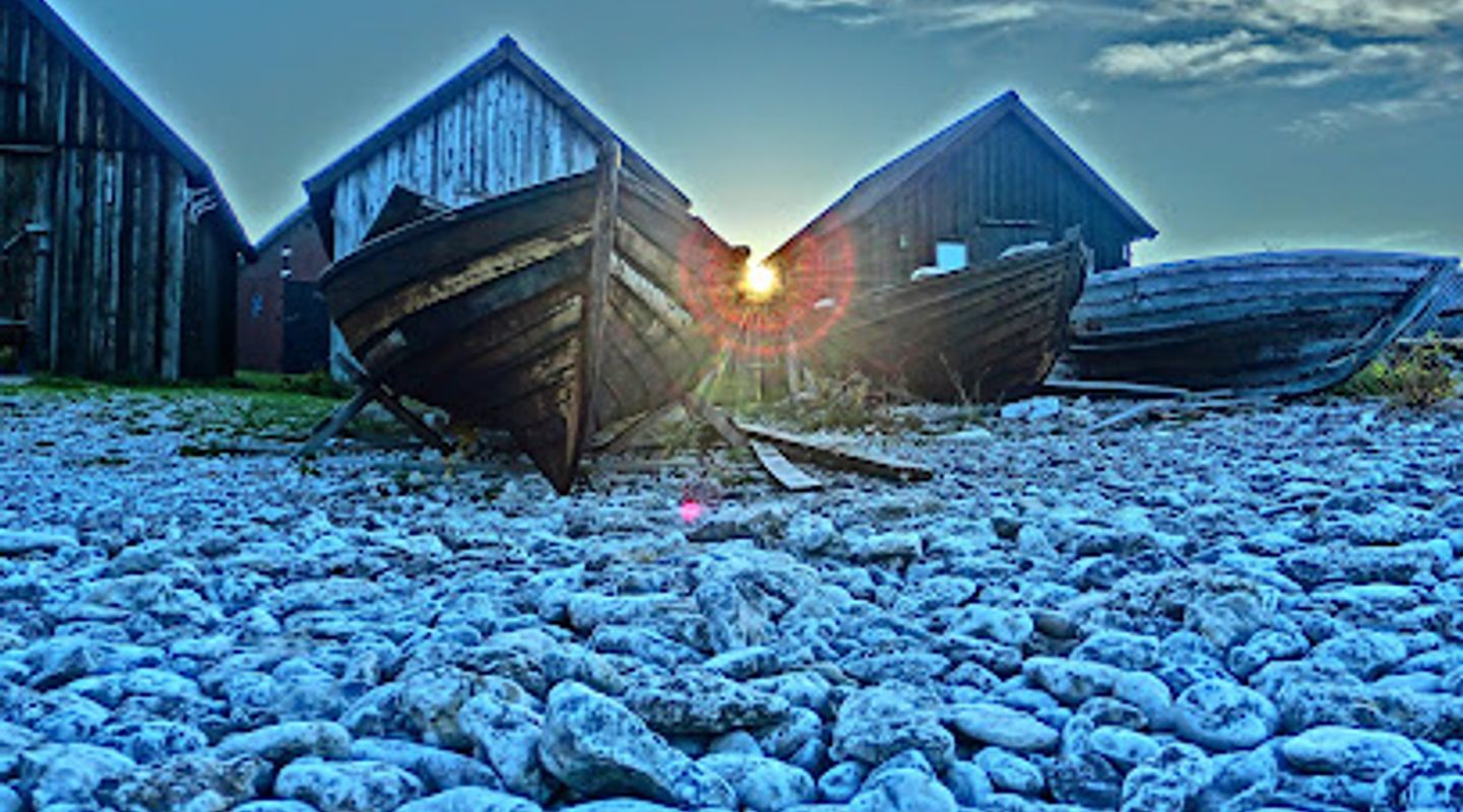
Free Guide: Swept by Baltic wind, Digerhuvud’s vast rauk fields and fossil‑etched limestone reveal Fårö’s ancient reef landscape and dramatic seaside textures.


A brief summary of Digerhuvud
Swept by Baltic wind, Digerhuvud’s vast rauk fields and fossil‑etched limestone reveal Fårö’s ancient reef landscape and dramatic seaside textures.
Digerhuvud is a windswept coastal nature reserve on Fårö famed for Sweden’s largest rauk (sea stack) field, stretching along the island’s northwest shore. The reserve features bands of rocky rauks rising up to about 8 metres, a low cliff, a broad shingle (klapperstens) plain and wind‑stunted beach pines; its fossil‑rich Silurian limestone reveals the island’s ancient reef origins and makes the shoreline a sculpted, tactile landscape for slow exploration.
On-site amenities
 Restrooms
 Seating areas
 Picnic areas
 Information boards
Opening hours
- Every dayOpen 24 hours
Opening hours as listed on the venue’s Google Business Profile. Hours can change for services and special events, so check with the venue before you go.
- Address
- 624 66 Fårö
- Website
Getting there
By car
Public transport + walk
Cycling
Discover more about Digerhuvud
A landscape carved by deep time
Digerhuvud’s story is written in stone: the reserve’s raukar are the weather‑worn remnants of coral reefs that formed roughly 430 million years ago during the Silurian, later exposed and sculpted by post‑glacial sea action. Hard reef limestone resisted erosion while surrounding softer layers were worn away, leaving isolated pillars and stacks that today punctuate the shore; many of these rocks retain visible fossils of corals, brachiopods and other marine life, a geological archive beneath your fingertips.
The shoreline sequence you’ll encounter
Moving seaward the terrain arranges itself in clear bands. Outermost raukar stand isolated, sometimes a short way offshore and still being worked by the waves. Behind them lies a low cliff and then a broad klapperstensfält — a cobble plain up to around 200 metres wide where vegetation is scarce and the ground is a mosaic of smooth stones. Further inland a sparse, wind‑shaped belt of beach pines and dune flora marks the transition to the island’s interior, offering shelter from the steady Baltic winds.
Raukar: variety and character
Raukar here vary in scale and personality: squat columns, narrow pillars, and blocky stacks reach heights of a few metres up to about eight metres, each with its own surface textures and hollows. Some provide convenient perches or natural windbreaks; others sit in the shallows where the sea continues to sculpt their bases. The long coastal stretch contains numerous discrete rauk fields so you can usually find a quieter cluster even on busier days.
Sensory details and seasonality
The reserve has a raw, elemental feel: salt‑sharp air, the constant hiss of wind and surf, the chalky scent of limestone and the tactile coolness of fossil‑pocked rock under your hands. Light changes the scene dramatically — low winter sun brings raking shadows across the cobbles while summer evenings can produce striking colours on the stones and sea. Birdsong is intermittent; seabirds, shorebirds and passage migrants use the coast at different times of year.
Conservation, rules and local character
Digerhuvud has protected status to conserve its geological and ecological values. The rauks and shore formations are delicate in their own way: removing or chipping at rock, collecting fossils, damaging vegetation, lighting fires outside designated places or driving off designated roads is incompatible with the reserve’s protections. The reserve is a working natural landscape on private and managed land, and its character is one of preservation, quiet exploration and low‑impact use.
What makes a visit here distinct
This is a place where geology reads like a map of ancient seas and the shoreline feels both sculptural and accessible. The long, linear rauk fields offer variety over a short distance—clusters of stacks, open cobble flats and patches of wind‑pressed pine — so a single visit can include tactile rock study, atmospheric sea views and moments of sheltered calm. The combination of fossil‑rich limestone, extensive rauk stretches and open Baltic horizon gives Digerhuvud a singular coastal identity.
Evendo Review Centre
 Google
Guest reviews
Best time to go
Quietest: Jan, Feb & Dec · before 6am or at 10pm
Busy times are Evendo estimates for a typical year, to help you plan. Actual crowds vary with events, school holidays and the weather.
Explore Digerhuvud on the map
A handpicked selection of must-see spots near Digerhuvud, mapped for you.
Get your free copy of our complete guide to Digerhuvud, delivered straight to you.
Everything on this page, from opening hours and how to get there to Eve’s tips and the best time to go, in one PDF you can read offline, print or share.
Already have an account? Sign in
Your Digerhuvud guide is ready.
We'll send it to · Not you? Sign out

Getting your guide ready…
We are putting together a fresh copy of the Digerhuvud guide. This can take up to a minute.
This can take a few moments. If your browser asks, choose Allow so the download can start. You'll find the guide in your Downloads folder.
Nothing happened? Download it again
Sorry, the guide is taking longer than usual. Please try again in a minute, or get it by email instead.
Other nearby places you may find interesting
The closest places of the same kind, if this one is not quite what you had in mind.
-
-
-
-
-


Swipe for more places
More to explore near Digerhuvud

 Best experiences near Digerhuvud
 Best hotels near Digerhuvud
 Best landmarks near Digerhuvud
 Best attractions near Digerhuvud
 Best shops near Digerhuvud
 Best restaurants near Digerhuvud
 Best bars near Digerhuvud
Do you manage this location?
Take control to get all the benefits, like improved information, better appearance, and stronger visibility across AI-powered discovery.
Explore more
Explore more of Götaland
Discover Götaland: Explore Southern Sweden's Rich History, Breathtaking Landscapes, and Vibrant Culture
Explore Götaland
Explore more of Sweden
Discover Sweden's breathtaking landscapes, vibrant cities, and rich cultural heritage. From the Northern Lights to historic castles, experience the essence of Scandinavia.
Explore Sweden
