

Flatruetvägen Travel Guide
Free Guide: A high, open plateau road that offers immediate access to Sweden’s dramatic treeless fjäll and wide alpine panoramas.


A brief summary of Flatruetvägen
A high, open plateau road that offers immediate access to Sweden’s dramatic treeless fjäll and wide alpine panoramas.
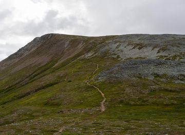
Flatruetvägen is the high mountain road that crosses the Flatruet plateau in western Härjedalen, offering expansive alpine tundra, dramatic horizons and simple roadside access to a vast, treeless fjäll landscape near Ljungdalen. The route is celebrated for its panorama, seasonal contrasts and as an easy way to step from the car onto open mountain heath and reindeer country.
On-site amenities
 Seating areas
 Information boards
 Trash bins
Opening hours
- Every dayOpen 24 hours
Opening hours as listed on the venue’s Google Business Profile. Hours can change for services and special events, so check with the venue before you go.
- Address
- Flatruetvägen, 845 99 Ljungdalen
- Phone
- Website
Getting there
By car
Public transport plus taxi
Guided transfer or organised excursion
Discover more about Flatruetvägen
A road that becomes a plateau
Flatruetvägen is not a single building or viewpoint but a roadway that culminates on the Flatruet plateau, where the motor route widens into parking clearings, memorial stones and viewpoints from which the landscape falls away in long, low undulations. Here the asphalt gives way visually to a wide, treeless tundra of heather, lichen and low dwarf birch; the road crossing has the scale of a natural threshold, the last sign of human infrastructure before miles of open fjäll. The skyline is broad and low, and weather moves in fast across the exposed slopes.
Landscape, wildlife and seasonal moods
The plateau sits at high elevation and is dominated by alpine heath and wind‑sculpted hummocks; in summer, carpets of purple fireweed and pockets of grass shimmer under long daylight, while autumn brings a crisp, russet hush. Winter compresses the scene into a white, sculpted world where the road is often closed at night and where drift and glare shape travel decisions. Reindeer are commonly seen grazing or moving in small groups; birds adapted to open country wheel on thermals and at times the plateau cups unexpected silence.
Human traces and small memorials
Along the roadside there are simple human markers: a modest monument commemorating the roadbuild, rest clearings with interpretive plaques and occasional handcrafted farming or Sámi markers set by local communities. These details are modest in scale but remind visitors that the plateau is stitched into a working cultural landscape — grazing, seasonal movement and mountain livelihoods continue alongside recreational use.
The straightforward visitor experience
Visiting Flatruetvägen is an uncomplicated, sensory experience: you drive, park and step out into open air. There are no formal trails radiating from the central rest areas so exploration often means picking a direction across low heaths and rock; footwear should suit uneven, often wet ground in summer and wind‑packed snow in colder months. Because the site is essentially an exposed mountain pass, weather is the defining factor of any visit and can change rapidly from calm sunshine to squall within an hour.
Why the road matters
Flatruetvägen is important because it provides rare, easy access to high mountain terrain without long approach walks. It functions as a landscape threshold: a place where the managed world ends and the open fjäll begins. For travellers it is both a practical connector between valleys and a deliberately simple attraction — a place to inhale altitude, watch weather, and experience a broad, northern horizon that feels larger than the map that contains it.
Practical notes on atmosphere and timing
Light and visibility shape the mood here: late‑summer evenings stretch long and gentle; autumn brings sharp light and colour; winter compresses perception into black silhouettes on white. Wind and temperature swings are typical; at times the plateau feels utterly empty and at other moments the roadside becomes a short, sociable stopping point for other travellers, photographers and outdoor enthusiasts preparing to walk a short way onto the fjäll.
Evendo Review Centre
 Google
Guest reviews
Best time to go
Quietest: Jan, Feb & Dec · at 1am or at 2am or at 3am
Busy times are Evendo estimates for a typical year, to help you plan. Actual crowds vary with events, school holidays and the weather.
Explore Flatruetvägen on the map
A handpicked selection of must-see spots near Flatruetvägen, mapped for you.
Get your free copy of our complete guide to Flatruetvägen, delivered straight to you.
Everything on this page, from opening hours and how to get there to Eve’s tips and the best time to go, in one PDF you can read offline, print or share.
Already have an account? Sign in
Your Flatruetvägen guide is ready.
We'll send it to · Not you? Sign out

Getting your guide ready…
We are putting together a fresh copy of the Flatruetvägen guide. This can take up to a minute.
This can take a few moments. If your browser asks, choose Allow so the download can start. You'll find the guide in your Downloads folder.
Nothing happened? Download it again
Sorry, the guide is taking longer than usual. Please try again in a minute, or get it by email instead.
Other nearby places you may find interesting
The closest places of the same kind, if this one is not quite what you had in mind.
-
-
-
-
-


Swipe for more places
More to explore near Flatruetvägen

 Best experiences near Flatruetvägen
 Best hotels near Flatruetvägen
 Best landmarks near Flatruetvägen
 Best attractions near Flatruetvägen
 Best shops near Flatruetvägen
 Best restaurants near Flatruetvägen
 Best bars near Flatruetvägen
Do you manage this location?
Take control to get all the benefits, like improved information, better appearance, and stronger visibility across AI-powered discovery.
Explore more
Explore more of Härjedalen
Explore Härjedalen: Sweden's untouched wilderness, offering year-round adventure and serene landscapes, perfect for nature lovers and thrill-seekers alike.
Explore Härjedalen
Explore more of Sweden
Discover Sweden's breathtaking landscapes, vibrant cities, and rich cultural heritage. From the Northern Lights to historic castles, experience the essence of Scandinavia.
Explore Sweden
