From Eve
Know before you go
Hi, I'm Eve. Here are a few practical things to know before exploring Tatamailau.
Local know-how to help you travel smarter and make the most of every moment.

Experience the breathtaking beauty of Tatamailau, the highest peak in Timor Leste, offering stunning views and unforgettable trekking adventures.
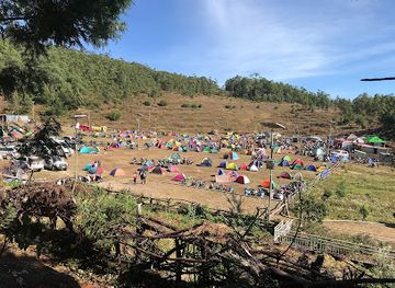
Tatamailau, the highest mountain in Timor Leste, is a breathtaking destination for adventurous tourists looking to explore stunning landscapes and rich biodiversity. Known for its challenging trails and awe-inspiring views, this peak offers an unforgettable experience for trekkers and nature enthusiasts alike.
Opening times, essentials, and a few local tips gathered into one calmer, easier-to-scan planning section.
Hi, I'm Eve. Here are a few practical things to know before exploring Tatamailau.
Local know-how to help you travel smarter and make the most of every moment.
Car
From Cova Lima, start by heading north on the main road (Avenida da Independência). Continue straight for about 20 kilometers until you reach the junction with Route 1. At this junction, turn left onto Route 1, which will take you towards Ainaro. Follow Route 1 for approximately 30 kilometers. Keep an eye out for signs directing you to Tatamailau. As you approach the mountain, you will see signs for the trailhead where you can park your car. The area may have minimal parking fees, so be prepared with small denominations of local currency.
Public Transportation
If you're taking public transportation, you will need to find a local bus or shared taxi (mikrolet) that goes to Ainaro. These typically depart from the main bus station in Cova Lima. The fare should be around $2-3 USD. Let the driver know you are going to Tatamailau. After about an hour's ride, you will reach Ainaro. From Ainaro, you may need to hire a local taxi or arrange for a motorcycle taxi to take you to the trailhead of Tatamailau. Expect to pay around $10-15 USD for this part of the journey.
Hiking
Once you reach the trailhead after parking your vehicle or getting dropped off by a taxi, you will begin your hike to Tatamailau. The trail is well-marked, but be prepared for a challenging ascent. The hike can take 2-4 hours depending on your fitness level and pace. Make sure to carry sufficient water, snacks, and wear appropriate hiking gear. There are no entrance fees for hiking, but donations may be appreciated by local guides if you choose to hire one for assistance.
Use Tower Bridge as your starting point for nearby food, family ideas, nightlife, and more local discoveries.

Explore expert travel guides, compare and book tours, experiences, hotels, and more—all from the palm of your hand. Download now for seamless trip planning wherever your wanderlust takes you.