

Boka Tabla, Curacao Travel Guide
Discover Boka Tabla in Curacao, where the Caribbean Sea meets limestone cliffs, creating a symphony of waves in Shete Boka National Park.
Boka Tabla, a stunning natural wonder located in Shete Boka National Park, is one of Curacao’s most breathtaking attractions. Known for its dramatic coastline, this destination showcases the raw power of the Caribbean Sea as waves crash into the limestone cliffs, creating a mesmerizing spectacle. The main draw here is the sea cave, accessible via a narrow staircase, where visitors can watch the waves thunderously roll in and feel the cool mist on their faces. The park itself spans over ten kilometers of rugged coastline and is home to several ‘bokas’ (inlets), each with its own unique charm. Boka Tabla is the most famous among them, but it’s worth exploring the other inlets like Boka Pistol and Boka Wandomi for their equally stunning views and geological formations. The area is also a sanctuary for nesting sea turtles, making it a haven for wildlife enthusiasts. Hiking trails around Boka Tabla offer panoramic views of the coast and the opportunity to see a variety of native plants and birds. Whether you’re an adventure seeker, a nature lover, or a photography buff, Boka Tabla provides an unforgettable experience that captures the wild beauty of Curacao.

Know before you go
Hi, I'm Eve. Here are a few practical things to know before exploring Boka Tabla.
- Visit early in the morning to avoid the heat and crowds.
- Wear sturdy shoes as the terrain can be uneven and rocky.
- Bring a hat and sunscreen, as there is limited shade in the area.
- Carry plenty of water, especially if you plan to hike the trails.
- Don’t forget your camera for capturing the dramatic landscapes.
- Check the park’s opening hours and any entry fees before you go.
Explore Boka Tabla: Things to Do, Places to Eat, Hotels & More
Handpicked recommendations for top attractions, local dining, accommodations, and more

Best attractions in Boka Tabla
Top-rated picks
Best Attractions
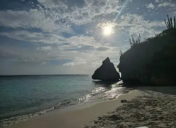
Flying Rock
Experience the breathtaking beauty of Flying Rock at Cas Abao beach, where tranquility meets adventure in the stunning landscape of Curaçao.

Hati cave
Explore Hati Cave in Willemstad, Curaçao - a stunning natural wonder filled with rich history and breathtaking rock formations.

Best landmarks in Boka Tabla
Top-rated picks
Best Landmarks

Fort Beekenburg
Explore Fort Beekenburg in Curaçao: a historic Dutch fort with stunning views of Spanish Water, offering a glimpse into the island's colonial past.

Punda Love Heart
Discover the charm of Punda Love Heart in Willemstad, Curaçao, where vibrant culture meets stunning waterfront views in a picturesque setting.

Boka Patrick
Discover Boka Patrick in Curaçao: a serene escape with stunning cliffs, turquoise waters, and vibrant marine life. Perfect for nature lovers!

Boka Grandi
Explore the stunning beauty of Boka Grandi, a captivating nature preserve in Labadera, Curaçao, perfect for adventure seekers and nature lovers alike.

Best restaurants in Boka Tabla
Top-rated picks
Best Restaurants

Zanzibar Beach & Restaurant
Experience stunning ocean views and delightful cuisine at Zanzibar Beach & Restaurant in Curaçao – your ultimate beach getaway.

Pirate Bay Curaçao Beach Club and Restaurant
Experience stunning ocean views and vibrant atmosphere at Pirate Bay Curaçao Beach Club & Restaurant - where delicious cuisine meets paradise.

Restaurant & Café Gouverneur De Rouville
Experience the flavors of Curaçao at Restaurant & Café Gouverneur De Rouville – where local charm meets culinary excellence.

La Bohème Curaçao
Discover La Bohème Curaçao: A culinary paradise blending Caribbean flavors and vegetarian delights in vibrant Willemstad.

Best bars in Boka Tabla
Top-rated picks
Best Bars

Daaibooi Beach Bar
Experience the charm of Daaibooi Beach Bar in Curaçao, where stunning ocean views meet delicious tropical drinks for an unforgettable getaway.

Netto Bar
Discover the vibrant nightlife of Curaçao at Netto Bar, where great drinks and a lively atmosphere await you.

Koraal Rooftop Terrace
Experience the stunning views and exquisite cuisine at Koraal Rooftop Terrace in Curaçao, where culinary delights meet breathtaking ambiance.

La Fogata Terrace & Sports Bar
Experience the vibrant flavors of Curaçao at La Fogata Terrace & Sports Bar, a top grill destination in Willemstad with a lively atmosphere.

Best shops in Boka Tabla
Top-rated picks
Best Shops

Renaissance Mall & Rif Fort
Discover the Renaissance Mall & Rif Fort, where shopping meets history in the heart of Willemstad, offering unique shops and delightful dining options.

Sambil Curacao
Discover the vibrant shopping and dining scene at Sambil Curacao, a premier destination for tourists in Willemstad, featuring an array of local and international brands.

Zuikertuin Mall
Discover the ultimate shopping experience at Zuikertuin Mall in Willemstad, where modern retail meets local charm.

La Curacao
Discover La Curacao, a premier department store in Willemstad, Curaçao, offering a diverse selection of products for every shopping need.

Explore Boka Tabla on the Map
A handpicked selection of must-see spots in Boka Tabla, mapped for you.
Boka Tabla Essentials
-
Boka Tabla is located in Shete Boka National Park in Curacao. The nearest international airport is Hato International Airport, approximately 40 kilometers away. From the airport, you can rent a car or take a taxi to reach the park. The drive typically takes around 45 minutes by road. Public transportation options are limited, so renting a car is often the most convenient option.
-
Curacao's public transport system is limited, and Boka Tabla is best accessed by car. Car rentals are available at Hato International Airport and in Willemstad, the capital city. Taxis are also an option, but they can be expensive for longer distances. It is advisable to rent a car to explore the island and reach Boka Tabla easily. There is ample parking available at Shete Boka National Park.
-
The official currency in Curacao is the Netherlands Antillean Guilder (ANG). US Dollars are widely accepted, and major credit cards are accepted at most hotels, restaurants, and shops. However, it is advisable to carry some cash, especially for small purchases and in rural areas. ATMs are available in Willemstad and other major towns.
-
Curacao is generally a safe destination for tourists, but it is advisable to take standard precautions. Avoid leaving valuables in plain sight in your car and be cautious in crowded areas. Some neighborhoods in Willemstad, such as Punda and Otrobanda, have higher crime rates, especially at night. Always stay vigilant and aware of your surroundings.
-
In case of emergency, dial 911 for immediate assistance. The local police station and medical facilities are available in Willemstad. It is recommended to have travel insurance that covers medical emergencies. For minor health issues, there are pharmacies in Willemstad where you can purchase over-the-counter medications.
-
Fashion: Do wear light, breathable clothing suitable for the tropical climate. Don't wear overly revealing clothing, especially when visiting religious or cultural sites. Religion: Do respect local customs and traditions. While Curacao is religiously diverse, it is important to be respectful when visiting places of worship. Public Transport: Do be respectful and courteous to other passengers. Public transport options are limited, so plan accordingly. Greetings: Do greet people with a friendly 'Bon dia' (Good morning) or 'Bon tardi' (Good afternoon). A handshake is also customary. Eating & Drinking: Do try local dishes such as 'keshi yena' and 'stobá'. Don't refuse hospitality, as it is considered impolite.
-
To experience Boka Tabla like a local, visit early in the morning to avoid the crowds and the heat. Engage with the park rangers, who are often knowledgeable and willing to share information about the area's natural history and geology. Bring sturdy footwear for exploring the rocky coastlines and caves. Don't miss the opportunity to visit other nearby attractions in Shete Boka National Park, such as Boka Pistol and Boka Wandomi, which offer spectacular views and unique geological features.
When is the best time to visit Boka Tabla?
Useful Local Phrases for Boka Tabla
You don't need to speak the language perfectly. Even learning a few simple words can make conversations warmer—and locals usually appreciate the effort.
— Eve

Here are the phrases I use most often in Boka Tabla. Try a few—you'll be surprised how far they go! 😊
❤️
-
- HelloBon dia
[bon dee-ah] - GoodbyeAyo
[ah-yo] - YesSi
[see] - NoNo
[no] - Please/You're welcomePor fabor
[por fa-bor] - Thank youDanki
[dan-kee] - Excuse me/SorryPardon
[par-don] - How are you?Kon ta bai?
[kon ta bah-ee] - Fine. And you?Bon. I boso?
[bon. ee boh-soh?] - Do you speak English?Bo papia Ingles?
[boh pa-pee-ah een-gles?] - I don't understandMi no kompronde
[mee no kom-pron-deh]
- HelloBon dia
-
- I'd like to see the menu, pleaseMi ke mira e menu, por fabor
[mee keh mee-rah eh meh-noo, por fa-bor] - I don't eat meatMi no kome karni
[mee noh koh-meh kar-nee] - Cheers!Salud!
[sah-lood] - I would like to pay, pleaseMi ke paga, por fabor
[mee keh pah-gah, por fa-bor]
- I'd like to see the menu, pleaseMi ke mira e menu, por fabor
-
- Help!Yudami!
[yoo-dah-mee] - Go away!Bai bai!
[bah-ee bah-ee] - Call the Police!Yama polis!
[yah-mah poh-lees] - Call a doctor!Yama un dokter!
[yah-mah oon dohk-ter] - I'm lostMi a pèrdi
[mee ah pair-dee] - I'm illMi ta malu
[mee tah mah-loo]
- Help!Yudami!
-
- I'd like to buy...Mi ke kumpra...
[mee keh koom-prah] - I'm just lookingMi ta mira solamente
[mee tah mee-rah soh-lah-men-teh] - How much is it?Kuantu e kos ta?
[kwan-too eh kohs tah?] - That's too expensiveEsaki ta muchu karu
[eh-sah-kee tah moo-choo kah-roo] - Can you lower the price?Bo por baha e preis?
[boh poor bah-hah eh preis?]
- I'd like to buy...Mi ke kumpra...
-
- What time is it?Kuantu ora e ta?
[kwan-too oh-rah eh tah?] - It's one o'clockTa un ora
[tah oon oh-rah] - Half past (10)Mitad di dies
[mee-tahd dee dees] - MorningMarduga
[mar-doo-gah] - AfternoonAtardi
[ah-tar-dee] - EveningAnochi
[ah-noh-chee] - YesterdayAyera
[ah-yeh-rah] - TodayAwe
[ah-weh] - TomorrowMañana
[mah-nyah-nah] - 1Uno
[oo-no] - 2Dos
[dohs] - 3Tres
[trehs] - 4Kuater
[koo-ah-ter] - 5Sinku
[seen-koo] - 6Seis
[says] - 7Siete
[syeh-teh] - 8Ocho
[oh-choh] - 9Nuebe
[nweh-beh] - 10Dies
[dees]
- What time is it?Kuantu ora e ta?
-
- Where's a/the...?Unda tin un/e...
[oon-dah teen oon/eh...] - What's the address?Kiko e adres ta?
[kee-koh eh ah-dres tah?] - Can you show me (on the map)?Bo por mustra mi (riba e mapa)?
[boh poor moos-trah mee (ree-bah eh mah-pah)?] - When's the next (bus)?Ku ora ta bini e siguiente (bus)?
[koo oh-rah tah bee-nee eh see-gwee-en-teh (boos)?] - A ticket (to ....)Un tikit (pa ....)
[oon tee-keet (pah ....)]
- Where's a/the...?Unda tin un/e...
History of Boka Tabla
-
Boka Tabla, located in Shete Boka National Park on the rugged northern coast of Curaçao, was formed over millennia through the relentless pounding of ocean waves against the island's limestone cliffs. The inlet is named 'Boka', meaning 'mouth' in Papiamentu, the local language, due to its resemblance to an open mouth engulfing the sea. This natural wonder showcases the island's geological history and the dynamic natural forces at play.
-
Long before European colonization, the Arawak and Caiquetio people inhabited Curaçao, including the area around Boka Tabla. These indigenous groups relied on the sea for sustenance and lived in harmony with the natural environment. Archaeological findings in the region, including pottery and tools, provide a glimpse into their way of life. Boka Tabla and the surrounding coastal areas would have been vital for fishing and gathering resources.
-
In 1499, Spanish explorer Alonso de Ojeda, accompanied by Amerigo Vespucci, arrived on the shores of Curaçao, marking the beginning of European interest in the island. The Spanish initially found little value in Curaçao due to its arid landscape and lack of gold. However, they noted the strategic importance of its coastal features like Boka Tabla. The Spanish eventually deported the indigenous population to work in copper mines on Hispaniola, leaving the island sparsely populated.
-
In 1634, the Dutch West India Company seized Curaçao from the Spanish, recognizing its potential as a trade hub. Under Dutch control, the island flourished, and its natural harbors, including areas around Boka Tabla, became crucial for maritime activities. The Dutch established Willemstad as a major port city, and Curaçao became a center for trade, including the transatlantic slave trade. The island's economy boomed during this period, and the coastal routes were essential for navigation and commerce.
-
During the 17th and 18th centuries, the Caribbean was rife with pirate activity, and Curaçao was no exception. The secluded inlets and caves around Boka Tabla provided perfect hideouts for pirates and smugglers. These maritime outlaws took advantage of the natural terrain to evade capture and stash their loot. Legends of buried treasures and pirate escapades are still part of the local folklore, adding a layer of mystery to the area's history.
-
In 1994, Shete Boka National Park was established to protect the unique coastal environment and its ecosystems, including Boka Tabla. The park spans over 10 kilometers of coastline and comprises several 'bokas', each with its own distinct features. The establishment of the park marked a significant step in preserving the natural and cultural heritage of the area. Today, Boka Tabla is a popular tourist destination, attracting visitors with its stunning sea caves, dramatic waves, and rich history.
-
Today, Boka Tabla is a renowned natural attraction within Shete Boka National Park. Visitors can explore the sea cave, witness the powerful waves crashing against the cliffs, and enjoy panoramic views of the coastline. The site also serves as an educational resource, offering insights into the geological processes that shaped the island and the historical events that occurred here. Boka Tabla continues to be a symbol of Curaçao's natural beauty and cultural legacy.
Cities in Boka Tabla
Browse our curated selection of top destinations, scenic points, and must-visit spots in the area.


Neighbouring destination travel guides
Browse our curated selection of top destinations, scenic points, and must-visit spots in the area.




Your all‑in‑one travel companion app
Explore expert travel guides, compare and book tours, experiences, hotels, and more—all from the palm of your hand. Download now for seamless trip planning wherever your wanderlust takes you.


Explore More of Sta. Catharina

Looking beyond Boka Tabla? Discover Sta. Catharina for broader travel guides, local hot-spots, and regional highlights.
Explore Sta. CatharinaExplore More of Curacao

Looking beyond Boka Tabla? Discover Curacao for broader travel guides, local hot-spots, and regional highlights.
Explore CuracaoBoka Tabla in Photos
Browse through our photo collection highlighting the charm and character of the destination.

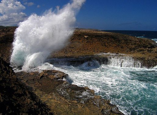


Boka Tabla: Nature’s Dramatic Symphony in Curacao
Boka Tabla, a stunning natural wonder located in Shete Boka National Park, is one of Curacao’s most breathtaking attractions. Known for its dramatic coastline, this destination showcases the raw power of the Caribbean Sea as waves crash into the limestone cliffs, creating a mesmerizing spectacle. The main draw here is the sea cave, accessible via a narrow staircase, where visitors can watch the waves thunderously roll in and feel the cool mist on their faces. The park itself spans over ten kilometers of rugged coastline and is home to several ‘bokas’ (inlets), each with its own unique charm. Boka Tabla is the most famous among them, but it’s worth exploring the other inlets like Boka Pistol and Boka Wandomi for their equally stunning views and geological formations. The area is also a sanctuary for nesting sea turtles, making it a haven for wildlife enthusiasts. Hiking trails around Boka Tabla offer panoramic views of the coast and the opportunity to see a variety of native plants and birds. Whether you’re an adventure seeker, a nature lover, or a photography buff, Boka Tabla provides an unforgettable experience that captures the wild beauty of Curacao.