Background

Geografisk Knudepunkt

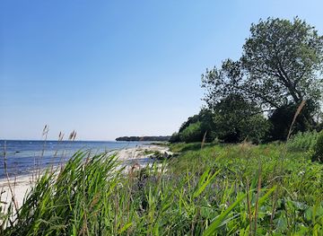
Where latitude and longitude meet: Denmark's geographic heart on the Bornholm coast.

4.5

A granite marker in the coastal dunes of southern Bornholm marks the precise intersection of the 55th parallel north and the 15th meridian east—the geographic point that defines Danish standard time. Located near the historic Slusegård watermill and within the protected Østre Sømarken nature area, this modest but significant landmark offers visitors a tangible connection to global geography and a gateway to exploring one of Denmark's most distinctive regions.

A brief summary to Geografisk knudepunkt

  • Strandvejen 10, Aakirkeby, 3720, DK
  • Visit website
  • Duration: 0.5 to 2 hours
  • Free
  • Environment icon Outdoor
  • Mobile reception: 4 out of 5

Local tips

  • Visit during clear weather to fully appreciate the expansive coastal views and the symbolic significance of standing at this precise geographic intersection.
  • Combine your visit with the nearby Slusegård watermill and Østre Sømarken nature trails to experience the full cultural and natural heritage of the area.
  • The area is privately owned but protected for public access; respect the landscape and follow marked trails to preserve the delicate coastal heathland ecosystem.
  • Bring binoculars to observe the diverse birdlife in the coastal dunes and marshland, particularly during migration seasons in spring and autumn.
widget icon

Getting There

  • Car from Aakirkeby

    From Aakirkeby town center, drive south on Strandvejen toward the coast. The journey takes approximately 10–15 minutes covering roughly 5 kilometers. Follow signs toward Slusegård. Parking is available near Slusegård watermill and Café Slusegård, from which the geographic marker is a short walk of 100 meters across the protected heathland. No entrance fee is required.

  • Walking from Slusegård

    From Slusegård watermill and café, the granite marker is located 100 meters south across open grassland and low dunes. The walk takes approximately 5–10 minutes on level terrain with no significant obstacles. The path is informal but well-trodden. This is the most direct approach and allows you to visit both the marker and the historic watermill in a single outing.

  • Hiking from Bakkerne Havn

    From the small fishing settlement of Bakkerne Havn to the east, walking trails through Østre Sømarken connect to the geographic point. The walk takes approximately 20–30 minutes depending on your route and pace. This approach allows you to experience the full coastal heathland landscape and observe the transition from settlement to open nature. Trails are marked and maintained.

  • Cycling from Nexø

    From Nexø, approximately 12 kilometers away, cycling via Strandvejen takes 25–35 minutes depending on fitness and route. The road is generally flat with some gentle slopes. Bike parking is available near Slusegård. This option suits those wanting a longer outdoor experience while visiting multiple coastal attractions in the area.

Geografisk knudepunkt location weather suitability

  • Weather icon Clear Skies
  • Weather icon Mild Temperatures
  • Weather icon Any Weather

Unlock the Best of Geografisk knudepunkt

Buy tickets

    No tickets available

Book tours with entry

    No tours available

Book tours without entry

    No tours available

Discover more about Geografisk knudepunkt

The Meeting Point of Latitude and Longitude

At the southern tip of Bornholm, where the 55th parallel north intersects with the 15th meridian east, lies a simple yet profound geographic marker. A granite stone embedded in the coastal dunes marks this exact point, where the sun reaches its highest position at noon (1 PM during summer months). This intersection holds particular significance for Denmark, as it defines the meridian upon which Danish standard time is based. The location sits approximately 100 meters south of Slusegård, within a protected landscape that has been carefully preserved to maintain public access and protect its natural and cultural heritage.

A Landscape Shaped by Time and Geology

The Østre Sømarken area surrounding the geographic point is a coastal heathland characterized by low dunes and open grassland, creating an expansive horizon that invites contemplation. The landscape tells stories of human settlement spanning millennia. During the Iron Age, this same ground hosted a substantial burial ground, evidence of Bornholm's importance as a wealthy and strategically significant cultural hub. The Øle Å stream flows through a narrow gorge of slate, its banks revealing fossilized impressions of ancient marine creatures called graptolites. Nearby stands a well-preserved watermill with dams dating to around 1800, alongside a historic trout house once used to catch spawning sea trout—remnants of the region's intimate relationship with water and sustenance.

Gateway to Coastal Heritage

Just east of the geographic point lies Bakkerne Havn, a small fishing settlement featuring traditional fishermen's houses and a smokehouse. The entire Slusegård area is protected as a nature reserve to safeguard the watermill complex and ensure public access to both the mill and the beach. This protection reflects the area's dual significance: as a natural landscape of ecological value and as a cultural monument representing centuries of human adaptation to coastal life. The combination of geographic precision and historic depth makes this location a unique vantage point from which to understand Bornholm's place in both the physical world and human history.

Exploring the Broader Sømarken Region

Visitors to the geographic point can extend their experience by walking through the Østre Sømarken nature area, which offers trails connecting the marker to the watermill, the stream gorge, and the coastal settlement. The landscape transitions from open heathland to wooded areas and down to the shoreline, revealing the environmental diversity that has sustained human communities here for thousands of years. The protected status of the area ensures that these ecosystems remain intact, allowing visitors to experience the landscape much as it has existed for generations. The combination of natural beauty, historical depth, and geographic significance creates a destination that appeals equally to those seeking solitude, outdoor exploration, and connection to place.

Busiest months of the year

Busiest hours of the day

Popular Experiences near Geografisk knudepunkt

Popular Hotels near Geografisk knudepunkt

Select Currency