From Eve
Know before you go
Hi, I'm Eve. Here are a few practical things to know before exploring Mols Bjerge National Park.
Local know-how to help you travel smarter and make the most of every moment.
Soft Danish “mountains” of heather and oak, Ice Age landforms, Bronze Age mounds and bright bays combine in one richly varied national park on Djursland.
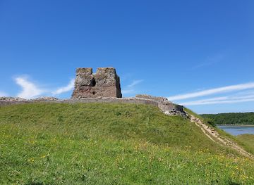
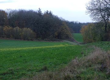
Spread across 180 sq km of glacially shaped hills, heathland, coastline and forest on the Djursland peninsula, Mols Bjerge National Park is one of Denmark’s most evocative landscapes. Rolling “mountains” rise to 137m with sweeping views over bays and inlets, Bronze Age burial mounds punctuate the ridgelines, and wild horses and grazing livestock help maintain rich biodiversity. Well-marked trails, including the 80km Mols Bjerge Trail, make this a superb area for hiking, cycling, nature watching and slow, contemplative exploration in all seasons.
Opening times, essentials, and a few local tips gathered into one calmer, easier-to-scan planning section.
Hi, I'm Eve. Here are a few practical things to know before exploring Mols Bjerge National Park.
Local know-how to help you travel smarter and make the most of every moment.
Car from Aarhus
From central Aarhus, driving to the main areas of Mols Bjerge typically takes 35–50 minutes, depending on which entrance or trailhead you choose. The route uses major regional roads suitable for all standard vehicles and is straightforward year‑round. Parking areas near Kalø Castle, Femmøller and key viewpoints are generally free, but some can fill up on sunny summer weekends and school holidays, so arriving earlier in the day offers more choice of spaces.
Bus from Aarhus region
Regional buses run between Aarhus and towns such as Rønde and Ebeltoft, which lie within or at the edge of the national park. Typical travel time is about 45–70 minutes depending on the route and destination. From these towns you can access nearby trailheads on foot or by local bus where available. Standard single adult fares on regional buses are usually in the range of 30–70 DKK, with tickets purchased from machines, drivers or travel apps depending on the service.
Cycling from Djursland towns
For confident cyclists already staying on Djursland, reaching Mols Bjerge by bike is an appealing low‑impact option. From Rønde or Ebeltoft, well‑signed local and national cycle routes lead into the park through gently hilly countryside. Expect 30–60 minutes of riding each way for many common starting points. Surfaces are a mix of paved roads and good gravel stretches, so a touring or hybrid bike is ideal. Strong winds and rolling terrain can make the ride moderately demanding, and lighting is recommended outside summer evenings.
Walking from nearby villages
If you are staying in accommodation close to the park boundary, such as in villages around Femmøller or along the coast, you can often start your visit on foot directly from your door. Allow 30–90 minutes of walking to reach central viewpoints, depending on your exact location and chosen route. Paths may include forest tracks, farm lanes and sometimes steeper hill sections, which can be slippery after rain. This option suits visitors comfortable with moderate distances and limited wayfinding using local signs and maps.
Catch the right light and the right mood, whether you want a bright city moment or a more cinematic evening visit.


Use Tower Bridge as your starting point for nearby food, family ideas, nightlife, and more local discoveries.
A quick look at seasonal patterns and peak visiting hours.

Explore expert travel guides, compare and book tours, experiences, hotels, and more—all from the palm of your hand. Download now for seamless trip planning wherever your wanderlust takes you.

Samsø: Explore Denmark's eco-friendly island, rich in natural beauty, culinary delights, and cultural heritage.
Tell me more about Samso