Background

Denmark’s Westernmost Point – Blåvandshuk

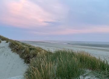
Wind-sculpted dunes, a steadfast lighthouse and endless North Sea horizons meet at Denmark’s westernmost point, where nature, history and energy converge at the edge of Jutland.

★★★★★4.9 (241)

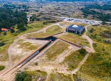
Denmark’s westernmost point, at Blåvandshuk on Jutland’s North Sea coast, is a windswept headland of dunes, sandy beaches and heathland backed by the white Blåvand Lighthouse. Here the North Sea, Wadden Sea and vast skies meet in a raw, scenic landscape shaped by storms, shifting sands and powerful currents. It is a place for long walks, birdwatching, sea views and contemplating the edge of the country amid traces of wartime bunkers and cutting‑edge offshore wind farms.

Plan your visit

A brief summary to Denmark's westernmost point

Opening times, essentials, and a few local tips gathered into one calmer, easier-to-scan planning section.

Plan your visit

📍
DK
🕒
Duration: 1 to 3 hours
💷
Free
🏛
Outdoor
📶
Mobile reception: 4 out of 5

Explore places near Denmark's westernmost point

    See all →

    Unlock the Best of Denmark's westernmost point

    Find tickets, tours with entry, and experiences available for this location.

    Buy tickets

    No tickets available

    Book tours with entry

    No tours with entry available

    Book tours without entry

    No tours without entry available

    Getting There

    Car from Esbjerg

    From Esbjerg city centre, driving to Blåvandshuk via the main regional roads typically takes about 40–50 minutes, depending on traffic and weather. The route follows well-maintained paved roads across flat countryside and through holiday areas near Blåvand. Parking near the lighthouse area is generally free, but in peak summer school holiday periods spaces can fill quickly. There are no tolls on this stretch, and fuel for the return trip will usually cost in the range of 80–150 DKK for a standard car, depending on consumption and current prices.

    Regional bus and walk from Esbjerg

    Public buses run between Esbjerg and the seaside town of Blåvand, with journeys typically taking around 1 hour 15 minutes to 1 hour 45 minutes including intermediate stops and potential changes. A standard adult ticket on regional buses usually costs roughly 40–80 DKK one way, depending on the exact zones and type of ticket purchased. From the bus stop in Blåvand, reaching the westernmost point requires a walk of around 45–60 minutes along local roads or the beach, over mostly flat but sometimes sandy terrain that may be challenging for wheelchairs or prams.

    Cycling from Varde area

    For experienced cyclists, reaching Blåvandshuk from the Varde area by bike along signposted local and national cycle routes typically takes 1.5–2.5 hours each way, depending on fitness and wind conditions. The landscape is mostly flat, but strong headwinds and occasional showers are common along the North Sea coast, so suitable clothing and a well-maintained bike are essential. There is no direct cost beyond bicycle rental if needed, which in this region often ranges from about 100–200 DKK per day, and basic roadside facilities between towns can be limited outside holiday seasons.

    For the on-the-go comforts that matter to you

    Restrooms
    Drink Options
    Drinking Water
    Food Options
    Seating Areas
    Sheltered Areas
    Trash Bins
    Information Boards
    Visitor Center

    Local tips

    Bring a windproof layer and hat even in summer; the exposed headland can feel several degrees cooler than inland due to strong coastal winds.
    Plan extra time to walk the beach around sunrise or late afternoon, when low light and long shadows make the dunes and lighthouse especially photogenic.
    If you enjoy birds, pack binoculars and check seasonal migration periods to make the most of the Wadden Sea flyway passing near Blåvandshuk.
    Footing in the dunes and on wet sand can be uneven; wear sturdy shoes and be cautious near the water’s edge in strong surf or stormy conditions.

    Denmark's westernmost point location weather suitability

    Catch the right light and the right mood, whether you want a bright city moment or a more cinematic evening visit.

    Weather icon
    Clear Skies
    Weather icon
    Windy Conditions
    Weather icon
    Mild Temperatures
    Weather icon
    Cold Weather
    Weather icon
    Hot Weather
    Weather icon
    Any Weather

    Discover more about Denmark's westernmost point

    Standing at the Edge of Denmark

    Denmark’s westernmost point lies at Blåvandshuk, a sandy headland jutting into the North Sea on the southwest coast of Jutland. Here the flat land of West Jutland gives way to a low, shifting landscape of dunes and wide beaches that feels very much like the country’s frontier. Out beyond the surf lies Horns Rev, a long sandbank that has challenged mariners for generations and helped shape the need for a powerful lighthouse. This is a place defined as much by empty space as by landmarks. The wind is almost a constant companion, pushing waves towards shore and driving fine sand along the beach. On clear days, the horizon seems to stretch forever, reinforcing the sense that you are standing at the last sliver of land before the open Atlantic.

    Blåvand Lighthouse and the Maritime Story

    The most striking structure is Blåvand Lighthouse, a tall, white concrete tower that has watched over these waters since 1900. Built to replace an earlier light, it was designed to warn ships of the treacherous Horns Reef, whose submerged sandbanks reach far out to sea. The lighthouse is Denmark’s westernmost building, and its lantern has long been a vital point of reference for sailors navigating this busy stretch of coast. From the area around the lighthouse, you can trace the maritime story in every direction: breakers rolling in from the North Sea, the outline of offshore wind turbines on the horizon, and the steady rhythm of seabirds following the coastline. The light station buildings nearby hint at a time when keepers lived on site, tending the lamp in all weather.

    Dunes, Heathland and Coastal Wildlife

    Away from the tower, Blåvandshuk reveals itself as a mosaic of marshland, moor, dunes and long ribbons of sand. The headland connects towards the Skallingen peninsula, part of a wider Wadden Sea environment of tidal flats, islands and shallow bays that is of major importance for migratory birds. Large flocks of waders, geese and seabirds pass through or overwinter here, making the area a rewarding stop for anyone with binoculars. The vegetation is tough and low, adapted to salty winds and sandy soil. Marram grass holds the dunes in place, while heather and scrubby bushes color the heath in muted purples and greens. In summer the air can be filled with the calls of larks and the distant boom of surf; in winter the landscape feels stark and stripped back, with a beauty that relies on light and weather more than lush greenery.

    Traces of Conflict in the Sand

    The apparently timeless natural setting is layered with reminders of more recent history. Along this stretch of coast, German forces built bunkers and fortifications during the Second World War as part of the Atlantic Wall. Some remain partly buried in the dunes, their concrete softened by sand and lichen but still clearly visible as reminders of a turbulent era. Further south on Skallingen, Denmark’s last minefield lingered for decades after the war, a stark illustration of how long conflict can echo in a landscape. Today, demining and protection work have turned the focus from defence to conservation, but the story of militarisation remains an important chapter in understanding Blåvandshuk.

    Wind, Energy and the Modern Coast

    Looking out to sea, you will often see rows of turbines from the Horns Rev offshore wind farms rising above the waves. These were among the pioneering large-scale offshore projects, harnessing the strong, steady winds of the North Sea to generate renewable power. Exhibitions in the wider Blåvand area explain how these installations fit into Denmark’s broader energy ambitions and how they coexist with marine life and shipping. The juxtaposition of an early‑20th‑century lighthouse and 21st‑century turbines captures the evolving relationship between this coast and the sea. Navigation, safety and energy are all woven into the story, giving Blåvandshuk a significance that goes beyond its role as a simple geographic extreme.

    Experiencing the Western Horizon

    For visitors, the appeal lies in both the drama and the quiet. Long walks along the 50‑kilometre stretch of broad, pale beach reveal shifting moods as light and weather change. Some come to watch powerful winter storms, others to enjoy mild summer evenings when the low sun turns dunes golden. The open views and constant sound of waves invite unhurried reflection. Whether you are interested in coastal nature, maritime heritage or simply the feeling of standing at the country’s edge, Denmark’s westernmost point offers space, sky and sea in generous measure. It rewards slow exploration, a good windproof jacket and a willingness to let the elements set the pace of your visit.

    Plan around the quieter times

    A quick look at seasonal patterns and peak visiting hours.

    Busiest months of the year

    Seasonality

    Busiest hours of the day

    Footfall
    Mobile App
    Get the app

    Your all‑in‑one travel companion app

    Explore expert travel guides, compare and book tours, experiences, hotels, and more—all from the palm of your hand. Download now for seamless trip planning wherever your wanderlust takes you.

    File:Kronborg 002.JPG - Wikimedia Commons

    More about Zealand

    Discover the charm of Zealand, Denmark's largest island, blending vibrant city life in Copenhagen with serene coastal beauty and rich cultural heritage.

    Tell me more about Zealand

    Select Currency

    Choose the currency you want prices to display in.