Background

Denmark’s Westernmost Point – Blåvandshuk

Stand at the windswept edge of Jutland, where dunes, lighthouse and roaring North Sea mark the far western horizon of Denmark.

4.8

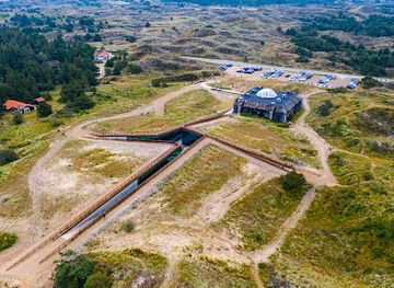
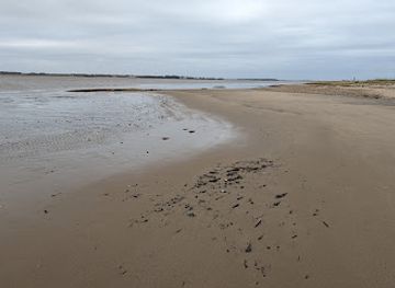
At Blåvandshuk, Denmark’s westernmost point, endless white-sand beaches, rolling dunes and the roaring North Sea meet at a windswept headland crowned by the 39 m Blåvandshuk Lighthouse. This wild stretch of Jutland’s west coast offers sweeping views towards Horns Rev and its vast offshore wind farm, remnants of WWII bunkers half-buried in the sand, and access to protected Wadden Sea landscapes of heath, marsh, and migrating birds. It is a place for salty walks, big skies, and a tangible sense of reaching the very edge of Denmark.

A brief summary to Denmark's westernmost point

  • DK
  • Duration: 1 to 3 hours
  • Free
  • Environment icon Outdoor
  • Mobile reception: 4 out of 5
  • Monday 12 am-12 am
  • Tuesday 12 am-12 am
  • Wednesday 12 am-12 am
  • Thursday 12 am-12 am
  • Friday 12 am-12 am
  • Saturday 12 am-12 am
  • Sunday 12 am-12 am

Local tips

  • Bring a windproof layer year‑round; the exposed headland can feel significantly colder than inland, even on sunny days.
  • If you plan to climb the lighthouse, check opening times and carry a small bank card or cash for the entry fee.
  • Allow extra time to walk through soft sand from parking areas to the beach and dunes, especially if travelling with small children.
  • Stay for sunset on clear evenings to see the sky blaze over the North Sea and the lighthouse beam cutting through the twilight.
  • Respect fences and signs around protected dunes and Wadden Sea areas; the fragile habitat is crucial for birds and coastal wildlife.
widget icon

Getting There

  • Car from Esbjerg

    From central Esbjerg, driving to Blåvandshuk via the main west coast route typically takes 40–50 minutes, covering roughly 40–45 km on well‑maintained roads. There is no entrance fee for the headland itself, but expect to pay around DKK 10–20 per litre for fuel depending on current prices. Parking near the lighthouse and dunes is usually free, though spaces can be busy on peak summer weekends and in high winds sand may partly cover some smaller access roads.

  • Regional bus via Varde and Blåvand

    Public buses connect Esbjerg with Varde and onward to the holiday town of Blåvand, with combined journey times typically between 1 hour 15 minutes and 1 hour 45 minutes depending on connections and season. A single adult ticket for the full route usually costs in the region of DKK 60–90. From Blåvand, you can walk on firm pavements and sandy paths to the headland in about 45–60 minutes. Services are less frequent in the evening and on winter weekends, so check timetables in advance.

  • Cycling from Blåvand village

    From accommodation or campsites in and around Blåvand, many visitors cycle to Denmark’s westernmost point using local roads and signed paths that avoid heavy traffic. The ride generally takes 15–30 minutes each way, depending on starting point and wind conditions. There is no cost beyond bicycle rental, which in the area usually runs around DKK 80–150 per day. Strong coastal winds and blown sand can make cycling strenuous at times, and basic lights and reflective gear are advisable outside midsummer daylight hours.

Denmark's westernmost point location weather suitability

  • Weather icon Clear Skies
  • Weather icon Windy Conditions
  • Weather icon Mild Temperatures
  • Weather icon Cold Weather
  • Weather icon Hot Weather

Unlock the Best of Denmark's westernmost point

Buy tickets

    No tickets available

Book tours with entry

    No tours available

Book tours without entry

    No tours available

Discover more about Denmark's westernmost point

Where Denmark Finally Meets the Sea

Blåvandshuk is the dramatic headland that marks the westernmost point of metropolitan Denmark, thrusting into the North Sea at the tip of southwest Jutland. Here the mainland simply stops, yielding to a horizon of open water and shifting skies. The cape anchors a coastline of about fifty kilometres of pale, fine sand, backed by wind‑sculpted dunes and low, scrubby heath. On calm summer days the sea glitters gently; in winter, waves hammer the shore and the wind whips salt spray high into the air. This sense of being at the country’s outer limit is more than just geographical. The land feels pared back to essentials: sand, grass, water and sky. Stand on the dune crest and everything inland lies behind you; ahead is only the long swell of the North Sea and, far beyond, the memory of old shipping routes towards Britain.

The Lighthouse Above the Dunes

Crowning the headland is Blåvandshuk Lighthouse, a stark white tower that has watched over this coastline since 1900. Rising 39 metres from the ground and set on a high dune, it reaches about 55 metres above sea level, making it an unmistakable landmark from both land and sea. The light was installed to guard ships from the treacherous sandbanks of Horns Reef, which stretch far out under the waves and once made this coast notorious among sailors. From the top, reached by a tight internal staircase, you can enjoy broad views of the North Sea, the ribbon of beach running north and south, and the geometric lines of the Horns Rev offshore wind farm. Out on the platforms, the wind is often fierce, the air thick with the smell of salt and seaweed, and seabirds arrow past almost at eye level.

Dunes, Heath and a Restless Coastline

Around the cape spreads a mosaic of coastal landscapes typical of the Danish west coast. High dunes drop to wide, gently sloping sands where the tide marches in and out across a broad foreshore. Just inland, the terrain levels into heather‑covered heath, scattered with low pines and wind‑bent shrubs. Further southeast, the Skallingen peninsula and nearby waters form part of the wider Wadden Sea environment, a protected wildlife area of mudflats, saltmarsh and channels. Here the coastline is always changing. Storms chew away at dunes; currents redistribute the sand; new shoals appear offshore while others vanish. This constant reshaping has defined life and navigation along the west Jutland coast for centuries and gives the area its raw, unfinished character.

Echoes of War in the Sand

Mixed into this natural drama are concrete reminders of a darker past. Scattered around the beach and dunes are heavy bunkers, built by occupying German forces during the Second World War as part of the Atlantic Wall. Some sit tilted in the sand, others half‑buried, their thick walls weathered by salt and wind. They once housed guns, radar equipment and troops guarding against an Allied landing across the North Sea. Further south on the Skallingen peninsula, Denmark’s last minefield lingered for decades after the war, a stark illustration of how conflict can outlast its own era. Today the minefields have been cleared, but the story of this militarised coastline remains visible in the landscape and explored in nearby museums.

Life at the Edge of Jutland

Despite its exposed setting, the wider Blåvand area has long been tied into Denmark’s maritime and communications history. The cape’s westerly position made it ideal for a major coastal radio station, which handled ship traffic in the North Sea and later linked satellite systems with vessels across the Atlantic. Though those installations have now fallen silent, the headland is still a point of orientation for seafarers and a focal point for visitors exploring the west coast. Today, the mood is far more relaxed: beach houses tucked behind dunes, small cafés and shops in nearby Blåvand, and miles of shoreline for walking, shell‑collecting and watching the sunset sink straight into the sea.

Experiencing the Western Horizon

A visit to Denmark’s westernmost point is less about ticking off a landmark and more about being outdoors in an elemental landscape. Many people simply wander the beach, climb the dunes or linger near the lighthouse to feel the wind and watch waves roll in. Photographers are drawn to the strong contrasts of white tower, golden sand and deep blue or slate‑grey sea, especially around sunrise and sunset when the light can be extraordinary. Birdlife is another quiet highlight: migrating flocks trace lines across the sky in spring and autumn, while gulls and sandpipers patrol the tideline year‑round. Whether you stay briefly or for several unhurried hours, Blåvandshuk offers a powerful sense of space and a clear impression of Denmark as a maritime nation facing outward towards the ocean.

Busiest months of the year

Busiest hours of the day

Popular Experiences near Denmark's westernmost point

Popular Hotels near Denmark's westernmost point

Select Currency