From Eve
Know before you go
Hi, I'm Eve. Here are a few practical things to know before exploring Royal Anglian Way.
Local know-how to help you travel smarter and make the most of every moment.

Hike through history on Gibraltar's Royal Anglian Way, where scenic views meet military heritage and natural beauty.
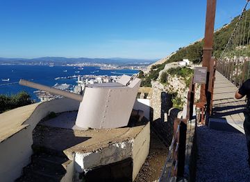
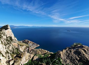
Royal Anglian Way is a scenic 600-meter hiking trail in Gibraltar, offering stunning views and a glimpse into the region's military past. Named after the Royal Anglian Regiment, the path features historical installations and diverse flora and fauna.
Opening times, essentials, and a few local tips gathered into one calmer, easier-to-scan planning section.
Hi, I'm Eve. Here are a few practical things to know before exploring Royal Anglian Way.
Local know-how to help you travel smarter and make the most of every moment.
Walking
If you are within the Upper Rock Nature Reserve, head towards Apes' Den. From there, follow signs for Mediterranean Steps. After approximately 20 minutes, you'll find a fork in the path; take the left path towards Royal Anglian Way. Continue for about 10 minutes to reach the trail. Entrance to the Upper Rock Nature Reserve, which includes access to Royal Anglian Way, costs £13 per adult.
Public Transport
Take a bus to the South District. Transfer to a bus heading towards Europa Point. Get off at the closest bus stop to Royal Anglian Way and walk to the destination. Bus fares are generally affordable. The entrance fee to the Upper Rock Nature Reserve is £13 per adult.
Taxi
From the city center, a taxi to the Upper Rock Nature Reserve entrance will cost approximately £10-£15. From there, follow walking directions to Royal Anglian Way. Remember to factor in the £13 entrance fee to the Upper Rock Nature Reserve.
Use Royal Anglian Way as your starting point for nearby food, family ideas, nightlife, and more local discoveries.

Explore expert travel guides, compare and book tours, experiences, hotels, and more—all from the palm of your hand. Download now for seamless trip planning wherever your wanderlust takes you.

Discover Eastern Beach in Gibraltar – a sun-soaked haven offering golden sands, crystal-clear waters, and thrilling water sports, all with stunning Mediterranean views.
Tell me more about Eastern Beach