

Upper Shillong (Shillong) Travel Guide - Free
Explore Upper Shillong in Shillong with Evendo's free guide. Find the best shops, historic streets, restaurants, and gems on web or mobile.


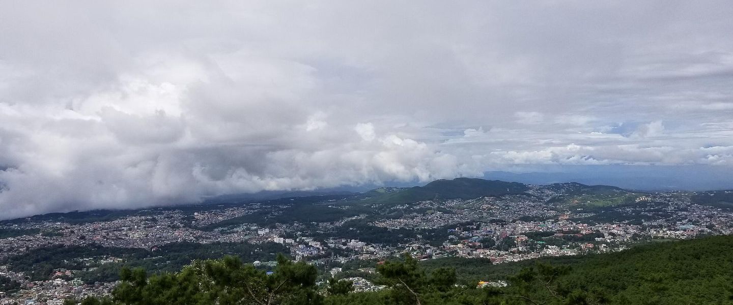


Upper Shillong blends pine forests, cool mountain air, Shillong Peak views and the Air Force Museum with quieter roads above Meghalaya's capital.
Highland Setting and Character
Upper Shillong occupies the elevated southern and western reaches of Shillong, where winding roads climb through pine woodland, military facilities, residential compounds and open viewpoints. The air is cooler than in the lower parts of the city, and the landscape feels more spacious, with long views across forested hills and the surrounding Khasi plateau. It is less a tightly defined historic quarter than a broad upland locality whose identity is shaped by its height, institutional presence and proximity to several of Shillong's best-known viewpoints.Read more about Upper Shillong
Viewpoints, Museums and Forest Roads
Everyday Life on the Plateau
Best attractions in Upper Shillong
Upper Shillong's attractions are primarily scenic and institutional rather than concentrated in a conventional visitor centre. Shillong Peak is the area's defining viewpoint, rising above the city and offering broad panoramas when cloud permits; access is controlled and conditions can change, so visitors should follow local instructions. The Air Force Museum provides an indoor stop with aircraft, uniforms, photographs and displays explaining the Indian Air Force's presence in the northeast. The surrounding pine-covered roads and open ridges offer quieter opportunities to observe Shillong's topography, particularly after rain when the plateau is sharply green. Waterfalls and forest attractions associated with the wider Shillong area may be reached from nearby roads, but should not automatically be treated as part of Upper Shillong. The locality is best explored slowly by taxi, combining one principal sight with roadside views and short, weather-conscious walks rather than expecting a dense sequence of attractions.
-
Tourist attraction
Elephant Falls, Shillong, Meghalaya
Experience the serene beauty and breathtaking landscapes of Elephant Falls in Shillong, a must-visit natural wonder of Meghalaya.
14 min walk · 1.1 km from neighbourhood centre

Best landmarks in Upper Shillong
Shillong Peak is Upper Shillong's most recognisable landmark, both as a physical high point and as a visual reference for understanding how Shillong spreads across ridges and valleys. Its overlook has long been associated with the city's mountain setting, although cloud can conceal the panorama. The Air Force Museum is another defining local landmark, distinguished by its aircraft displays and its connection with the Indian Air Force's presence in the region. Beyond these public sites, the neighbourhood's character is marked by pine-covered slopes, winding access roads, institutional compounds and broad viewpoints rather than a dense collection of historic façades. Some military and government buildings are not public attractions and should be appreciated from permitted public areas only. The contrast between open upland terrain and enclosed official sites reflects Upper Shillong's development as both a scenic edge of the city and an important institutional zone.
-
Nature preserve
Upper Shillong Forest
Explore the serene beauty of Upper Shillong Forest – a nature preserve that offers lush landscapes, diverse wildlife, and peaceful escapes in Meghalaya.
12 min drive · 3.9 km from neighbourhood centre

Explore Upper Shillong on the map
A handpicked selection of must-see spots in Upper Shillong, mapped for you.
Best hotels in Upper Shillong
Upper Shillong essentials
Getting There
Getting Around
Safety
Emergency Situations
Do's and Don'ts
Local Tips

From Eve
Local phrases worth knowing
You don't need to get them perfect. A few words go a long way, and locals appreciate the effort.
Basics
| English | Local | Say it |
|---|---|---|
| Hello | হাই | [hai] |
| Goodbye | বিদায় | [biday] |
| Yes | হাঁ | [ha] |
| No | না | [na] |
| Please/You're welcome | দয়া করে | [doya kore] |
| Thank you | ধন্যবাদ | [dhonyobad] |
| Excuse me/Sorry | দুঃখিত | [dukhit] |
| How are you? | আপুনি কেমন আছন্ন? | [apuni kemon achonno?] |
| Fine. And you? | ঠিক আছি। আপুনি? | [thik ashi. apuni?] |
| Do you speak English? | আপুনি ইংরেজি কথা বলা পারেন? | [apuni ingreji kotha bola paren?] |
| I don't understand | আমি বুঝিনি | [ami bujini] |
Eating & Drinking
| English | Local | Say it |
|---|---|---|
| I'd like to see the menu, please | অনুগ্রহ করে মেনু দেখাবেন | [onugroh kore menu dekhabe] |
| I don't eat meat | আমি মাংস খাই না | [ami mangsho khai na] |
| Cheers! | চিয়ার্স! | [cheers!] |
| I would like to pay, please | অনুগ্রহ করে টাকা দিতে চাই | [onugroh kore taka dite chai] |
Emergencies
| English | Local | Say it |
|---|---|---|
| Help! | সাহায্য! | [sahayyo!] |
| Go away! | চলে যান! | [chole jan!] |
| Call the Police! | পুলিসকে কল করুন! | [policeke kol korun!] |
| Call a doctor! | ডাক্তারকে কল করুন! | [daktarke kol korun!] |
| I'm lost | আমি হারাইয়ে গেছি | [ami haraiye gesi] |
| I'm ill | আমি অসুস্থ | [ami osustho] |
Shopping
| English | Local | Say it |
|---|---|---|
| I'd like to buy... | আমি ... ক্রয় করতে চাই | [ami ... kroy korote chai] |
| I'm just looking | আমি শুধু দেখছি | [ami shudhu dekhchi] |
| How much is it? | এটা কত টাকা? | [eta kot taka?] |
| That's too expensive | এটা খুব বেশি দাম | [eta khub beshi dam] |
| Can you lower the price? | দাম কমাবেন? | [dam komaben?] |
Time & Numbers
| English | Local | Say it |
|---|---|---|
| What time is it? | এখন কতটা বাজে? | [ekhon kotta baje?] |
| It's one o'clock | একটা বাজে | [ekta baje] |
| Half past (10) | দশের অর্ধেক | [dasher ordhek] |
| Morning | সকাল | [shokal] |
| Afternoon | দুপুর | [dupur] |
| Evening | সন্ধ্যা | [shondhya] |
| Yesterday | গতকাল | [gatkal] |
| Today | আজ | [aj] |
| Tomorrow | আগামীকাল | [agamikal] |
| 1 | এক | [ek] |
| 2 | দুই | [dui] |
| 3 | তিন | [tin] |
| 4 | চার | [char] |
| 5 | পাঁচ | [pach] |
| 6 | ছয় | [chhoy] |
| 7 | সাত | [shat] |
| 8 | আট | [at] |
| 9 | নয় | [noy] |
| 10 | দশ | [dash] |
Transport & Directions
| English | Local | Say it |
|---|---|---|
| Where's a/the...? | কোথায় আছে ...? | [kothay achhe ...?] |
| What's the address? | ঠিকানাটা কি? | [thikanata ki?] |
| Can you show me (on the map)? | আপনি আমাকে দেখাতে পারবেন? | [apni amake dekhate parben?] |
| When's the next (bus)? | পরবর্তী (বাস) কবে? | [porborti (bus) kobe?] |
| A ticket (to ....) | একটি টিকেট (প্রায় ....) | [ekti ticket (prae ....)] |
History of Upper Shillong
Khasi Sacred Landscape
Upper Shillong forms part of the wider Khasi highland landscape whose religious and cultural meanings predate the modern city. The name Shillong is traditionally linked with U Shyllong, a protective deity associated with the hills, while Khasi land use historically combined settlements, cultivation, forest and sacred places rather than the formally planned roads of a colonial station. The elevated terrain that later attracted administrators and institutions was therefore already part of a lived cultural landscape. Today, the forested slopes and viewpoints around Upper Shillong are best understood alongside Meghalaya's Khasi heritage, not simply as scenic ground above the city.
The Colonial Hill Station
Shillong developed as a British hill station during the nineteenth century and became the headquarters of the province of Assam in 1874. The cooler plateau encouraged the construction of administrative, residential and institutional areas, while roads gradually connected the higher ground with the growing settlement below. Upper Shillong remained less urbanised than the central core, retaining open slopes and woodland while becoming part of the city's expanding upland infrastructure. The era established the pattern still visible today: a city spread across ridges, with government, military and residential compounds interspersed with pine-covered land.
Military and Institutional Expansion
During the twentieth century, the higher reaches around Shillong acquired a stronger military and institutional presence, reflecting the city's strategic position in northeast India and its role as a regional administrative centre. Facilities associated with the Indian Air Force and other public institutions helped shape the roads, compounds and restricted areas of Upper Shillong. The Air Force Museum, with its displays of aircraft and service history, offers a public-facing interpretation of that continuing association. These developments also reinforced the distinction between Upper Shillong's broad, wooded setting and the denser commercial neighbourhoods lower down.
A Contemporary Upland Locality
After Indian independence, Shillong continued to grow as the capital of Meghalaya, established in 1972, and development spread along its surrounding ridges. Upper Shillong became increasingly residential and institutional while remaining closely associated with Shillong Peak and other highland scenery. Roads, taxis and visitor facilities have made the area accessible for day trips, but its dispersed layout and limited commercial centre remain important parts of its character. Contemporary pressures include traffic, construction and the need to protect slopes and woodland, balancing the demands of a growing capital with the landscape that gives the locality its identity.
Upper Shillong in Photos
Browse through our photo collection highlighting the charm and character of the destination.
Neighbourhoods near Upper Shillong
The closest neighbourhoods to Upper Shillong, if you have time for more than one stop.
-

-

-


Swipe for more neighbourhoods
Explore more
Explore more of Shillong
Shillong, India’s hill city, blends Khasi heritage, pine forests, colonial-era streets, live music, waterfalls and gateways to Meghalaya’s landscapes.
Explore Shillong