From Eve
Know before you go
Hi, I'm Eve. Here are a few practical things to know before exploring سيل الزرقاء جرش.
Local know-how to help you travel smarter and make the most of every moment.

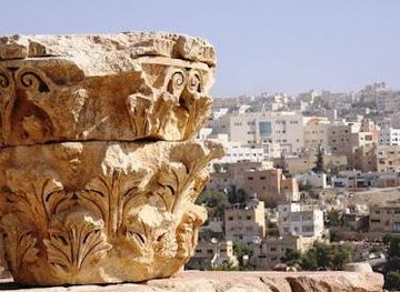
Explore the stunning Blue Stream in Jerash, a perfect hiking area blending nature's beauty with historical significance.
The Blue Stream in Jerash is a breathtaking hiking area that invites tourists to explore its stunning natural beauty and rich historical significance. A paradise for adventure seekers and history enthusiasts alike, this serene location offers unforgettable landscapes, diverse wildlife, and a glimpse into the ancient world.
Opening times, essentials, and a few local tips gathered into one calmer, easier-to-scan planning section.
Hi, I'm Eve. Here are a few practical things to know before exploring سيل الزرقاء جرش.
Local know-how to help you travel smarter and make the most of every moment.
Car
From Ajloun Forest Reserve, head southeast on the main road towards Jerash. Continue for approximately 15 kilometers. As you approach Jerash, look for signs directing you to سيل الزرقاء جرش. Turn left onto the road leading to the location, which is marked by the coordinates 32.2746515, 35.8960765. There may be a small parking area available near the site.
Public Transportation
From Ajloun Forest Reserve, take a taxi or local bus to Jerash. The ride typically takes around 30 minutes. Once in Jerash, you can either walk or take a local taxi to سيل الزرقاء جرش, which is approximately 5 kilometers away from the city center. Ensure to confirm the driver's familiarity with the location or show them the coordinates (32.2746515, 35.8960765) to avoid any confusion.
Walking
If you are already in Jerash and prefer walking, start from the Jerash city center and head towards the سيل الزرقاء جرش, which is about a 1-hour walk. Make your way to the outskirts of Jerash, following the signs towards the hiking area. It is advisable to use a map or GPS for accurate navigation to the coordinates 32.2746515, 35.8960765.
Use Tower Bridge as your starting point for nearby food, family ideas, nightlife, and more local discoveries.

Explore expert travel guides, compare and book tours, experiences, hotels, and more—all from the palm of your hand. Download now for seamless trip planning wherever your wanderlust takes you.
Explore the lush landscapes and rich biodiversity of Ajloun Forest Reserve, a serene sanctuary in northern Jordan perfect for nature enthusiasts and history buffs.
Tell me more about Ajloun Forest Reserve