

Lahug (Cebu City) Travel Guide - Free
Explore Lahug in Cebu City with Evendo's free guide. Find the best shops, historic streets, restaurants, and gems on web or mobile.


Lahug, Cebu City, blends mountain-edge views, Cebuano food, Taoist temples, university life and easy access to the city's northern attractions.
A Foothill Neighbourhood
Lahug occupies a broad, busy stretch of northern Cebu City where urban Cebu begins to climb towards the hills. Its main routes, including Gorordo Avenue, Salinas Drive and Veterans Drive, connect established residential areas with universities, commercial centres and the roads leading towards Busay. The neighbourhood feels more open and elevated than the dense districts closer to the waterfront, although traffic can be considerable along its principal corridors.Read more about Lahug
Temples, Campuses and Everyday Cebu
Food, Shopping and Access
Best attractions in Lahug
Lahug’s strongest attractions combine hillside religious architecture with the everyday life of a university and residential district. Cebu Taoist Temple, within the Beverly Hills subdivision, is the area’s best-known sight, with a ceremonial gate, ornate details, courtyards and elevated views over Cebu City; visitors should follow access and photography rules because it remains a functioning place of worship. Fo Guang Shan Chu Un Temple offers another contemplative stop associated with the neighbourhood’s Buddhist presence. On lower ground, the University of the Philippines Cebu campus provides an institutional and cultural reference point, though it is not a conventional sightseeing complex and access may vary. JY Square and the surrounding streets are more useful for observing local routines, eating and shopping than for formal tourism. The roads towards the uplands also offer glimpses of Cebu’s changing edge, where dense commercial streets give way to greener slopes.
-
Tourist attraction
Beverly Hills Lahug Cebu City
Experience the serene beauty of Beverly Hills Lahug in Cebu City, where lush landscapes meet cultural richness in a perfect getaway.
17 min walk · 1.4 km from neighbourhood centre

Best landmarks in Lahug
Cebu Taoist Temple is Lahug’s most recognisable architectural landmark, occupying a hillside setting within the Beverly Hills subdivision and distinguished by its ornate Chinese-inspired forms, stairways and ceremonial spaces. Its importance is both visual and religious: it represents the long-standing Chinese Filipino community in Cebu while remaining an active temple rather than a museum. Fo Guang Shan Chu Un Temple adds a separate Buddhist landmark to the neighbourhood’s cultural landscape. The University of the Philippines Cebu campus is another significant local reference point, representing Lahug’s role as an educational district and contributing institutional buildings and open campus spaces to the area. JY Square is less historic but functions as a useful contemporary landmark, marking a busy commercial junction. The former Lahug Airport site is historically important to the wider area, although its principal redevelopment lies in neighbouring Apas as Cebu IT Park.
-
Tourist attraction
Beverly Hills Lahug Cebu City
Explore Beverly Hills Lahug in Cebu City: A Scenic Retreat with Cultural Richness and Breathtaking Views.
17 min walk · 1.4 km from neighbourhood centre
-
Apartment building
Lahug cebu city
Explore Lahug, Cebu City – a vibrant neighborhood filled with local culture, stunning views, and delicious food, perfect for your Filipino adventure.
14 min walk · 1.1 km from neighbourhood centre


Explore Lahug on the map
A handpicked selection of must-see spots in Lahug, mapped for you.
Best hotels in Lahug
Best restaurants in Lahug
Lahug’s food scene reflects its position between a long-established residential area, a university campus and the larger commercial districts to the north. Along Gorordo Avenue, Salinas Drive and the streets around JY Square, visitors find casual Filipino restaurants, Cebuano dishes, grilled food, noodle shops, bakeries, cafés and places suited to student budgets. Small eateries and roadside vendors provide a more local rhythm than the polished dining rooms concentrated in nearby Cebu IT Park, although the boundary between the two areas is easy to blur. Cebuano favourites such as grilled meats, rice-based meals and seafood commonly appear alongside Chinese Filipino and international influences, reflecting Cebu City’s broader trading and migration history. Dining is usually informal and practical, with clusters of options rather than one defined restaurant quarter; checking the precise address is sensible when a venue is advertised as being in Lahug.
-
Steak
Acacia Steakhouse
Discover the rich flavors of expertly grilled steaks at Acacia Steakhouse in Cebu City - where every bite is a celebration of culinary excellence.
9 min walk · 0.7 km from neighbourhood centre
-
Restaurant
The Walk
Discover culinary delights at The Walk in Cebu City - where local flavors meet international cuisine in a vibrant urban setting.
12 min walk · 0.9 km from neighbourhood centre
-
Restaurant
AA BBQ
Experience authentic Cebuano barbecue at AA BBQ - where every bite tells a story of flavor and tradition.
9 min walk · 0.7 km from neighbourhood centre
-
Restaurant
Casa Verde
Discover the flavors of Cebu at Casa Verde, where every dish tells a story and every bite is an adventure.
12 min walk · 0.9 km from neighbourhood centre


Best bars in Lahug
Lahug is not primarily a nightclub district, but its student population, cafés and busy commercial roads support a modest evening scene of casual restaurants, coffee shops and bars. The area around JY Square and the lower stretches of Gorordo Avenue is more active after work and school hours, while the uphill residential and temple areas become noticeably quieter. A wider selection of late-night bars, restaurants and entertainment venues is available in neighbouring Apas, particularly Cebu IT Park, which is close but geographically distinct from Lahug. Evening visitors should expect traffic, roadside noise and a mixture of diners, commuters and residents rather than a single concentrated strip. Where nightlife is the main purpose of an outing, confirm the exact location and arrange a reliable ride back, especially for venues beyond the well-lit commercial corridors.
-
French
La Vie Parisienne
Discover the culinary delights of La Vie Parisienne, where French elegance meets Filipino flavors in a charming Cebu setting.
3 min walk · 0.2 km from neighbourhood centre
-
Bar
Verified Rooftop Bar & Lounge
Discover Cebu's nightlife at this breathtaking rooftop bar and lounge, where stunning views and exquisite cocktails create an unforgettable experience.
12 min walk · 0.9 km from neighbourhood centre
-
 Bar
G-SPOT Bar
Discover the exciting nightlife at G-SPOT Bar in Cebu City, where great drinks, lively ambiance, and new friendships await you.
9 min walk · 0.7 km from neighbourhood centre
-
Bar
Ambiance Bar & Restaurant
Discover the vibrant Ambiance Bar & Restaurant in Cebu City, where exquisite Western dishes meet creative cocktails in a lively atmosphere.
13 min walk · 1.1 km from neighbourhood centre


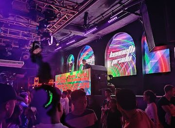
Best nightclubs in Lahug
Lahug is not primarily a nightclub district, but its student population, cafés and busy commercial roads support a modest evening scene of casual restaurants, coffee shops and bars. The area around JY Square and the lower stretches of Gorordo Avenue is more active after work and school hours, while the uphill residential and temple areas become noticeably quieter. A wider selection of late-night bars, restaurants and entertainment venues is available in neighbouring Apas, particularly Cebu IT Park, which is close but geographically distinct from Lahug. Evening visitors should expect traffic, roadside noise and a mixture of diners, commuters and residents rather than a single concentrated strip. Where nightlife is the main purpose of an outing, confirm the exact location and arrange a reliable ride back, especially for venues beyond the well-lit commercial corridors.
-
Bar
Verified Rooftop Bar & Lounge
Experience Cebu City from above at the Verified Rooftop Bar & Lounge, where stunning views and exquisite cocktails create unforgettable memories.
12 min walk · 0.9 km from neighbourhood centre
-
Disco club
Uptown Cebu
Dive into the electrifying nightlife of Uptown Cebu, where great music and a vibrant atmosphere create unforgettable experiences.
19 min walk · 1.5 km from neighbourhood centre
-
Bar
G-SPOT Bar
Experience Cebu City's vibrant nightlife at G-SPOT Bar, featuring an energetic atmosphere, delicious drinks, and a breathtaking rooftop dance floor.
9 min walk · 0.7 km from neighbourhood centre
-
Bar
LAST
Dive into the vibrant nightlife at LAST Bar in Cebu City, where great music and an electric atmosphere await every night.
9 min walk · 0.7 km from neighbourhood centre



Best shops in Lahug
Shopping in Lahug is practical and locally oriented rather than built around a single destination retail street. JY Square Mall serves as the neighbourhood’s most recognisable commercial anchor, with everyday services, groceries, food outlets and small businesses useful to residents, students and visitors. Around Gorordo Avenue, Salinas Drive and the university approaches, independent shops, convenience stores, pharmacies, cafés and informal vendors fill the gaps between larger buildings. The selection changes more quickly and is less tourist-focused than the retail concentration in nearby Cebu IT Park or larger city shopping centres. Visitors are more likely to find daily necessities, snacks, casual clothing and local food than a specialised craft or luxury shopping scene. The neighbourhood’s commercial character is best understood through its mixed-use streets, where shops support ordinary life rather than presenting a curated market experience.
-
Gift shop
K's Gift Shop and More
Explore a unique gift shop in Cebu City offering exquisite souvenirs, event planning, and creative gift wrapping services.
9 min walk · 0.7 km from neighbourhood centre
-
Clothing store
Metrostyle Concept Store
Explore Cebu City's Metrostyle Concept Store for trendy clothing and a unique shopping experience that reflects the latest fashion trends.
7 min walk · 0.6 km from neighbourhood centre
-
Gift shop
Angel Whisper Gifts & Crafts
Explore Cebu's charm through unique crafts and gifts at Angel Whisper Gifts & Crafts, a treasure trove for every traveler.
4 min walk · 0.3 km from neighbourhood centre
-
Wine store
Drop N Shop Specialty Shop
Explore an exquisite selection of wines at Drop N Shop Specialty Shop, a top destination for wine lovers in Cebu City.
15 min walk · 1.2 km from neighbourhood centre


Lahug essentials
Getting There
Getting Around
Safety
Emergency Situations
Do's and Don'ts
Local Tips

From Eve
Local phrases worth knowing
You don't need to get them perfect. A few words go a long way, and locals appreciate the effort.
Basics
| English | Local | Say it |
|---|---|---|
| Hello | Kumusta | [koo-moo-stah] |
| Goodbye | Paalam | [pah-ah-lahm] |
| Yes | Oo | [oh-oh] |
| No | Hindi | [hin-dee] |
| Please/You're welcome | Kumusta | [koo-moo-stah] |
| Thank you | Salamat | [sah-lah-mat] |
| Excuse me/Sorry | Pasensya | [pah-sen-syah] |
| How are you? | Kumusta ka? | [koo-moo-stah kah] |
| Fine. And you? | Mabuti. Ikaw? | [mah-boo-tee. ee-kahw] |
| Do you speak English? | Nakakapagsalita ka ba ng Ingles? | [nah-kah-kah-pahg-sah-lee-tah kah bah ng een-glehs] |
| I don't understand | Hindi ko maintindihan | [hin-dee koh mah-een-teen-dee-hahn] |
Eating & Drinking
| English | Local | Say it |
|---|---|---|
| I'd like to see the menu, please | Gusto ko sanang makita ang menu, pakiusap | [goo-stoh koh sah-nahng mah-kee-tah ahng meh-noo, pah-kee-oo-sahp] |
| I don't eat meat | Hindi ako kumakain ng karne | [hin-dee ah-koh koo-mah-kah-een ng kahr-neh] |
| Cheers! | Mabuhay! | [mah-boo-hai] |
| I would like to pay, please | Gusto ko sanang magbayad, pakiusap | [goo-stoh koh sah-nahng mahg-bah-yahd, pah-kee-oo-sahp] |
Emergencies
| English | Local | Say it |
|---|---|---|
| Help! | Tulong! | [too-long] |
| Go away! | Lumayas ka! | [loo-mah-yahs kah] |
| Call the Police! | Tumawag ka ng pulis! | [too-mah-wahg kah ng poo-lees] |
| Call a doctor! | Tawag ka ng doktor! | [tah-wahg kah ng dohk-tohr] |
| I'm lost | Nawawala ako | [nah-wah-wah-lah ah-koh] |
| I'm ill | Sakit ako | [sah-keet ah-koh] |
Shopping
| English | Local | Say it |
|---|---|---|
| I'd like to buy... | Gusto ko bumili ng... | [goo-stoh koh boo-mee-lee ng] |
| I'm just looking | Nagmamasid lang ako | [nahg-mah-mah-seed lahng ah-koh] |
| How much is it? | Magkano ito? | [mahg-kah-noh ee-toh] |
| That's too expensive | Masyadong mahal | [mah-syah-dohng mah-hahl] |
| Can you lower the price? | Pwede mo bang babaan ang presyo? | [pweh-deh moh bahng bah-bah-ahn ahng preh-syo] |
Time & Numbers
| English | Local | Say it |
|---|---|---|
| What time is it? | Anong oras na? | [ah-nawng oh-rahs nah] |
| It's one o'clock | Alas-uno na | [ah-lahs-oo-noh nah] |
| Half past (10) | Alas-diyes y medya | [ah-lahs-dyehs ee med-yah] |
| Morning | Umaga | [oo-mah-gah] |
| Afternoon | Hapon | [hah-pohn] |
| Evening | Gabi | [gah-bee] |
| Yesterday | Kahapon | [kah-hah-pon] |
| Today | Ngayon | [ngah-yohn] |
| Tomorrow | Bukas | [boo-kahs] |
| 1 | Isa | [ee-sah] |
| 2 | Dalawa | [dah-lah-wah] |
| 3 | Tatlo | [taht-loh] |
| 4 | Apat | [ah-paht] |
| 5 | Lima | [lee-mah] |
| 6 | Anim | [ah-neem] |
| 7 | Pito | [pee-toh] |
| 8 | Walo | [wah-loh] |
| 9 | Siyam | [see-yahm] |
| 10 | Sampu | [sahm-poo] |
Transport & Directions
| English | Local | Say it |
|---|---|---|
| Where's a/the...? | Nasaan ang...? | [nah-sah-ahn ahng] |
| What's the address? | Ano ang address? | [ah-noh ahng ah-drehs] |
| Can you show me (on the map)? | Pwede mo ba akong ipakita (sa mapa)? | [pweh-deh moh bah ah-kohng ee-pah-kee-tah sah mah-pah] |
| When's the next (bus)? | Kailan ang susunod (bus)? | [kahy-lahn ahng soo-soo-nod] |
| A ticket (to ....) | Isang ticket (papuntang ....) | [ee-sahng tee-keht pah-poon-tahng] |
History of Lahug
A Foothill Area Beyond Old Cebu
Lahug developed inland from Cebu’s older commercial core, in a landscape of foothills, streams and agricultural land that connected the city with the upland settlements towards Busay. Its position made it a transition zone rather than a traditional port-side district: roads running north and uphill gradually brought homes, institutions and businesses into the area. The name Lahug is closely associated with the locality and its waterways, although explanations of its precise linguistic origin vary. The neighbourhood’s later identity was shaped less by a single founding event than by Cebu City’s steady expansion beyond its historic centre.
Schools and Roads Shape Lahug
During the American period and the decades that followed, improved roads and public institutions encouraged Cebu City’s growth into the northern foothills. The University of the Philippines Cebu traces its local institutional history to the establishment of Cebu Junior College in 1918 and became an important presence in Lahug as higher education expanded. Schools, churches and residential subdivisions altered the area’s land use, while routes such as Gorordo Avenue and Salinas Drive tied Lahug more closely to the city’s central districts. This combination of education, transport and housing gave the neighbourhood a mixed character that remains visible today.
The Lahug Airport Landscape
For much of the twentieth century, Lahug was associated with Cebu’s former airport, whose airfield occupied land in the northern part of the city. Commercial aviation later moved to Mactan, and the airport site was redeveloped rather than retained as an airfield. The transformation changed the surrounding urban geography, bringing large-scale offices, retail and new roads to the area now identified with Cebu IT Park in neighbouring Apas. Lahug itself remained a separate, established barangay, but the redevelopment increased traffic, land values and commercial activity along its approaches.
Hillside Communities and Contemporary Change
The hillside parts of Lahug became associated with residential subdivisions and religious institutions, including Cebu Taoist Temple, established in 1972 by Cebu’s Chinese Filipino community. These temples added a prominent cultural and architectural layer to a neighbourhood already shaped by education and suburban growth. In recent decades, apartment construction, cafés, offices and service businesses have joined older homes and local shops. The result is a layered urban district: institutional and residential in its core, commercially connected to Apas and Cebu IT Park, and still marked by the wooded slopes and roads rising towards Busay.
Lahug in Photos
Browse through our photo collection highlighting the charm and character of the destination.
Neighbourhoods near Lahug
The closest neighbourhoods to Lahug, if you have time for more than one stop.
-

-


Swipe for more neighbourhoods
Explore more

Explore more of Cebu City
Cebu City combines Spanish-era landmarks, lively markets, island cuisine and access to the Philippines’ historic Visayan heartland and coastal adventures.
Explore Cebu City