Ben Lomond
Scotland’s most southerly Munro, rising above Loch Lomond with panoramic Highland views and a challenging yet rewarding hike to the summit.
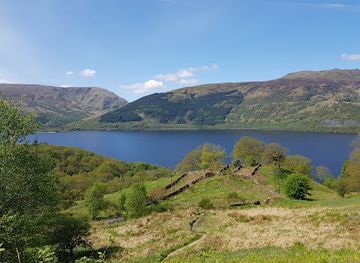
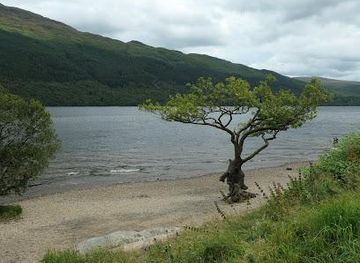
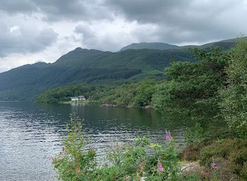
A Highland Beacon Above Loch Lomond
Ben Lomond, standing at 974 metres (3,196 feet), is Scotland’s most southerly Munro and one of its most iconic mountains. It rises prominently from the eastern shore of Loch Lomond, forming a dramatic backdrop to the loch’s shimmering waters and scattered islands. The name Ben Lomond is thought to derive from Gaelic, meaning something like “beacon mountain” or “beetle-shaped mountain,” and for centuries it has served as a landmark for travelers and locals alike. From viewpoints around Luss or Ross Priory, the mountain appears almost like a shark’s fin, while from Inverbeg and beyond it takes on a more rounded, imposing profile.The Hike to the Summit
The most popular route begins at the Rowardennan car park, where a clear, well-constructed path winds through ancient oak and birch woodland before emerging onto open moorland. The first section is relatively gentle, passing through managed forest where native trees are gradually reclaiming former plantations. After a couple of gates and a forestry track, the path begins to climb more steeply, with stone-pitched zigzags helping to ease the ascent. At Sron Aonaich, the “nose of the ridge,” the gradient eases and the full scale of the mountain unfolds ahead. The final push to the summit ridge is steep in places, but the path remains clear and well-defined, making it accessible to walkers of reasonable fitness.Views and the Summit Experience
Reaching the summit ridge rewards hikers with one of the finest panoramas in southern Scotland. On a clear day, the view stretches the entire length of Loch Lomond, with its maze of islands and the Luss Hills on the western shore. To the north, the Trossachs and the Arrochar Alps unfold, with peaks like The Cobbler, Ben Vorlich, and Ben Ledi standing out. Further north, the distant bulk of Ben Nevis can often be seen, while to the west the islands of Arran, Bute, and the Kyles of Bute are visible. The summit area is broad enough to allow space for rest and reflection, with cairns and the trig point marking the highest point. The contrast between the loch’s calm waters below and the wild, open moorland above is striking.History, Folklore and the Mountain’s Character
Ben Lomond has long held a place in Scottish history and legend. It is said to have been the lair of a fearsome dragon in local folklore, while other tales speak of a powerful giant buried within its slopes. The mountain’s strategic position overlooking the loch made it an important landmark in times of conflict, and its slopes have seen centuries of shepherding, hunting, and forestry. Today, it is managed in part by the National Trust for Scotland and forms a key part of Loch Lomond and The Trossachs National Park. The mountain’s character changes with the weather: on sunny days it feels accessible and inviting, but in mist or wind it quickly becomes a serious mountain environment.Practicalities and the Mountain Environment
The standard route from Rowardennan is around 13 km (8 miles) round trip with about 930 metres of ascent, typically taking between 4 and 6 hours depending on pace and conditions. The path is generally good underfoot, but there are rocky sections and exposed areas, especially on the upper slopes and ridge. Weather can change rapidly, and conditions at the summit are often much colder and windier than at the base. Hikers should carry full hillwalking gear, including waterproofs, warm layers, food, water, and a map and compass (or GPS), even on seemingly benign days. The mountain is popular year-round, with peak numbers in summer, and the car park at Rowardennan can fill early on fine weekends.Wildlife and the Surrounding Landscape
The lower slopes of Ben Lomond support a mix of woodland and moorland habitats, home to red deer, roe deer, and a variety of birds including black grouse, ptarmigan, and raptors such as buzzards and peregrine falcons. Pine martens and other smaller mammals also inhabit the area, though they are more elusive. The surrounding national park includes ancient woodlands, lochs, and glens, offering a rich tapestry of landscapes for exploration. The mountain’s position at the edge of the Highlands makes it a perfect introduction to Munro-bagging, combining accessibility with a genuine sense of wilderness and grandeur.Local tips
- Start early, especially in summer, to avoid crowds and secure a parking spot at Rowardennan; the car park fills quickly on fine weekends.
- Pack full hillwalking gear: waterproofs, warm layers, hat, gloves, sturdy boots, food, water, and a map/compass or GPS, even on sunny days.
- Check the weather forecast before setting out and be prepared for rapid changes; conditions at the summit are often much colder and windier than at the base.
- Stick to the main path unless experienced; the Ptarmigan Ridge route is steeper and more exposed, suitable only for confident hillwalkers.
- Keep dogs under control, especially around sheep and cattle on the lower slopes, and always clean up after them to respect the environment.
A brief summary to Ben Lomond
- Stirling, GB
Getting There
-
By car
Drive from Glasgow or the central belt via the A811 and B829 through Queen Elizabeth Forest Park to the Rowardennan car park on the east shore of Loch Lomond. The journey takes about 45–60 minutes from Glasgow, depending on traffic. Parking is limited and fills quickly on fine weekends; there is a small charge to park.
-
By public transport and ferry
Take a train or bus to Balloch or Tarbet on the southern end of Loch Lomond, then use a seasonal ferry service across the loch to Rowardennan. From there, the Ben Lomond path starts a short walk from the jetty. Ferry schedules are seasonal and infrequent, so check timetables in advance.
-
By bike
Cycle along the West Highland Way from Balloch or other points around Loch Lomond to Rowardennan; the ride from Balloch takes about 2–3 hours on a road or hybrid bike. The Ben Lomond Hill Path is also used by mountain bikers, but it is shared with walkers and can be busy, especially in summer.
-
On foot
Walk the West Highland Way from Balloch or other points along Loch Lomond’s eastern shore to Rowardennan; the section from Balloch to Rowardennan is around 15–18 km and takes 4–6 hours, depending on pace and conditions.