From Eve
Know before you go
Hi, I'm Eve. Here are a few practical things to know before exploring DeSoto Falls.
Local know-how to help you travel smarter and make the most of every moment.

Discover the beauty of DeSoto Falls, one of Alabama's tallest waterfalls, offering hiking, history, and stunning views.
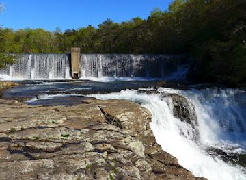
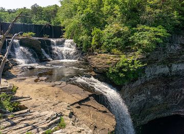
DeSoto Falls, one of Alabama's tallest and most visited waterfalls, plunges 104 feet into a canyon carved by its own force. Named after Spanish explorer Hernando de Soto, the falls offer scenic views, hiking trails, and a glimpse into Alabama's natural beauty and history.
Opening times, essentials, and a few local tips gathered into one calmer, easier-to-scan planning section.
Hi, I'm Eve. Here are a few practical things to know before exploring DeSoto Falls.
Local know-how to help you travel smarter and make the most of every moment.
Driving
From Mentone, Alabama, follow County Road 89 (Scenic Highway) south for 2.2 miles to Tutwiler Gap. Turn left onto County Road 613 (DeSoto Falls Road) and continue for 0.6 miles. The DeSoto Falls Picnic Area will be on your right. Note that parking is limited, especially on weekends. A parking fee of $4 per vehicle is required.
Walking
From Lazy River Cottage, walk a short distance on County Road 613 (DeSoto Falls Road) to the parking area at the DeSoto Falls Trailhead. Follow the well-marked trails to reach the falls overlook or the basin below. Be prepared for moderate inclines and rocky terrain.
Use Tower Bridge as your starting point for nearby food, family ideas, nightlife, and more local discoveries.

Explore expert travel guides, compare and book tours, experiences, hotels, and more—all from the palm of your hand. Download now for seamless trip planning wherever your wanderlust takes you.
Explore the Tennessee Valley in Alabama: A blend of natural beauty, rich history, and vibrant culture, perfect for outdoor adventures and cultural immersion.
Tell me more about Tennessee Valley