

Hautes Fagnes Travel Guide - Free Web & App
Your ultimate guide to Hautes Fagnes. Discover top landmarks, proposed trips, and local tips. Free on the web or via the Evendo companion app.


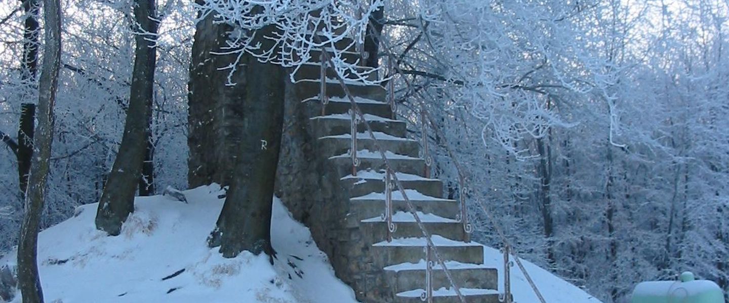


Hautes Fagnes in Belgium offers peat bogs, heathland, Signal de Botrange, winter walks, wildlife and quiet trails near Malmedy and Eupen.
Landscape and Natural Character
Hautes Fagnes, or the High Fens, is a vast upland landscape in eastern Belgium, close to the German border and stretching across the provinces of Liège and the German-speaking East Cantons. Its open plateau is shaped by peat bogs, wet heath, tussock grass, shallow valleys and dark spruce plantations, with wide skies and few substantial settlements inside the protected area. Signal de Botrange, at 694 metres, is Belgium’s highest point and an important reference for exploring the surrounding reserve. Wooden boardwalks and marked paths lead visitors through fragile wetland habitats, while lower valleys contain streams, woodland and reservoirs.Read more about Hautes Fagnes
History and Protected Landscapes
Exploring the High Fens
When is the best time to visit Hautes Fagnes?
Best: June–August · 20–22°C| Month | High (°C) | Rainfall (mm) |
|---|---|---|
| January | 6 | 91 |
| February | 6 | 80 |
| March | 10 | 70 |
| April | 13 | 60 |
| May | 17 | 70 |
| June (best) | 20 | 81 |
| July (best) | 22 | 91 |
| August (best) | 22 | 91 |
| September | 18 | 81 |
| October | 14 | 71 |
| November | 9 | 80 |
| December | 7 | 90 |
Getting to and around Hautes Fagnes
How to get there
Transportation
Best attractions in Hautes Fagnes
The central attraction of Hautes Fagnes is the open peatland plateau, where wooden paths and boardwalks cross wet heath, bog pools and grass-covered expanses shaped by centuries of water and weather. Signal de Botrange is the highest point in Belgium and provides a natural orientation point, while nearby Mont Rigi and Baraque Michel offer access to marked walks and broad upland scenery. The Maison du Parc-Botrange helps visitors understand the reserve’s ecology and landscape management. Around the margins, the valleys of the Hill, Warche and other streams lead towards wooded slopes, reservoirs and villages, with Robertville and its lake providing a contrasting, more enclosed setting. The eastern side near Eupen includes forested approaches and links towards the Hertogenwald, while the western approaches around Malmedy and Waimes combine plateau walks with rural scenery. Attractions are widely dispersed, and the most rewarding visits usually concentrate on one section rather than attempting to cover the whole area in a single outing.
-
Tourist attraction
High Fens-Eifel Nature Park
Discover the breathtaking beauty of High Fens-Eifel Nature Park, a paradise for nature lovers and outdoor enthusiasts in Belgium.
-
Tourist attraction
Lake Gileppe
Explore the scenic beauty of Lake Gileppe, a stunning destination for outdoor activities and relaxation in the heart of Belgium's Ardennes.
-
Tourist attraction
Promenade de la Hoëgne / La Hoëgne Valley
Explore the breathtaking landscapes of Hoëgne Valley in Belgium, where nature, tranquility, and adventure await every traveler.
-
Tourist attraction
Cascade du Bayehon
Experience the stunning beauty of Cascade du Bayehon, a natural wonder in the heart of the Ardennes, perfect for nature lovers and adventure seekers alike.


Best landmarks in Hautes Fagnes
Signal de Botrange is the defining physical landmark of Hautes Fagnes and the highest point in Belgium, standing on the open plateau amid peatland, heath and weather-exposed grass. Baraque Michel and Mont Rigi are historic highland reference points and established access areas, while the wooden tracks through the reserve reveal the ecological importance of bogs that are easily damaged by trampling. The plateau’s streams and wet valleys descend towards wooded landscapes and reservoirs, including the lake at Robertville on the western side of the wider High Fens area. Around the margins, the German-speaking town of Eupen and the Walloon town of Malmedy represent the region’s distinctive borderland culture, although they are gateways rather than landmarks within the core reserve. These natural and human features together explain why Hautes Fagnes is perceived not as a single viewpoint but as a broad upland system of peat, water, forest and historic routes.
-
National park
High Fens-Eifel Nature Park
Explore the enchanting landscapes and diverse wildlife of High Fens-Eifel Nature Park, Belgium's stunning national park offering year-round adventures.
-
Tourist attraction
Lake Gileppe
Discover the natural beauty of Lake Gileppe, Belgium - a serene retreat for hiking, kayaking, and enjoying stunning landscapes.
-
Castle
Castle of Reinhardstein
Explore the captivating Castle of Reinhardstein in Waimes, a blend of medieval history, breathtaking landscapes, and vibrant cultural experiences.
-
Nature preserve
Cascade du Bayehon
Explore the stunning Cascade du Bayehon, a captivating nature preserve and waterfall in the heart of the Belgian Ardennes, perfect for outdoor enthusiasts.


Explore Hautes Fagnes on the map
Plan your trip on one map. See where the top attractions, landmarks, restaurants and hotels are, and book hotels and experiences in a few clicks.
Best hotels in Hautes Fagnes
Best restaurants in Hautes Fagnes
Dining in and around Hautes Fagnes is concentrated in gateway towns and villages rather than spread across the protected plateau. Malmedy, Waimes, Eupen, Robertville and nearby settlements offer cafés, restaurants, bakeries, traditional inns and village establishments, with more choice than the isolated roadside locations at the heart of the reserve. Regional cooking reflects the borderland character of eastern Belgium, combining Walloon and German-speaking influences with hearty soups, potatoes, local meats, farmhouse cheeses and seasonal produce. Ardennes specialities, including cured meats and game when in season, may appear alongside Belgian beer and pastries. Trout from the wider Ardennes region is also associated with local menus, although availability varies. Hikers should not assume that a café or restaurant will be open beside every trailhead, so provisions from a gateway town can be useful for longer walks.
-
Brewpub
Belgium Peak Beer
Discover authentic Belgian brews and delightful cuisine at Belgium Peak Beer, nestled in the stunning Hautes Fagnes region.
-
Belgian
La Baraque Michel
Experience authentic Belgian cuisine amidst breathtaking views at La Baraque Michel – where culinary delights meet nature's beauty.
-
 Restaurant
Le Domaine Des Hautes Fagnes
Experience exceptional dining and wellness at Le Domaine Des Hautes Fagnes – your perfect getaway in Belgium's stunning natural landscape.
-
Brasserie
Le Mont Rigi
Experience exquisite dining and breathtaking views at Le Mont Rigi – your perfect retreat in Waimes amidst nature's beauty.


Best bars in Hautes Fagnes
Hautes Fagnes is a quiet rural destination rather than a nightlife centre. Evening life is found mainly in the traditional cafés, hotel bars, brasseries and village pubs of Malmedy, Waimes, Eupen, Robertville and the surrounding settlements, where local beer and conversation are more characteristic than late-night clubs. Malmedy and Eupen provide the broadest choice of places to eat and linger, while smaller villages may have only a limited number of hospitality venues. Seasonal festivals, local cultural programmes and events in gateway towns can add evening activity, but their timing changes from year to year. On the plateau itself, darkness arrives quickly and commercial entertainment is sparse, making the open landscape more suited to quiet accommodation, stargazing where conditions permit and early starts for walking.
-
Brewpub
Belgium Peak Beer
Discover the charm of Belgium Peak Beer in Waimes — where craft brews and traditional cuisine meet in a cozy brewpub atmosphere.
-
Belgian
La Baraque Michel
Discover the essence of Belgian gastronomy at La Baraque Michel, a charming restaurant in Jalhay offering a taste of tradition and local flavors.
-
Brasserie
Le Mont Rigi
Experience culinary delights and scenic beauty at Le Mont Rigi, a charming brasserie and hotel in Waimes, Belgium, perfect for travelers seeking relaxation.
-
Belgian
Le petit Mont Rigi
Experience the essence of Belgium at Le Petit Mont Rigi with exquisite local cuisine and stunning views in Waimes.


Best nightclubs in Hautes Fagnes
Hautes Fagnes is a quiet rural destination rather than a nightlife centre. Evening life is found mainly in the traditional cafés, hotel bars, brasseries and village pubs of Malmedy, Waimes, Eupen, Robertville and the surrounding settlements, where local beer and conversation are more characteristic than late-night clubs. Malmedy and Eupen provide the broadest choice of places to eat and linger, while smaller villages may have only a limited number of hospitality venues. Seasonal festivals, local cultural programmes and events in gateway towns can add evening activity, but their timing changes from year to year. On the plateau itself, darkness arrives quickly and commercial entertainment is sparse, making the open landscape more suited to quiet accommodation, stargazing where conditions permit and early starts for walking.
-
Brewpub
Belgium Peak Beer
Experience the authentic taste of Belgium at Peak Beer Brewpub, where craft brews and local flavors come together in the heart of Waimes.
-
Ski resort
Club de Ski Alpin d'Ovifat
Discover thrilling winter sports and breathtaking mountain views at the Club de Ski Alpin d'Ovifat, a premier ski resort in Belgium.
-
European
Bar à Bout des Charmilles
Discover the flavors of Europe at Bar à Bout des Charmilles, a cozy restaurant in Waimes surrounded by breathtaking nature.
-
Function room facility
Barassocies
Experience elegance and charm at Barassocies, a premier venue in Waimes for unforgettable gatherings and events amidst the beauty of the Ardennes.


Best shops in Hautes Fagnes
Shopping within Hautes Fagnes is limited and practical, with most options located in gateway towns rather than on the open plateau. Malmedy and Eupen have the widest selection of independent shops, bakeries, food retailers and everyday services, while Waimes, Robertville and smaller villages provide more modest local shopping. Visitors may find regional cheeses, Ardennes cured meats, preserves, honey, chocolate, beer and other food products associated with eastern Belgium, together with crafts, artwork and locally themed gifts in some visitor-oriented businesses. Outdoor equipment and walking supplies are more readily available in larger towns than near remote trailheads. Farm shops and small producers may operate on the edges of the destination, but opening arrangements vary, so shopping should not be left until after a long walk. The character of the area is rural and food-led rather than centred on a concentrated retail district or permanent craft market.
-
Gift shop
Le Domaine Des Hautes Fagnes
Discover the beauty of nature and relaxation at Le Domaine Des Hautes Fagnes, your ultimate retreat in Waimes, Belgium.
-
Tourist information center
La Maison du Parc-Botrange
Explore the natural beauty of Hautes Fagnes at La Maison du Parc-Botrange, Belgium's highest visitor center with stunning views and rich biodiversity.
-
Gas station
TotalEnergies
Discover convenience at TotalEnergies in Waimes, where quality fuel meets fresh coffee and delicious sandwiches for every traveler.
-
Bicycle store
Burkardt Srl.
Discover Burkardt Srl. in Waimes: Your ultimate destination for bicycles, fitness gear, and wellness products amidst Belgium's stunning landscapes.


Get your free copy of our complete guide to Hautes Fagnes, delivered straight to you.
Everything on this page, from attractions and restaurants to essentials and local phrases, in one PDF you can read offline, print or share.
Already have an account? Sign in
Your Hautes Fagnes guide is ready.
We'll send it to · Not you? Sign out

Getting your guide ready…
We are putting together a fresh copy of the Hautes Fagnes guide. This can take up to a minute.
This can take a few moments. If your browser asks, choose Allow so the download can start. You'll find the guide in your Downloads folder.
Nothing happened? Download it again
Sorry, the guide is taking longer than usual. Please try again in a minute, or get it by email instead.
Hautes Fagnes essentials
Currency and Payment
Safety
Emergency Situations
Do's and Don'ts
Local Tips
From Eve
Local phrases worth knowing
You don't need to get them perfect. A few words go a long way, and locals appreciate the effort.
Basics
| English | Local | Say it |
|---|---|---|
| Hello | Salut | [sah-LOO] |
| Goodbye | Au revoir | [oh reh-VWAH] |
| Yes | Oui | [WEE] |
| No | Non | [noh] |
| Please/You're welcome | S'il vous plaît/De rien | [seel voo pleh/duh ree-AHN] |
| Thank you | Merci | [mehr-SEE] |
| Excuse me/Sorry | Excusez-moi/Désolé | [ehk-SKEW-zay mwah/deh-zoh-LAY] |
| How are you? | Comment ça va? | [kohm-ahn sah vah] |
| Fine. And you? | Bien. Et toi? | [byen/et twah] |
| Do you speak English? | Parlez-vous anglais? | [par-lay voo ahn-GLAY] |
| I don't understand | Je ne comprends pas | [zhuh nuh kohm-prahn pah] |
Eating & Drinking
| English | Local | Say it |
|---|---|---|
| I'd like to see the menu, please | Je voudrais voir la carte, s'il vous plaît | [zhuh voo-dray vwahr lah kart, seel voo pleh] |
| I don't eat meat | Je ne mange pas de viande | [zhuh nuh mahnj pah duh vyand] |
| Cheers! | Santé! | [sahn-TAY] |
| I would like to pay, please | Je voudrais payer, s'il vous plaît | [zhuh voo-dray peh-yay, seel voo pleh] |
Emergencies
| English | Local | Say it |
|---|---|---|
| Help! | Au secours! | [oh seh-KOOR] |
| Go away! | Allez-vous en! | [ah-lay vooz ahn] |
| Call the Police! | Appelez la police! | [ah-pleh lah poh-LEES] |
| Call a doctor! | Appelez un médecin! | [ah-pleh uh may-deh-SAN] |
| I'm lost | Je suis perdu | [zhuh swee pair-doo] |
| I'm ill | Je suis malade | [zhuh swee mah-LAHD] |
Shopping
| English | Local | Say it |
|---|---|---|
| I'd like to buy... | Je voudrais acheter... | [zhuh voo-dray ah-shet-ay] |
| I'm just looking | Je regarde juste | [zhuh ruh-gard zhoost] |
| How much is it? | Combien ça coûte? | [kohm-byen sah koot] |
| That's too expensive | C'est trop cher | [say troh shair] |
| Can you lower the price? | Pouvez-vous baisser le prix? | [poo-veh voo beh-say luh pree] |
Time & Numbers
| English | Local | Say it |
|---|---|---|
| What time is it? | Quelle heure est-il? | [kehl uhr ay eel] |
| It's one o'clock | Il est une heure | [eel ayz uhn uhr] |
| Half past (10) | Dix heures et demie | [dees uhr ay duh-MEE] |
| Morning | Matin | [ma-TAN] |
| Afternoon | Après-midi | [ah-PRAY mee-DEE] |
| Evening | Soir | [swahr] |
| Yesterday | Hier | [ee-AIR] |
| Today | Aujourd'hui | [oh-zhoor-DWEE] |
| Tomorrow | Demain | [duh-MAN] |
| 1 | Un | [uhn] |
| 2 | Deux | [duh] |
| 3 | Trois | [twah] |
| 4 | Quatre | [kat] |
| 5 | Cinq | [sank] |
| 6 | Six | [sees] |
| 7 | Sept | [sett] |
| 8 | Huit | [weet] |
| 9 | Neuf | [nuff] |
| 10 | Dix | [dees] |
Transport & Directions
| English | Local | Say it |
|---|---|---|
| Where's a/the...? | Où est...? | [oo eh...] |
| What's the address? | Quelle est l'adresse? | [kehl eh la-dress] |
| Can you show me (on the map)? | Pouvez-vous me montrer (sur la carte)? | [poo-veh voo muh mohn-tray (soor lah kart)] |
| When's the next (bus)? | Quand est le prochain (bus)? | [kahn eh luh proh-shahn (boos)] |
| A ticket (to ....) | Un billet (pour ...) | [uhn bee-YAY (poor)] |
History of Hautes Fagnes
A Peat-Built Upland
The High Fens plateau developed through a combination of cool, wet conditions, poor drainage and relatively impermeable ground, allowing peat to accumulate over long periods. These peatlands are not simply open moorland: they are waterlogged ecosystems created by the gradual preservation of plant material. The plateau’s streams, wet hollows and raised bogs helped shape the wider geography of eastern Belgium, while exposed conditions limited intensive agriculture in the highest areas. Geological and climatic processes therefore provide the foundation for the landscape that later communities used for grazing, peat extraction and forestry.
Early Use and Rural Communities
Human activity around the High Fens developed mainly along its margins and in more sheltered valleys, where farming, pastoral use and forestry were more practical than on the wettest plateau. Communities in the surrounding region included French-speaking and German-speaking populations, and local identity was influenced by the changing political geography of eastern Belgium. Paths and routes across the upland connected settlements and provided access for livestock, timber and other resources. The harsh climate, sparse settlement and difficult terrain helped preserve the impression of a remote landscape even as surrounding villages developed.
Peat, Forestry and Water Management
Peat was traditionally cut in parts of the High Fens for domestic fuel, leaving traces of earlier land use in some wetland areas. Forestry also became important, particularly through the spread of spruce plantations on ground considered suitable for tree growth. Ditches and other drainage works changed the movement of water across sections of the plateau, affecting peat formation and wetland habitats. These interventions connected the landscape to the economic needs of nearby communities, but they also contributed to the environmental pressures that later conservation programmes sought to address.
Borders, Roads and Strategic Terrain
The High Fens occupy a borderland between Belgium and Germany, and this position has influenced administration, travel and regional identity over several centuries. Roads crossing or approaching the plateau linked communities on either side of the frontier, while the exposed terrain gave the area strategic importance during periods of conflict. The Second World War affected the wider eastern Belgian region, although the reserve is more closely associated today with its border geography, upland routes and cultural connections between the Liège province and the German-speaking communities nearby.
From Protection to Restoration
Growing awareness of the ecological value of the plateau led to formal protection and the development of the Hautes Fagnes nature reserve in the twentieth century. Conservation work has focused on maintaining wet heath and peatland, restoring natural water levels, managing trees and limiting pressure on sensitive habitats. Visitor access is directed towards marked routes and boardwalks so that people can experience the landscape without spreading damage across the bogs. Contemporary Hautes Fagnes is therefore both a recreational destination and a managed conservation landscape, where restoration continues to respond to drainage, invasive vegetation, drought and fire risk.
Hautes Fagnes in Photos
Browse through our photo collection highlighting the charm and character of the destination.
Neighbouring destination travel guides
The closest destinations to Hautes Fagnes, if you have time for more than one.
-

-

-

-

-


Swipe for more destinations
Explore more

Explore more of Duchy of Limburg
Explore the Duchy of Limburg: A picturesque region in Belgium offering a blend of history, culture, and nature. Perfect for a peaceful retreat and diverse adventures.
Explore Duchy of Limburg
Explore more of Belgium
Discover Belgium: A blend of medieval charm, culinary delights, and stunning landscapes. Explore historic cities, savor exquisite chocolates, and enjoy a perfect getaway.
Explore Belgium