Background

Kløverstien in Skørping

Four colour‑coded trails fanning out from Kulturstationen, linking Skørping’s streets, forest edges and village landscapes into easy, everyday nature adventures.

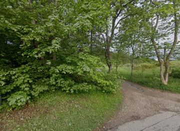
Kløverstien in Skørping is a network of four way‑marked walking routes that loop out from Kulturstationen into the forests, heathland and residential edges of this small North Jutland railway town. Designed so you can mix everyday exercise with genuine nature time, the green, blue, red and black routes range from short family‑friendly laps to longer excursions skirting Rold Forest and the old village of Gl. Skørping. Clear clover symbols and information boards make it easy to follow, while the varied terrain offers both gentle pavement stretches and softer woodland paths.

Plan your visit

A brief summary to Kløverstien I Skørping

Opening times, essentials, and a few local tips gathered into one calmer, easier-to-scan planning section.

Plan your visit

📍
Skørping, DK
🕒
Duration: 1 to 4 hours
💷
Free
🏛
Outdoor
📶
Mobile reception: 4 out of 5

Explore places near Kløverstien I Skørping

    See all →

    Unlock the Best of Kløverstien I Skørping

    Find tickets, tours with entry, and experiences available for this location.

    Buy tickets

    No tickets available

    Book tours with entry

    No tours with entry available

    Book tours without entry

    No tours without entry available

    Getting There

    Train from Aalborg

    From Aalborg, take a regional train on the Randers–Aalborg line to Skørping Station; the journey typically takes 25–35 minutes with departures around twice per hour in daytime and costs roughly 60–90 DKK one way in standard class. From the station it is a short, level walk of several minutes to Kulturstationen, making this the most convenient public‑transport option year‑round.

    Train from Aarhus

    From Aarhus, board an intercity or regional train towards Aalborg and get off at Skørping; travel time is usually 1 hour 10 minutes to 1 hour 30 minutes, with prices commonly in the range of 120–200 DKK one way depending on departure and ticket type. Trains are frequent during the day, but some evening services are less regular, so check the timetable in advance.

    Car within Rebild Municipality

    Driving from nearby towns in Rebild Municipality, such as Støvring or Rebild, typically takes 10–20 minutes on paved main roads. Parking is generally available near Kulturstationen and around the station area without special permits, but spaces can be busier on weekday mornings. This option offers flexibility if you plan to combine the clover paths with visits deeper into Rold Forest or Rebild Bakker the same day.

    Cycling from surrounding villages

    From smaller villages in the Skørping area, you can reach Kulturstationen by bicycle in about 20–45 minutes using local roads and signposted cycle routes. Terrain is gently rolling, with some mild climbs but no steep hills, and conditions are suitable for most city or touring bikes in snow‑free seasons. This is a low‑cost, flexible option and pairs naturally with continuing on the clover routes by bike.

    For the on-the-go comforts that matter to you

    Restrooms
    Drink Options
    Drinking Water
    Food Options
    Seating Areas
    Trash Bins
    Information Boards
    Visitor Center

    Local tips

    Start at Kulturstationen to see the main map board and choose your route length before setting off; take a photo of the map for quick reference on the trail.
    Wear waterproof shoes outside summer, as forest and field‑edge sections on the red and black routes can stay muddy after rain.
    If you want a relaxed stroll, pick the green or blue routes; choose the red or black loops for a more substantial hike or longer run.
    Bring water and a light snack; there are benches and informal rest spots along the way but no dedicated kiosks in the forest sections.

    Kløverstien I Skørping location weather suitability

    Catch the right light and the right mood, whether you want a bright city moment or a more cinematic evening visit.

    Weather icon
    Any Weather
    Weather icon
    Clear Skies
    Weather icon
    Mild Temperatures
    Weather icon
    Cold Weather
    Weather icon
    Hot Weather

    Discover more about Kløverstien I Skørping

    Four clover leaves around a railway town

    Kløverstien in Skørping is part of Denmark’s nationwide clover path concept: four colour‑coded routes that fan out from a single starting point and loop back again. In Skørping the hub is Kulturstationen, close to the railway line, where you find the map board and the first waymarks. From here the paths quickly leave the traffic behind, drawing you into quiet side streets, sheltering trees and glimpses of open countryside. Each route has its own character and length, so you can choose anything from a short spin to a small day’s outing. The system is intended for both everyday use and gentle exploration, making it as relevant for local joggers as for visitors arriving with hiking boots and a camera.

    Sanatoriestien and Petersmindestien: everyday nature escapes

    The green Sanatoriestien is the shortest of the four, a pleasant loop of around 2.5 km that brushes Skørping’s western edge. It threads together residential streets, small pockets of greenery and traces of the town’s health‑resort past, offering an easy, almost level walk suited to most fitness levels. Surfaces are a mix of pavement and firm path, making this a good option if you are pushing a stroller. A step up in distance, the blue Petersmindestien runs to roughly 5 km and feels more like a classic countryside walk. Leaving Kulturstationen, it soon finds quieter trackways and paths where you can hear birdsong over the faint rumble of trains in the distance. You pass hedgerows, small fields and stands of trees, catching changing views back toward town before the loop turns homeward.

    Bregnesøstien and Gl. Skørpingstien: forest edges and village traces

    The red Bregnesøstien, about 7–8 km, begins like the others in town but quickly starts to flirt with the margins of Rold Forest. Here the air cools under taller trees, the path softens underfoot and you may meet mountain bikers or riders using other forest tracks nearby. The route is still waymarked for walkers and cyclists, but the extra distance and more varied terrain make it feel like a half‑day outing. For those wanting a longer excursion, the black Gl. Skørpingstien stretches beyond 10 km, looping out towards the area around old Skørping. This route hints at older settlement patterns, passing close to farmland, clusters of traditional houses and gentle rises in the landscape. On clear days you gain wider views across Himmerland’s low hills, especially where the path leaves tree cover.

    Landscape layers between Rold Forest and Rebild Hills

    Part of the charm of Kløverstien in Skørping is how quickly the landscape shifts over relatively short distances. To one side lies Rold Forest, Denmark’s second‑largest contiguous woodland, while to the south and west the terrain folds into the heather‑clad slopes of Rebild Bakker. Even without entering these headline attractions fully, the clover routes brush their edges and give you a sense of the broader nature around town. You may pass near old burial mounds on higher ground, skirt damp hollows where mosses thrive, or cross open strips cut for power lines and train tracks. Seasonal changes are striking: fresh green in spring, dense shade and birds in summer, bold colours in autumn and a quiet, almost monochrome palette on frosty winter days.

    Using the clover paths for both fitness and slow exploration

    The Skørping clover paths are intended to be as practical as they are scenic. Waymarks with the clover symbol and route colour appear at junctions, and information boards at Kulturstationen explain distances and basic themes. The loops are suitable for walking and cycling; some sections are comfortable for wheelchairs and prams, though forest stretches can be uneven or muddy after rain. Many people use the shorter routes for regular exercise runs, interval training or brisk lunch‑break walks, while the longer red and black loops lend themselves to slower exploration with a picnic stop. Because all four routes begin and end in town, it is easy to combine them with a café visit or continue further into Rold Forest and nearby lakes if you want to extend your day outdoors.

    Plan around the quieter times

    A quick look at seasonal patterns and peak visiting hours.

    Busiest months of the year

    Seasonality

    Busiest hours of the day

    Footfall
    Mobile App
    Get the app

    Your all‑in‑one travel companion app

    Explore expert travel guides, compare and book tours, experiences, hotels, and more—all from the palm of your hand. Download now for seamless trip planning wherever your wanderlust takes you.

    Fil:Emil Wennerwald - Uafhængighedsfest i Rebild Bakker - 1918.png -  Wikipedia, den frie encyklopædi

    More about Rebild Bakker

    Rebild Bakker: A Natural Paradise in Denmark's Heartland, Perfect for Hikers, History Buffs, and Nature Lovers Alike.

    Tell me more about Rebild Bakker

    Select Currency

    Choose the currency you want prices to display in.