

Cuyuna Country State Recreation Area Travel Guide - Free Web & App
Your ultimate guide to Cuyuna Country State Recreation Area. Discover top landmarks, proposed trips, and local tips. Free on the web or via the Evendo companion app.


Cuyuna Country State Recreation Area in Minnesota pairs red-rock mine lakes with renowned mountain-bike trails, paddling, hiking and Iron Range heritage.
A Reworked Iron Range Landscape
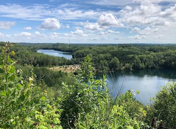
Cuyuna Country State Recreation Area occupies a distinctive corner of central Minnesota, where former iron-ore workings have become a landscape of deep mine lakes, wooded ridges and exposed red earth. The recreation area lies around the communities of Crosby, Ironton and Riverton, close to the larger regional centre of Brainerd. Its flooded open-pit mines, including Yawkey, Huntington and Pennington lakes, give the area a character unlike Minnesota’s more traditional lake districts: water fills steep-sided excavations, while forest and trail wind across the former mining ground.Read more about Cuyuna Country State Recreation Area
A Centre for Mountain Biking and Water Recreation
Iron Range Communities and Conservation
When is the best time to visit Cuyuna Country State Recreation Area?
Best: June–August · 24–26°C| Month | High (°C) | Rainfall (mm) |
|---|---|---|
| January | -6 | 20 |
| February | -4 | 20 |
| March | 5 | 31 |
| April | 12 | 50 |
| May | 18 | 76 |
| June (best) | 24 | 99 |
| July (best) | 26 | 92 |
| August (best) | 24 | 95 |
| September | 19 | 80 |
| October | 12 | 62 |
| November | 4 | 38 |
| December | -2 | 25 |
Getting to and around Cuyuna Country State Recreation Area
How to get there
Transportation
Best attractions in Cuyuna Country State Recreation Area
Cuyuna Country’s principal attractions are the former mine landscapes and the recreation they now support. The extensive Cuyuna Lakes Mountain Bike Trail System crosses wooded ridges, rolling spoil ground and overlooks above flooded pits, with routes designed for a range of riding abilities. Yawkey Mine Lake, Huntington Lake and Pennington Lake illustrate the scale and character of the open-pit workings, while other water bodies and forested sections offer opportunities for fishing, paddling, wildlife observation and quiet walks where permitted. The paved Cuyuna Lakes State Trail connects Crosby, Riverton and neighbouring communities on a gentler route suited to cycling and walking. In Crosby and Ironton, interpretive material and surviving traces of the mining landscape provide context for the area’s industrial past. The recreation area’s appeal lies in the contrast between engineered terrain, clear blue water, regenerating woodland and the active outdoor culture that has developed around them.
-
Park
Crosby Memorial Park
Discover the beauty and tranquility of Crosby Memorial Park, a perfect blend of nature and recreation in the heart of Minnesota.
-
 Camping cabin
True North Basecamp
Experience the beauty of Minnesota at True North Basecamp, where nature meets comfort in a serene camping environment.
-
Resort hotel
Cuyuna Cove
Explore the beauty of Cuyuna Cove – a serene resort hotel in Minnesota's breathtaking Cuyuna Lakes region, perfect for relaxation and adventure.
-
Brewery
Cuyuna Brewing Company
Experience the rich flavors of craft beer at Cuyuna Brewing Company in Crosby, Minnesota, where local brewing traditions come to life.


Best landmarks in Cuyuna Country State Recreation Area
The defining landmarks of Cuyuna Country are its flooded open-pit mines, especially the long, steep-sided lakes that reveal the scale of twentieth-century iron extraction. Yawkey, Huntington and Pennington lakes are prominent examples of industrial excavations transformed into water landscapes, while the red and earth-toned spoil ground remains a visible reminder of the ore-bearing range. The network of engineered mountain-bike trails has become a contemporary landmark in its own right, showing how former industrial terrain has been adapted for recreation. The Cuyuna Lakes State Trail provides a linear connection through the wider mining landscape, and Crosby, Ironton and Riverton retain the settlement pattern of an Iron Range community. Rather than a concentration of grand historic buildings, Cuyuna’s significance lies in the relationship between mine workings, lakes, woodland, infrastructure and the communities that grew around extraction.
-
Park
Cuyuna Country State Recreation Area Parking Lot
Discover the stunning landscapes and outdoor adventures at Cuyuna Country State Recreation Area, a must-visit destination for nature lovers in Minnesota.
Explore Cuyuna Country State Recreation Area on the map
Plan your trip on one map. See where the top attractions, landmarks, restaurants and hotels are, and book hotels and experiences in a few clicks.
Best hotels in Cuyuna Country State Recreation Area
Best restaurants in Cuyuna Country State Recreation Area
Dining is concentrated in Crosby, Ironton, Riverton and the wider Brainerd Lakes area rather than beside every trailhead or mine lake. Visitors can expect the practical range associated with small northern Minnesota communities: cafés, casual restaurants, bakeries, diners, bars serving food and places oriented towards cyclists and other outdoor visitors. Regional menus commonly draw on American comfort food, freshwater fish where available, burgers, sandwiches, soups and seasonal produce, while grocery shops and convenience stores are useful for packed lunches and trail supplies. The area’s mining and lake-country character is reflected more in its informal community hospitality than in a highly formalised food scene. Those staying outside the gateway towns should plan meals and provisions in advance, particularly when spending a full day on widely separated trails or water routes.
-
State park
Cuyuna Country State Recreation Area
Explore Minnesota's Cuyuna Country State Recreation Area: A breathtaking escape filled with lakes, trails & wildlife.

Best bars in Cuyuna Country State Recreation Area
Evenings in Cuyuna Country are generally quiet and community-oriented rather than centred on nightclubs. Crosby and Ironton have the area’s main concentration of pubs, bars and restaurants where visitors can find a relaxed drink, a meal and conversation after cycling or exploring the lakes. Some establishments may host seasonal gatherings or occasional music, but entertainment schedules and opening arrangements vary. Brainerd and Baxter, outside the recreation area, provide a broader choice of bars and evening venues for those seeking a more developed nightlife scene. Around Cuyuna itself, the appeal after dark is more likely to be a calm meal, a local event or the stillness of a rural lakeside setting; visitors should not expect a dense entertainment district or late-night transport network.
-
Family-friendly
North Country Cafe
Discover North Country Cafe in Crosby, MN, where hearty breakfasts, a welcoming atmosphere, and family-friendly dining await.
-
Restaurant
Iron Range Eatery
Discover the culinary delights of Iron Range Eatery in Crosby, MN - a perfect blend of American cuisine and unique cocktails.
-
Grill
Bridge Tavern
Experience the heart of Minnesota's dining scene at Bridge Tavern, where delicious grilled meals and friendly service await in Crosby.
-
American
Croft Kitchen and Bar
Experience the best of American cuisine at Croft Kitchen and Bar in Crosby, Minnesota, where hearty meals meet a warm, inviting atmosphere.


Best shops in Cuyuna Country State Recreation Area
Shopping in Cuyuna Country is practical, local and closely linked to outdoor recreation. Crosby and Ironton contain the main cluster of independent businesses, cafés, grocery provision and outdoor retailers, while Brainerd and Baxter offer the widest selection of general shops and services outside the recreation area. Cycling businesses are particularly important to the local visitor economy, providing equipment, clothing, repairs and route knowledge, although stock and services vary by season. Visitors may also find locally made art, gifts and food products through small businesses and community events rather than through a large permanent craft market. Because trailheads and mine lakes are dispersed, buy snacks, water, fuel and any specialist equipment before heading into the more remote sections. Retail facilities around the recreation area are limited compared with an urban destination.
-
State park
Cuyuna Country State Recreation Area
Discover the breathtaking beauty and outdoor adventures at Cuyuna Country State Recreation Area, a must-visit state park in Minnesota.
-
Bicycle rental service
Red Raven
Discover the Best Bicycle Rental and Repair Service in Crosby, MN – Perfect for Exploring the Scenic Cuyuna Lakes Trails!
-
State park
Cuyuna Lakes Mtn Bike Trails
Discover the stunning Cuyuna Lakes Mountain Bike Trails, where adventure meets breathtaking nature in Minnesota's premier biking destination.
-
Park
Cuyuna Mountain Bike Park & Campground
Discover the breathtaking Cuyuna Mountain Bike Park & Campground, where adventure meets tranquility in stunning Minnesota landscapes.


Get your free copy of our complete guide to Cuyuna Country State Recreation Area, delivered straight to you.
Everything on this page, from attractions and restaurants to essentials and local phrases, in one PDF you can read offline, print or share.
Already have an account? Sign in
Your Cuyuna Country State Recreation Area guide is ready.
We'll send it to · Not you? Sign out

Getting your guide ready…
We are putting together a fresh copy of the Cuyuna Country State Recreation Area guide. This can take up to a minute.
This can take a few moments. If your browser asks, choose Allow so the download can start. You'll find the guide in your Downloads folder.
Nothing happened? Download it again
Sorry, the guide is taking longer than usual. Please try again in a minute, or get it by email instead.
Cuyuna Country State Recreation Area essentials
Currency and Payment
Safety
Emergency Situations
Do's and Don'ts
Local Tips
From Eve
Local phrases worth knowing
You don't need to get them perfect. A few words go a long way, and locals appreciate the effort.
Basics
| English | Local | Say it |
|---|---|---|
| Hello | Tansay | [tan-say] |
| Goodbye | Adios | [ah-dee-ohs] |
| Yes | Oo | [oh] |
| No | Hindi | [hin-dee] |
| Please/You're welcome | Kuyay | [koo-yay] |
| Thank you | Salamat | [sah-lah-mat] |
| Excuse me/Sorry | Patawarin mo ako | [pa-ta-wa-rin mo ah-ko] |
| How are you? | Kamusta ka? | [ka-moo-sta ka] |
| Fine. And you? | Mabuti. Ikaw? | [ma-boo-tee. ee-kaw] |
| Do you speak English? | Nagsasalita ka ng Ingles? | [nag-sa-sa-lee-ta ka ng in-gles] |
| I don't understand | Hindi ko maintindihan | [hin-dee ko main-tin-di-han] |
Eating & Drinking
| English | Local | Say it |
|---|---|---|
| I'd like to see the menu, please | Gusto kong makita ang menu, pakiusap | [gus-to kong ma-ki-ta ang me-nu, pa-ki-oo-sap] |
| I don't eat meat | Hindi ako kumakain ng karne | [hin-dee ah-ko koo-ma-ka-een ng kar-ne] |
| Cheers! | Mabuhay! | [ma-boo-hay] |
| I would like to pay, please | Gusto kong magbayad, pakiusap | [gus-to kong mag-ba-ya-ad, pa-ki-oo-sap] |
Emergencies
| English | Local | Say it |
|---|---|---|
| Help! | Tulong! | [too-long] |
| Go away! | Lumayo ka! | [loo-ma-yo ka] |
| Call the Police! | Tawag sa pulisya! | [ta-wag sa pu-lee-sya] |
| Call a doctor! | Tawag sa doktor! | [ta-wag sa dok-tor] |
| I'm lost | Nawawala ako | [na-wa-wa-la ah-ko] |
| I'm ill | Maysakit ako | [may-sa-kit ah-ko] |
Shopping
| English | Local | Say it |
|---|---|---|
| I'd like to buy... | Gusto kong bumili ng... | [gus-to kong boo-mi-li ng] |
| I'm just looking | Nagmamasid lang ako | [nag-ma-ma-sid lang ah-ko] |
| How much is it? | Magkano ito? | [mag-ka-no ee-to] |
| That's too expensive | Masyadong mahal iyan | [ma-sya-dong ma-hal ee-yan] |
| Can you lower the price? | Pwede mo ibaba ang presyo? | [pwe-de mo e-ba-ba ang pres-yo] |
Time & Numbers
| English | Local | Say it |
|---|---|---|
| What time is it? | Anong oras na? | [a-non-g or-as na] |
| It's one o'clock | Alas uno na | [a-las oo-no na] |
| Half past (10) | Kalahating (sampu) | [ka-la-ha-ting (sam-poo)] |
| Morning | Umaga | [u-ma-ga] |
| Afternoon | Hapon | [ha-pon] |
| Evening | Gabi | [ga-bee] |
| Yesterday | Kahapon | [ka-ha-pon] |
| Today | Ngayon | [nga-yon] |
| Tomorrow | Bukas | [boo-kas] |
| 1 | Isa | [ee-sa] |
| 2 | Dalawa | [da-la-wa] |
| 3 | Tatlo | [tat-lo] |
| 4 | Apat | [a-pat] |
| 5 | Lima | [lee-ma] |
| 6 | Anim | [a-neem] |
| 7 | Pito | [pee-to] |
| 8 | Walo | [wa-lo] |
| 9 | Siyam | [see-yam] |
| 10 | Sampu | [sam-poo] |
Transport & Directions
| English | Local | Say it |
|---|---|---|
| Where's a/the...? | Saan ang...? | [sa-an ang] |
| What's the address? | Ano ang address? | [a-no ang ad-dress] |
| Can you show me (on the map)? | Pwede mo akong ipakita (sa mapa)? | [pwe-de mo a-kong ee-pa-kee-ta sa ma-pa] |
| When's the next (bus)? | Kailan ang susunod na (bus)? | [ka-ee-lan ang su-su-nod na bus] |
| A ticket (to ....) | Isang tiket (papuntang ...) | [ee-sang ti-ket pa-poon-tang] |
History of Cuyuna Country State Recreation Area
Glacial Terrain and Iron-Bearing Rock
Cuyuna Country’s physical setting reflects both ancient bedrock and the later action of glaciers. Iron-bearing formations in the Cuyuna Range supplied the mineral foundation for the region’s mining economy, while glacial deposits shaped the surrounding forests, wetlands and gently rolling ground. The dramatic lakes seen today are not natural basins in the usual sense: many occupy former open-pit mines and underground workings that later filled with water. This combination of geological resources and glacial landscape created the conditions for both industrial development and the distinctive post-mining recreation area.
Ojibwe Homelands and Early Settlement
The Cuyuna Range lies within the wider homeland and cultural landscape of the Ojibwe, whose relationship with northern Minnesota includes movement through forests and waters, seasonal harvesting and established traditions of place. During the nineteenth century, treaty-making and American expansion transformed land ownership and access, opening the way for increased non-Indigenous settlement. Later communities grew around transport routes, timber activity and the discovery of iron ore. The modern recreation area should therefore be understood within a much longer history than the mining period alone.
The Rise of the Cuyuna Iron Range
Commercial iron mining expanded in the Cuyuna Range during the early twentieth century, with ore production supporting new settlements, rail connections and a workforce drawn from many parts of the United States and overseas. Crosby, Ironton and nearby communities developed as service and residential centres for the mines. Both open-pit and underground methods were used, leaving excavations, waste rock, rail alignments and altered drainage patterns across the range. Mining shaped nearly every aspect of local life, from employment and housing to civic institutions and the region’s enduring identity.
Decline of Mining and Industrial Change
The Cuyuna Range faced increasing pressure from changing markets, competition from other sources of iron and the technical and economic difficulties of extracting ore from mature workings. Mining contracted sharply during the second half of the twentieth century, and the final operations closed in the 1980s. As employment disappeared, the communities confronted the familiar challenges of a rural industrial region adjusting to a post-mining economy. Pit lakes, spoil landscapes and abandoned industrial ground initially represented disruption and liability rather than recreation, even though they would later become central to a new regional identity.
From Mining District to Recreation Area
Public investment and local planning gradually recast parts of the former mining landscape as a destination for outdoor recreation. Cuyuna Country State Recreation Area was established by Minnesota in 2011, protecting a large mosaic of mine lakes, woodland and former industrial terrain. The development of a purpose-built mountain-bike trail system gave the area a new national profile, while the Cuyuna Lakes State Trail and water-based activities broadened its appeal. Conservation and tourism now operate alongside industrial heritage, with the altered landscape preserved as evidence of the range’s mining past rather than concealed.
Cuyuna Country State Recreation Area in Photos
Browse through our photo collection highlighting the charm and character of the destination.
Neighbouring destination travel guides
The closest destinations to Cuyuna Country State Recreation Area, if you have time for more than one.
-

-

-

-

-


Swipe for more destinations
Explore more

Explore more of Brainerd Lakes Area
Explore Minnesota’s Brainerd Lakes Area for boating, fishing, forest trails, resort towns, winter recreation and relaxed Northwoods culture.
Explore Brainerd Lakes Area
Explore more of Minnesota
Discover Minnesota: From the bustling Twin Cities and cultural landmarks to the serene lakes and expansive wilderness, experience the diverse beauty and welcoming spirit of the North Star State.
Explore Minnesota