Background

Bleasdale Circle

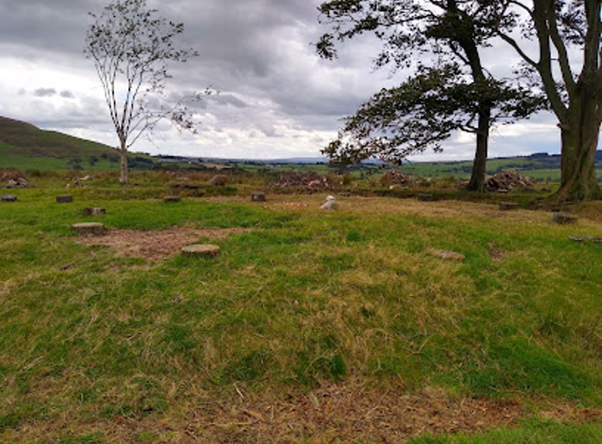
A Bronze Age timber circle and burial mound where ancient rituals echoed across the Bowland fells.

3.9

Bleasdale Circle is a Bronze Age timber circle and henge monument located on the remote fells near Garstang in Lancashire, England. Originally constructed around 1700 BC, the site comprises concentric rings of wooden posts surrounding a central burial mound. Today, concrete posts mark where the ancient timber once stood. Discovered in 1898 and partially excavated, this scheduled ancient monument offers a glimpse into Neolithic and Bronze Age ritual practices and burial customs in the Bowland uplands.

A brief summary to Bleasdale Circle

  • Preston, Bleasdale, GB
  • Visit website
  • Duration: 2.5 to 4 hours
  • Free
  • Environment icon Outdoor
  • Mobile reception: 2 out of 5

Local tips

  • The site requires a substantial uphill walk across open moorland; wear sturdy footwear and weather-appropriate clothing, as conditions on the fells can be exposed and changeable year-round.
  • Visit during clear weather to fully appreciate the panoramic views across the Bowland landscape and to safely navigate the moorland terrain.
  • Bring binoculars or a camera with zoom capability to observe the concrete marker posts clearly and to capture the wider landscape context of this remote monument.
  • Allow extra time for photography; the changing light across the fells creates dramatic shadows and atmospheric conditions, particularly during golden hour at sunrise or sunset.
  • Check local weather forecasts before visiting, as the exposed fells are prone to rapid weather changes, mist, and wind that can reduce visibility and accessibility.
widget icon

Getting There

  • Car and Walking

    Drive to Bleasdale village near Garstang (approximately 30–40 minutes from Preston city centre via the A6 north). Park near the village centre or at the small car park near Bleasdale Church. From there, follow the moorland footpath uphill across open fell terrain for approximately 45–60 minutes to reach the circle. The walk is steep and exposed; the final approach crosses untracked moorland. No admission fee. Terrain is rough grass and heather; waterproof boots essential.

  • Public Transport and Walking

    Take a bus from Preston to Garstang (approximately 45–60 minutes, several daily services, budget £3–5 return). From Garstang, walk or taxi to Bleasdale village (approximately 3–4 km, 40–50 minutes on foot). Follow the moorland path as described above. This option requires good fitness and planning around bus timetables.

  • Guided Walking Tour

    Join a guided moorland walk from a local outdoor activity provider or heritage organisation based in Garstang or the Bowland area. Tours typically depart from Garstang or nearby villages and include transport to the trailhead, expert interpretation, and navigation support. Duration approximately 4–5 hours including the walk. Costs typically range from £20–40 per person depending on group size and provider.

  • Cycling and Walking

    Cycle from Garstang to Bleasdale village via quiet country lanes (approximately 4–5 km, 20–30 minutes). Secure your bike near the village, then follow the moorland footpath uphill to the circle as described. This option combines easier initial access with the final moorland walk. Suitable for mountain bikes or hybrid bikes with good tread.

Bleasdale Circle location weather suitability

  • Weather icon Clear Skies
  • Weather icon Mild Temperatures

Unlock the Best of Bleasdale Circle

Buy tickets

    No tickets available

Book tours with entry

    No tours available

Book tours without entry

    No tours available

Discover more about Bleasdale Circle

An Ancient Ritual Landscape

Bleasdale Circle stands as one of Lancashire's most significant prehistoric monuments, a Bronze Age henge situated on the windswept fells near the village of Bleasdale. The site represents a sacred and ceremonial space dating to approximately 1700 BC, when early tribal communities inhabited these isolated uplands. The monument comprises two concentric circles of timber posts that once surrounded a central earthen mound, creating a ritual enclosure that served as a centre for religious worship and burial practices. The outer circle is believed to date from the earlier Neolithic period (4000–2000 BC), while the inner circle belongs to the Bronze Age (2000–700 BC), suggesting the site held significance across multiple millennia.

Excavation and Archaeological Discovery

The circle was rediscovered in 1898 by J. Kelsall and S. Jackson, who undertook the first systematic excavations between 1898 and 1900. Further investigations occurred in 1933–1935, revealing crucial details about the monument's construction and purpose. Archaeological work uncovered a timber palisade with a causeway leading to the central mound, which contained three cremation vessels—evidence of its use as a burial site for cremated remains. The excavations established that this was an enclosed Bronze Age urnfield, a place where the dead were ritually cremated and their ashes interred within the sacred circle. Today, the site is scheduled as a Historic England monument and remains an important record of prehistoric funerary practices.

The Monument Today

While little remains of the original wooden posts, eleven concrete markers now delineate the positions where the ancient timber circle once stood, allowing visitors to visualize the scale and layout of this Bronze Age construction. The surrounding ditch, part of the original henge design, is still visible as an earthwork feature. The monument sits at the foot of the Bowland Fells, in a small piece of woodland that frames the landscape much as it would have during the Bronze Age. The setting itself is remarkable—the circle is positioned equidistant from the headwaters of two rivers both named the River Brock, suggesting careful placement within the sacred geography of the ancient landscape. The views to the west stretch across wide horizons, and the fells rise dramatically beyond, creating an atmosphere of isolation and spiritual significance.

Landscape and Setting

The location within the Trough of Bowland places Bleasdale Circle in one of Lancashire's most dramatic upland regions. The fells surrounding the site are steep and exposed, creating a landscape that feels remote and timeless. The woodland enclosure provides shelter while maintaining sight lines across the moorland beyond. This elevated position would have made the site visible from considerable distances, potentially serving as a landmark for communities across the region. The natural amphitheatre formed by the surrounding hills may have enhanced the acoustic and visual impact of ceremonies conducted within the circle, amplifying the ritual significance of gatherings held here thousands of years ago.

Historical Significance

Bleasdale Circle represents a crucial window into Bronze Age society in northern England. The evidence of cremation burials, the careful construction of concentric circles, and the deliberate placement within the landscape all point to a sophisticated understanding of ritual, death, and the sacred. The site demonstrates that early communities in the Bowland region were not isolated but part of broader Bronze Age cultural networks. The presence of multiple burial vessels suggests this was a communal burial ground, possibly serving several generations or a wider tribal group. The monument's survival, despite millennia of weathering and agricultural use, testifies to its original construction quality and the enduring importance of the site within the local landscape.

Busiest months of the year

Busiest hours of the day

Popular Experiences near Bleasdale Circle

Popular Hotels near Bleasdale Circle

Select Currency