

Free Goldfields-Esperance Travel Guide & Mobile App
Explore Goldfields-Esperance with free travel guides. Discover regional history, expert tips, proposed trips, and audio guides on web or mobile app.


Explore Goldfields-Esperance for gold-rush heritage, remote desert journeys, wildflower country and the brilliant beaches of Esperance.
Read more about Goldfields-Esperance
When is the best time to visit Goldfields-Esperance?
Best: March–April, November · 24–27°C| Month | High (°C) | Rainfall (mm) |
|---|---|---|
| January | 29 | 20 |
| February | 30 | 20 |
| March (best) | 27 | 20 |
| April (best) | 24 | 30 |
| May | 19 | 30 |
| June | 16 | 40 |
| July | 15 | 40 |
| August | 16 | 30 |
| September | 19 | 30 |
| October | 22 | 30 |
| November (best) | 26 | 30 |
| December | 28 | 20 |
Getting to and around Goldfields-Esperance
How to get there
Transportation
Destinations in Goldfields-Esperance
Resorts, valleys and scenic spots worth a trip of their own.
-

-


Swipe for more destinations
Best attractions in Goldfields-Esperance
Goldfields-Esperance offers two very different but connected kinds of travel. Around Kalgoorlie-Boulder and Coolgardie, the attractions centre on gold-rush history, working mining landscapes, museums, historic streets and the engineering story of the Goldfields Water Supply Scheme. Leonora and Laverton provide access to remote inland country, while long highways lead towards the Great Victoria Desert and the Nullarbor's eastern approaches. These journeys reward preparation and a tolerance for distance rather than a tightly scheduled sightseeing itinerary. Around Esperance, the emphasis shifts to national parks, beaches, islands and coastal wildlife. Cape Le Grand National Park is known for Lucky Bay, Thistle Cove, granite formations and walking routes around Frenchman Peak, while Cape Arid National Park extends the experience into a more isolated coastal landscape. Fitzgerald River National Park near Hopetoun protects exceptionally diverse heathlands and rugged shorelines. Birdwatching, wildflower viewing, beach walking, fishing, scenic driving and boating are important activities, but facilities vary widely. The region's strongest attraction is the contrast between historic mining settlements, vast inland horizons and a southern coastline of unusual geological and botanical diversity.
-
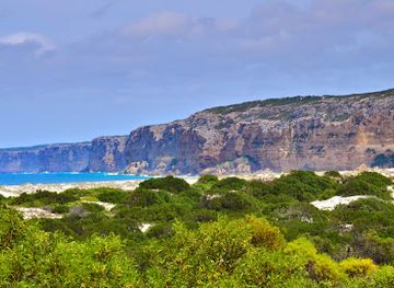
Bay
Twilight Cove
Explore the serene beauty of Twilight Cove, a hidden gem in Australia perfect for relaxation, nature walks, and stunning coastal photography.
Best landmarks in Goldfields-Esperance
Kalgoorlie-Boulder's most imposing modern landmark is the Super Pit, the vast open-cut mine that dominates the city's eastern skyline and conveys the continuing scale of gold extraction. Within the city, historic hotels, civic buildings and commercial terraces along Hannan Street preserve the visual character of the gold-rush era, while Coolgardie retains a quieter collection of nineteenth-century streets and heritage structures. The Goldfields Water Supply Scheme is less visually concentrated but remains a major regional engineering landmark, represented by surviving infrastructure and the route that brought water across the interior. On the coast, Frenchman Peak in Cape Le Grand National Park is a distinctive granite outcrop and a demanding walking landmark, while the pale sweep of Lucky Bay and the granite headlands around Thistle Cove define the region's southern image. The Recherche Archipelago forms a remarkable offshore landmark system of rocky islands and channels, best appreciated from coastal viewpoints or by water. Farther east, the granite and coastal heath of Cape Arid National Park underline the transition from Esperance's settled foreshore to more remote Southern Ocean country.
-
Tourist attraction
Pichi Richi Railway
Explore the Flinders Ranges aboard the historic Pichi Richi Railway, where scenic beauty and rich heritage come together for an unforgettable journey.

Explore Goldfields-Esperance on the map
Plan your trip on one map. See where the top cities, national parks and sights are, and book hotels and experiences in a few clicks.
Best hotels in Goldfields-Esperance
Best restaurants in Goldfields-Esperance
Dining in Goldfields-Esperance reflects its long distances and distinct inland and coastal economies. Kalgoorlie-Boulder has the broadest choice, including bakeries, cafés, clubs, pubs and restaurants serving familiar Australian meals alongside contemporary options. Historic goldfields hotels and community clubs remain important meeting places, while roadhouses and country bakeries are practical stops on longer drives. Esperance offers more coastal dining, with cafés, takeaway outlets and restaurants making use of seafood and local produce when available. Around the wider south coast, farm products, bread, preserves and seasonal produce appear at local markets and independent shops. The region is not defined by one signature dish, but visitors may encounter Western Australian seafood, lamb, beef, native ingredients and locally produced drinks. In rural areas, trading hours can be limited and kitchens may close earlier than visitors expect, so plan meals around fuel and accommodation rather than assuming a late-night choice will be available.
-
Tourist attraction
Pichi Richi Railway
Discover the historic Pichi Richi Railway in South Australia – a scenic journey through breathtaking landscapes and rich heritage.

Best bars in Goldfields-Esperance
Nightlife in Goldfields-Esperance is generally social and local rather than built around a large club scene. Kalgoorlie-Boulder has the region's widest evening choice, with traditional pubs, hotel bars, clubs, restaurants and occasional live music providing the main settings after dark. Its goldfields history is still visible in long-established hotel architecture and pub culture, though contemporary venues serve a mixed local and visiting population. Esperance offers relaxed pubs, cafés, restaurants and a small selection of bars, with evenings often shaped by the working town, seasonal visitors and the weather. In Leonora, Laverton, Coolgardie and smaller settlements, evening activity is centred on hotels, clubs and community venues rather than dedicated nightclubs. Rural inns and roadhouses may close early, and distances make drinking and driving particularly hazardous. Check current local arrangements rather than expecting a fixed entertainment district, especially outside Kalgoorlie-Boulder and Esperance.
-
Newspaper publisher
The Kimberley Echo
Explore Kununurra's vibrant culture through The Kimberley Echo, your essential guide to local news, events, and community stories.

Best nightclubs in Goldfields-Esperance
-
Hiking area
Kata Tjuta - Valley of the Winds
Explore the breathtaking landscapes and cultural significance of Kata Tjuta's Valley of the Winds, a premier hiking destination in Australia's Northern Territory.
-
Observation deck
Kata Tjuṯa Dunes Viewing Area
Experience the breathtaking vistas at Kata Tjuṯa Dunes Viewing Area, where nature's beauty meets cultural significance in the heart of Australia's Northern Territory.
-
Bar
Walpa Lobby Bar
Discover the Walpa Lobby Bar: A charming oasis in the heart of the Outback, serving delightful drinks and local flavors in a cozy atmosphere.
-
Toll booth
Uluru- Kata Tjuta National Park Entry Station
Discover the breathtaking landscapes and rich Indigenous culture at the Uluru-Kata Tjuta National Park Entry Station, a gateway to unforgettable adventures.


Best shops in Goldfields-Esperance
Shopping in Goldfields-Esperance is practical, local and closely tied to the region's mining, pastoral and coastal character. Kalgoorlie-Boulder has the largest concentration of supermarkets, services, independent retailers, galleries and souvenir outlets, with goldfields history and mining-themed products featuring prominently. Coolgardie offers heritage-oriented shopping and local crafts on a much smaller scale. Esperance provides the strongest selection of cafés, galleries, independent shops and coastal souvenirs, including locally made art, photography, jewellery and products inspired by beaches and native flora. Markets and farm-gate opportunities in the wider south coast may offer preserves, baked goods, honey, seasonal produce and handmade items, but schedules vary. Visitors should buy Aboriginal art only from reputable businesses that can explain the artist and provenance, and should never collect natural objects from beaches, national parks or culturally significant places. Remote settlements have limited retail choice, so stock up on food, water and basic supplies before leaving the main centres.
-
Tourist attraction
Pichi Richi Railway
Explore the stunning Flinders Ranges aboard the historic Pichi Richi Railway – a journey through time and breathtaking landscapes.
-
Homewares Store
Gibsons Noosa
Discover unique homewares and local craftsmanship at Gibsons Noosa, your go-to store for stylish decor and gifts in Queensland.
-
Fashion designer
Esperance & Co
Discover the art of bespoke fashion at Esperance & Co, where contemporary design meets timeless elegance in the heart of Frenchs Forest.
-
Gift shop
Victor Scot Gifts & Homewares - Ascot
Discover unique gifts and homewares at Victor Scot Gifts & Homewares in Ascot, where local craftsmanship meets delightful shopping.


Get your free copy of our complete guide to Goldfields-Esperance, delivered straight to you.
Everything on this page, from attractions and restaurants to essentials and local phrases, in one PDF you can read offline, print or share.
Already have an account? Sign in
Your Goldfields-Esperance guide is ready.
We'll send it to · Not you? Sign out

Getting your guide ready…
We are putting together a fresh copy of the Goldfields-Esperance guide. This can take up to a minute.
This can take a few moments. If your browser asks, choose Allow so the download can start. You'll find the guide in your Downloads folder.
Nothing happened? Download it again
Sorry, the guide is taking longer than usual. Please try again in a minute, or get it by email instead.
Goldfields-Esperance essentials
Currency and Payment
Safety
Emergency Situations
Do's and Don'ts
Local Tips
From Eve
Local phrases worth knowing
You don't need to get them perfect. A few words go a long way, and locals appreciate the effort.
Basics
| English | Local | Say it |
|---|---|---|
| Hello | G'day | [guh-day] |
| Goodbye | See ya | [see yah] |
| Yes | Yep | [yehp] |
| No | Nah | [nah] |
| Please/You're welcome | No worries | [noh war-reez] |
| Thank you | Cheers | [cheerz] |
| Excuse me/Sorry | Sorry mate | [saw-ree mate] |
| How are you? | How's it going? | [how's it goin?] |
| Fine. And you? | Good as gold, you? | [gud az gold, you?] |
| Do you speak English? | Can ya speak English? | [can yah speak Ing-lish?] |
| I don't understand | I don't get it | [I don't get it] |
Eating & Drinking
| English | Local | Say it |
|---|---|---|
| I'd like to see the menu, please | Can I see the menu, please? | [can I see the men-yoo, pleez?] |
| I don't eat meat | I'm a vegetarian | [I'm a vege-tair-ee-an] |
| Cheers! | Cheers! | [cheerz] |
| I would like to pay, please | Can I get the bill, please? | [can I get the bil, pleez?] |
Emergencies
| English | Local | Say it |
|---|---|---|
| Help! | Help! | [help] |
| Go away! | Buzz off! | [buhz off] |
| Call the Police! | Ring the cops! | [ring the cops] |
| Call a doctor! | Get a doctor! | [get a doc-tor] |
| I'm lost | I’m lost | [I'm lost] |
| I'm ill | I’m crook | [I'm crook] |
Shopping
| English | Local | Say it |
|---|---|---|
| I'd like to buy... | I wanna buy... | [I wanna buy...] |
| I'm just looking | Just browsing | [just brows-ing] |
| How much is it? | What’s the price? | [what's the price?] |
| That's too expensive | That’s a bit rich | [that’s a bit rich] |
| Can you lower the price? | Can you do a better price? | [can you do a better price?] |
Time & Numbers
| English | Local | Say it |
|---|---|---|
| What time is it? | What’s the time? | [what's the time?] |
| It's one o'clock | It's one o'clock | [it's one o'clock] |
| Half past (10) | Half past ten | [half past ten] |
| Morning | Morning | [morning] |
| Afternoon | Arvo | [ar-vo] |
| Evening | Evening | [evening] |
| Yesterday | Yesterday | [yes-ter-day] |
| Today | Today | [to-day] |
| Tomorrow | Tomorrow | [to-mor-row] |
| 1 | One | [one] |
| 2 | Two | [two] |
| 3 | Three | [three] |
| 4 | Four | [four] |
| 5 | Five | [five] |
| 6 | Six | [six] |
| 7 | Seven | [seven] |
| 8 | Eight | [eight] |
| 9 | Nine | [nine] |
| 10 | Ten | [ten] |
Transport & Directions
| English | Local | Say it |
|---|---|---|
| Where's a/the...? | Where's the...? | [where's the...?] |
| What's the address? | What’s the address? | [what's the ad-dress?] |
| Can you show me (on the map)? | Can you show me on the map? | [can you show me on the map?] |
| When's the next (bus)? | When's the next bus? | [when's the next bus?] |
| A ticket (to ....) | A ticket to ... | [a tik-it to ...] |
History of Goldfields-Esperance
Ancient Aboriginal cultural landscapes
Goldfields-Esperance has been home to Aboriginal peoples for many thousands of years. Communities including the Wongutha, Ngadju, Ngaanyatjarra, Mirning and other language groups maintain connections to country across the deserts, woodlands and southern coast, although the region contains many distinct cultural traditions rather than one single identity. Rock formations, water sources, trade routes and places of ceremony carry continuing significance. Visitors should recognise that some sites are restricted or culturally sensitive, and that the landscape's history extends well beyond the arrival of European explorers and miners.
Exploration and the inland frontier
European exploration of the south-eastern interior intensified during the nineteenth century as expeditions crossed difficult country in search of routes, water and pastoral opportunities. The journeys of explorers such as John Forrest helped map parts of the region, though Aboriginal people already knew its waterholes, seasonal resources and travel corridors. Later pastoral expansion brought sheep stations and new transport routes, altering access to country and creating conflict and disruption for Aboriginal communities. The region's large distances and harsh conditions continued to shape settlement patterns.
The eastern gold rush, 1890s
The discovery of gold near Coolgardie in 1892 and at Kalgoorlie soon afterwards transformed south-eastern Western Australia. Prospectors arrived from across Australia and overseas, and temporary camps developed into towns, mining settlements and supply centres. Coolgardie became an early focus of the rush, while Kalgoorlie grew rapidly after the rich Golden Mile deposits were identified. The rush brought railways, hotels, banks, newspapers and a highly diverse population, but it also involved severe hardship, environmental damage and the dispossession of Aboriginal people.
Water, railways and the growth of Kalgoorlie
The goldfields could not sustain a large population without reliable water and transport. C. Y. O'Connor's Goldfields Water Supply Scheme, completed in the early twentieth century, carried water from the Perth region to Kalgoorlie over hundreds of kilometres and became one of Australia's major engineering projects. Rail connections similarly linked the mining centres with the coast and agricultural districts. These developments helped turn Kalgoorlie-Boulder from a rush-era settlement into a permanent regional city, while Coolgardie declined in relative importance.
Mining, wartime change and modern industry
Gold mining remained central to the region through changing technologies, fluctuating prices and periods of closure. During the Second World War, mineral production and transport were important to Australia's wider industrial effort, while the broader region also saw changes in population and infrastructure. Modern open-cut and underground operations have expanded the scale of extraction around Kalgoorlie-Boulder, and nickel, iron ore and other resources have contributed to the economy in different periods. Mining continues to influence employment, landscapes and the services available in inland towns.
Esperance port and agricultural development
Esperance developed as a southern port serving the surrounding pastoral and agricultural districts. Its harbour became increasingly important for exporting grain and other products, connecting the region to national and international markets. The port and associated transport infrastructure helped broaden Esperance's economy beyond coastal fishing and small-scale settlement. At the same time, farming in the hinterland altered native vegetation and water systems, while the region's natural beaches, islands and national parks later became increasingly important to tourism.
Conservation and regional tourism
During the later twentieth century, growing recognition of the south coast's botanical richness and remote landscapes strengthened conservation efforts. National parks including Cape Le Grand, Cape Arid and Fitzgerald River protect habitats shaped by ancient geology, fire and seasonal rainfall. Tourism now links mining heritage in the Goldfields with coastal recreation and nature-based travel around Esperance, although access remains dependent on weather, road conditions and careful management. The region's contemporary identity therefore combines resource industries, Aboriginal cultural continuity, protected landscapes and long-distance travel.
Goldfields-Esperance in Photos
Browse through our photo collection highlighting the charm and character of the destination.
Neighbouring regions of Goldfields-Esperance
The closest regions to Goldfields-Esperance, if you have time for more than one.
-

-

-

-

-


Swipe for more regions
Explore more

Explore more of Australia
Discover the diverse landscapes, vibrant cities, and unique wildlife of Australia, a captivating destination offering endless adventures and unforgettable experiences.
Explore Australia