

Yungas Road Travel Guide - Free Web & App
Your ultimate guide to Yungas Road. Discover top landmarks, proposed trips, and local tips. Free on the web or via the Evendo companion app.


Yungas Road in Bolivia descends from the Andes into cloud forest, combining dramatic scenery, road history and guided mountain-bike adventures near Coroico.
From High Andes to Cloud Forest
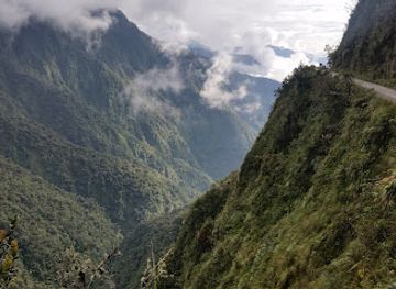
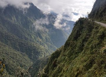
Yungas Road is the celebrated old mountain route descending from the high plateau near La Paz into Bolivia’s humid Yungas valleys. Often called the Death Road in international travel literature, it is best understood as a historic road corridor rather than a conventional sightseeing attraction. The most visited section is the North Yungas Road, running from the La Cumbre area through steep Andean terrain towards Yolosa, below the town of Coroico. The route passes from cold, exposed puna landscapes into increasingly warm, green cloud forest, with waterfalls, narrow ledges and deep ravines defining its character.Read more about Yungas Road
A Historic Route and Adventure Landscape
Gateway to the Yungas
When is the best time to visit Yungas Road?
Best: June–August · 28–29°C| Month | High (°C) | Rainfall (mm) |
|---|---|---|
| January | 28 | 174 |
| February | 28 | 159 |
| March | 29 | 132 |
| April | 29 | 86 |
| May | 29 | 47 |
| June (best) | 28 | 22 |
| July (best) | 28 | 26 |
| August (best) | 29 | 31 |
| September | 30 | 71 |
| October | 30 | 122 |
| November | 30 | 149 |
| December | 29 | 169 |
Getting to and around Yungas Road
How to get there
Transportation
Best attractions in Yungas Road
The principal attraction is the old North Yungas Road itself, where a narrow mountain line descends from the high plateau through cliffs, waterfalls and cloud forest towards Yolosa. The journey is less about individual monuments than about the changing landscape: the stark alpine environment around La Cumbre gives way to mossy slopes, dense vegetation and warmer valley scenery. Guided mountain-bike descents provide the established way to experience the route, while the road’s bends, retaining walls and exposed ravines reveal the engineering challenge of crossing the eastern Andes. At the lower end, the surroundings of Coroico offer valley viewpoints, rural walks and access to the wider Yungas, including areas of coffee and coca cultivation. La Paz is outside the road’s immediate landscape but functions as its principal departure point, and many excursions combine the route with transport and a short stay in Coroico rather than treating the road as a standalone overnight destination.
-
Historical landmark
طريق الموت
Explore the awe-inspiring Death Road in Bolivia, where adventure meets breathtaking landscapes and rich history.
-
Scenic spot
San Juan
Discover the breathtaking beauty of San Juan along N Yungas Rd, a scenic paradise in Bolivia offering tranquil landscapes and stunning views.
Best landmarks in Yungas Road
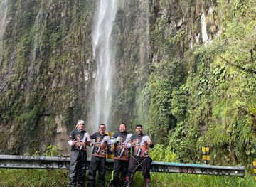
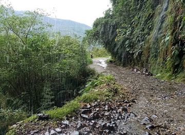
Yungas Road’s defining landmarks are natural and infrastructural rather than monumental. La Cumbre marks the high-altitude threshold where the route leaves the exposed Andean plateau and begins its descent towards the eastern valleys. Along the old road, sheer rock faces, narrow ledges, side cascades and deep ravines demonstrate the difficulty of building and maintaining a transport connection through the mountains. The road’s historic retaining walls and rough alignment are significant because they preserve the character of an earlier La Paz–Yungas route, while the newer highway illustrates the shift towards tunnels, bridges and safer engineered connections. Yolosa marks the lower end of many cycling itineraries, with Coroico beyond it serving as the principal settlement and visitor base. The transition from puna grassland to humid Yungas vegetation is itself the corridor’s most important geographical landmark.
-
Historical landmark
طريق الموت
Explore the breathtaking beauty and thrilling adventures of Bolivia's Road of Death, a historical landmark steeped in rich culture and stunning landscapes.
-
Scenic spot
San Juan
Discover the breathtaking landscapes of San Juan along Yungas Road, where stunning views and serene adventures await every traveler.
-
Historical landmark
Bajo Sacramento
Experience the rich history and stunning landscapes of Bajo Sacramento, a captivating landmark in Bolivia's picturesque Yungas region.
Explore Yungas Road on the map
Plan your trip on one map. See where the top attractions, landmarks, restaurants and hotels are, and book hotels and experiences in a few clicks.
Best hotels in Yungas Road
Get your free copy of our complete guide to Yungas Road, delivered straight to you.
Everything on this page, from attractions and restaurants to essentials and local phrases, in one PDF you can read offline, print or share.
Already have an account? Sign in
Your Yungas Road guide is ready.
We'll send it to · Not you? Sign out

Getting your guide ready…
We are putting together a fresh copy of the Yungas Road guide. This can take up to a minute.
This can take a few moments. If your browser asks, choose Allow so the download can start. You'll find the guide in your Downloads folder.
Nothing happened? Download it again
Sorry, the guide is taking longer than usual. Please try again in a minute, or get it by email instead.
Yungas Road essentials
Currency and Payment
Safety
Emergency Situations
Do's and Don'ts
Local Tips
From Eve
Local phrases worth knowing
You don't need to get them perfect. A few words go a long way, and locals appreciate the effort.
Basics
| English | Local | Say it |
|---|---|---|
| Hello | ¡Jiwawa! | [hee-wa-wa] |
| Goodbye | ¡Jupajpaki! | [hoo-pa-pa-kee] |
| Yes | ¡Ajja! | [ah-ha] |
| No | ¡Manqa! | [man-ka] |
| Please/You're welcome | ¡Imasunki! | [ee-ma-soon-kee] |
| Thank you | ¡Asañani! | [ah-sa-nya-nee] |
| Excuse me/Sorry | ¡Phutqayki! | [foo-tka-ykee] |
| How are you? | ¿Imaynataki? | [ee-ma-ee-na-ta-kee] |
| Fine. And you? | Ñoqaña. ¿Chaypi? | [nyo-ka-nya. chai-pee] |
| Do you speak English? | ¿Inka rimasqakita ingles simi? | [een-ka ree-mas-ka-kee-ta een-gles see-mee] |
| I don't understand | Mana yuyarni | [ma-na yoo-yar-nee] |
Eating & Drinking
| English | Local | Say it |
|---|---|---|
| I'd like to see the menu, please | ¡Mananawan rimasqayki, mana! | [ma-na-na-wan ree-mas-ka-ykee, ma-na] |
| I don't eat meat | Mana wañuchiy niy | [ma-na wa-nyoo-chee nee] |
| Cheers! | ¡Saki! | [sa-kee] |
| I would like to pay, please | ¡Mananawan qanpayki, mana! | [ma-na-na-wan kan-pa-ykee, ma-na] |
Emergencies
| English | Local | Say it |
|---|---|---|
| Help! | ¡Apuray! | [ah-poo-rai] |
| Go away! | ¡Jani! | [ha-nee] |
| Call the Police! | ¡Waskaray Polisia! | [wahs-ka-ry po-lee-see-ah] |
| Call a doctor! | ¡Waskaray dukturi! | [wahs-ka-ry dook-too-ree] |
| I'm lost | Ñuqa llimpuy | [nyoo-ka y-leem-pooi] |
| I'm ill | Ñuqapaqmi | [nyoo-ka-pak-mee] |
Shopping
| English | Local | Say it |
|---|---|---|
| I'd like to buy... | ¡Mananawan qallarqayki... | [ma-na-na-wan ka-lya-kay-kee] |
| I'm just looking | Ñuqallaniraqmi | [nyoo-kal-la-nee-rak-mee] |
| How much is it? | ¿Imaykita? | [ee-ma-ee-kee-ta] |
| That's too expensive | Kaymanchu sumaq | [kai-man-choo soo-mak] |
| Can you lower the price? | ¿Maypita? | [mai-pee-ta] |
Time & Numbers
| English | Local | Say it |
|---|---|---|
| What time is it? | ¿Imaynin? | [ee-ma-ee-neen] |
| It's one o'clock | ¡Juk llaqtan | [hoo-k y-lak-tan] |
| Half past (10) | ¡Iskaynata | [ees-kai-na-ta] |
| Morning | Pachamanta | [pa-cha-man-ta] |
| Afternoon | Inti chaski | [een-tee chas-kee] |
| Evening | Anata | [a-na-ta] |
| Yesterday | ¡Illapampa! | [ee-ya-pan-pa] |
| Today | ¡Kunan! | [koo-nan] |
| Tomorrow | ¡Mach'iq! | [mach-eeq] |
| 1 | Juk | [hoo-k] |
| 2 | Iskay | [ees-kai] |
| 3 | Kimsa | [keem-sa] |
| 4 | Tawa | [ta-wa] |
| 5 | Pichqa | [peech-ka] |
| 6 | Suqta | [sook-ta] |
| 7 | Qanchis | [kahn-chees] |
| 8 | Pusaq | [poo-sak] |
| 9 | Isqun | [ees-koon] |
| 10 | Chunka | [choon-ka] |
Transport & Directions
| English | Local | Say it |
|---|---|---|
| Where's a/the...? | ¿Manta... | [maan-ta] |
| What's the address? | ¿Imaynata... | [ee-ma-ee-na-ta] |
| Can you show me (on the map)? | ¿Maypita... | [mai-pee-ta] |
| When's the next (bus)? | ¿Kaynata... | [kai-na-ta] |
| A ticket (to ....) | ¡Tikiti (...) | [tee-kee-tee] |
History of Yungas Road
Pre-Colonial Andean Connections
The Yungas valleys have long been linked to the highlands through routes crossing the eastern slopes of the Andes. Indigenous communities used these connections to move between contrasting ecological zones, exchanging high-altitude crops and valley products. The broader Yungas became particularly associated with coca cultivation, whose leaves held important social, ceremonial and practical significance in Andean life. Although the present road is a modern construction, it follows a landscape shaped by much older movement between the altiplano and warmer eastern valleys.
Colonial Routes into the Yungas
During the colonial period, routes from the highlands into the Yungas acquired greater economic importance as Spanish authorities and settlers developed agriculture, mining supply networks and forced labour systems across the region. The valleys supplied coca and other warm-climate products to highland settlements and mining centres. Travel was difficult, and movement depended on steep paths, pack animals and local knowledge of the mountain environment. This history helps explain why a reliable road connection between La Paz and the Yungas became such an important infrastructure objective.
Construction of the Mountain Road
The road commonly known as Yungas Road was developed as a narrow route along the eastern Andean slopes during the twentieth century. Its alignment reflected the severe terrain, with rock faces on one side and deep ravines on the other. The route became notorious because of its difficult surface, limited width, rainfall, landslides and the consequences of vehicle errors. Its danger was intensified by its role as a working transport route rather than a purpose-built tourist attraction, carrying buses, lorries and local traffic through an environment with little margin for correction.
The New Highway and Adventure Tourism
A newer road with tunnels, bridges and a more engineered alignment gradually took over the main La Paz–Yungas connection, reducing the old route’s importance for through traffic. The historic road subsequently developed a new identity through guided mountain-bike excursions, especially on the descent from the highlands towards Yolosa. Adventure tourism transformed public perceptions of the route, but did not remove its physical hazards. Today, its significance lies in the combination of transport history, dramatic ecological change and a carefully managed form of recreational cycling.
Yungas Road in Photos
Browse through our photo collection highlighting the charm and character of the destination.
Neighbouring destination travel guides
The closest destinations to Yungas Road, if you have time for more than one.
-

-

-

-

-


Swipe for more destinations
Explore more

Explore more of Cordillera Real
Discover the Cordillera Real in Bolivia: A breathtaking mountain range offering spectacular trekking, climbing, and rich cultural experiences in the heart of South America.
Explore Cordillera Real
Explore more of Bolivia
Discover Bolivia: From the peaks of the Andes to the depths of the Amazon, a land of stunning landscapes and rich cultural heritage awaits.
Explore Bolivia